| Sunrise / Sunset Times for the Cascade Volcanoes
(page created February 2004, last updated May 2012) |
||||
|
During the spring and summer, the sun is the primary factor affecting the condition and quality of the snow surface.
Maximum enjoyment (and often personal safety, too) depends on proper timing relative to sunhit on the slopes of
interest for skiing and climbing. This page displays a table of the sunrise and sunset times throughout the year
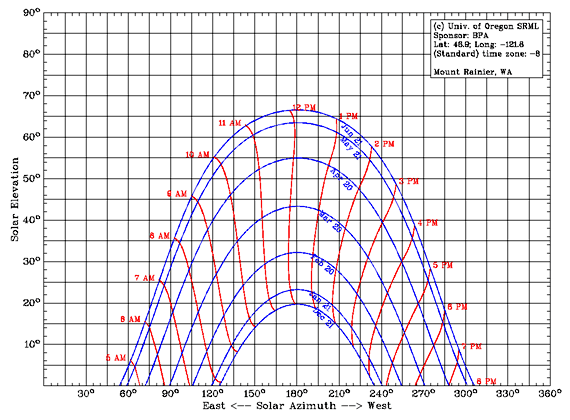
at several volcanoes spaced along the entire 750-mile (1200 km) length of the Cascade Range, along with a sun chart
for each which shows the elevation and azimuth of the sun throughout the winter and spring. The equinoxes and
solstices are highlighted in color in the table. The times for Civil Twilight (when the sun is less than 6°
below the horizon) are also included, since during this period there is usually sufficient light for climbing or
even skiing without artificial illumination. At these latitudes, twilight is longest at the summer solstice,
shortest at the equinoxes (when the sun rises and sets at its steepest angle), and moderately long again near the
winter solstice. Note that on the sun chart, all times shown are in local standard time (not solar time) and unlike the table, the chart does not include Daylight Saving Time. The second half of the year is nearly symmetrical, so the sun chart's curve for May 21 also applies for July 21 (and Apr 20 for Aug 21, Mar 20 for Sep 22, etc.) with only a tiny shift of a few minutes in the local time. |
||||
|
Currently, values and charts have been calculated only for the 10 volcanoes listed in the menu, for the year 2004
(although DST is now calculated using the new law which went into effect in 2007).
Solar times differ by only a few minutes for other years and at neighboring volcanoes, so this list
should be sufficient for all practical purposes. Note that all calculations are made assuming a site at sea
level at the given coordinates. At high elevations, the sun will rise several minutes earlier and set several
minutes later. Varying atmospheric conditions which affect the amount of refraction of the sun's rays can also
shift the rise and set times by several minutes. See the "Notes" at the bottom of the page for further info
about these calculations. Select a volcano from the menu at right to recalculate the first table and chart. The "Extended Version" has entries at roughly 10-day intervals, while the "Printable Format" produces a plain page without headers, footers, and text. The standard version in "Printable Format" will fit on a single printed page, but the "Extended Version" will not unless the font size is greatly reduced. Using "Landscape Format" will allow either version to fit on a single page printed in landscape orientation. Select a date from the menu at right to change the date shown in the lower table, which compares the sunrise / sunset times on the summer and winter solstices and the selected day throughout the length of the Cascade Range. |
||||
|
||||||||||||||||||||||||||||||||||||||||||||||||||||||||||||||||||||||||||||||||||||||||||||||||||||||||||||||||||||||||||||||||||||||||||||||||||||||||||||||||||||||||||||||||||||||||||||||||||||||||||||||||||||||||
|
||||||||||||||||||||||||||||||||||||||||||||||||||||||||||||||||||||||||||||||||||||||||||||||||||||||||||||||||||||||||||||||||||||||||||||||||||||||||||||||||||||||||||||||||||||||||||||||||||||||||||||||||||||||||
|
Comparison of Longest and Shortest Days of Year
with December 13 |
| Date . | Volcano | State / Province |
Location | Time Zone |
Twilight Begins |
Sunrise | Solar Noon |
Sunset | Twilight Ends |
Daylight Hours |
Twilight Hours |
Day + Twilight |
Maximum Solar Elev |
Sine (Max Solar Elev) |
|
| Jun 21 | Mount Meager | BC | 50.6° N, 123.6° W | PDT | 4:16 AM | 5:02 AM | 1:16 PM | 9:31 PM | 10:16 PM | 16:29 | 1:31 | 18:00 | 62.9° | 0.890 | |
| Jun 21 | Mount Garibaldi | BC | 49.8° N, 123.0° W | PDT | 4:19 AM | 5:04 AM | 1:14 PM | 9:24 PM | 10:08 PM | 16:20 | 1:29 | 17:49 | 63.7° | 0.896 | |
| Jun 21 | Mount Baker | WA | 48.8° N, 121.8° W | PDT | 4:21 AM | 5:04 AM | 1:09 PM | 9:14 PM | 9:57 PM | 16:10 | 1:26 | 17:36 | 64.7° | 0.904 | |
| Jun 21 | Mount Rainier | WA | 46.9° N, 121.8° W | PDT | 4:33 AM | 5:13 AM | 1:09 PM | 9:06 PM | 9:45 PM | 15:53 | 1:19 | 17:12 | 66.6° | 0.918 | |
| Jun 21 | Mount Adams | WA | 46.2° N, 121.5° W | PDT | 4:36 AM | 5:14 AM | 1:07 PM | 9:01 PM | 9:40 PM | 15:47 | 1:17 | 17:04 | 67.3° | 0.923 | |
| Jun 21 | Mount Hood | OR | 45.4° N, 121.7° W | PDT | 4:41 AM | 5:19 AM | 1:09 PM | 8:59 PM | 9:37 PM | 15:40 | 1:16 | 16:56 | 68.1° | 0.928 | |
| Jun 21 | Three Sisters | OR | 44.1° N, 121.8° W | PDT | 4:48 AM | 5:24 AM | 1:09 PM | 8:54 PM | 9:31 PM | 15:30 | 1:13 | 16:43 | 69.4° | 0.936 | |
| Jun 21 | Crater Lake | OR | 42.9° N, 122.1° W | PDT | 4:54 AM | 5:30 AM | 1:10 PM | 8:51 PM | 9:26 PM | 15:21 | 1:11 | 16:32 | 70.6° | 0.943 | |
| Jun 21 | Mount Shasta | CA | 41.4° N, 122.2° W | PDT | 5:02 AM | 5:36 AM | 1:11 PM | 8:46 PM | 9:20 PM | 15:10 | 1:08 | 16:18 | 72.1° | 0.952 | |
| Jun 21 | Lassen Peak | CA | 40.5° N, 121.5° W | PDT | 5:02 AM | 5:36 AM | 1:08 PM | 8:40 PM | 9:13 PM | 15:04 | 1:07 | 16:11 | 73.0° | 0.956 | |
| Dec 13 | Mount Meager | BC | 50.6° N, 123.6° W | PST | 7:29 AM | 8:08 AM | 12:09 PM | 4:10 PM | 4:49 PM | 8:02 | 1:18 | 9:20 | 16.2° | 0.279 | |
| Dec 13 | Mount Garibaldi | BC | 49.8° N, 123.0° W | PST | 7:24 AM | 8:02 AM | 12:06 PM | 4:11 PM | 4:49 PM | 8:09 | 1:16 | 9:25 | 17.0° | 0.293 | |
| Dec 13 | Mount Baker | WA | 48.8° N, 121.8° W | PST | 7:16 AM | 7:53 AM | 12:02 PM | 4:11 PM | 4:48 PM | 8:18 | 1:14 | 9:32 | 18.0° | 0.309 | |
| Dec 13 | Mount Rainier | WA | 46.9° N, 121.8° W | PST | 7:09 AM | 7:45 AM | 12:02 PM | 4:19 PM | 4:54 PM | 8:34 | 1:11 | 9:45 | 19.9° | 0.341 | |
| Dec 13 | Mount Adams | WA | 46.2° N, 121.5° W | PST | 7:06 AM | 7:41 AM | 12:00 PM | 4:20 PM | 4:55 PM | 8:39 | 1:10 | 9:49 | 20.6° | 0.352 | |
| Dec 13 | Mount Hood | OR | 45.4° N, 121.7° W | PST | 7:05 AM | 7:39 AM | 12:01 PM | 4:24 PM | 4:58 PM | 8:45 | 1:08 | 9:53 | 21.4° | 0.365 | |
| Dec 13 | Three Sisters | OR | 44.1° N, 121.8° W | PST | 7:01 AM | 7:34 AM | 12:01 PM | 4:29 PM | 5:02 PM | 8:55 | 1:06 | 10:01 | 22.7° | 0.386 | |
| Dec 13 | Crater Lake | OR | 42.9° N, 122.1° W | PST | 6:59 AM | 7:31 AM | 12:02 PM | 4:34 PM | 5:07 PM | 9:03 | 1:05 | 10:08 | 23.9° | 0.406 | |
| Dec 13 | Mount Shasta | CA | 41.4° N, 122.2° W | PST | 6:56 AM | 7:27 AM | 12:03 PM | 4:40 PM | 5:11 PM | 9:13 | 1:02 | 10:15 | 25.4° | 0.429 | |
| Dec 13 | Lassen Peak | CA | 40.5° N, 121.5° W | PST | 6:50 AM | 7:21 AM | 12:00 PM | 4:40 PM | 5:11 PM | 9:19 | 1:02 | 10:21 | 26.3° | 0.443 | |
| Dec 21 | Mount Meager | BC | 50.6° N, 123.6° W | PST | 7:34 AM | 8:14 AM | 12:13 PM | 4:12 PM | 4:51 PM | 7:58 | 1:19 | 9:17 | 15.9° | 0.274 | |
| Dec 21 | Mount Garibaldi | BC | 49.8° N, 123.0° W | PST | 7:29 AM | 8:07 AM | 12:10 PM | 4:14 PM | 4:52 PM | 8:07 | 1:16 | 9:23 | 16.7° | 0.287 | |
| Dec 21 | Mount Baker | WA | 48.8° N, 121.8° W | PST | 7:21 AM | 7:58 AM | 12:05 PM | 4:13 PM | 4:51 PM | 8:15 | 1:15 | 9:30 | 17.7° | 0.304 | |
| Dec 21 | Mount Rainier | WA | 46.9° N, 121.8° W | PST | 7:15 AM | 7:50 AM | 12:05 PM | 4:21 PM | 4:57 PM | 8:31 | 1:11 | 9:42 | 19.6° | 0.335 | |
| Dec 21 | Mount Adams | WA | 46.2° N, 121.5° W | PST | 7:11 AM | 7:46 AM | 12:04 PM | 4:23 PM | 4:58 PM | 8:37 | 1:10 | 9:47 | 20.3° | 0.347 | |
| Dec 21 | Mount Hood | OR | 45.4° N, 121.7° W | PST | 7:10 AM | 7:44 AM | 12:05 PM | 4:27 PM | 5:01 PM | 8:43 | 1:08 | 9:51 | 21.1° | 0.360 | |
| Dec 21 | Three Sisters | OR | 44.1° N, 121.8° W | PST | 7:06 AM | 7:39 AM | 12:05 PM | 4:32 PM | 5:05 PM | 8:53 | 1:06 | 9:59 | 22.4° | 0.381 | |
| Dec 21 | Crater Lake | OR | 42.9° N, 122.1° W | PST | 7:04 AM | 7:36 AM | 12:06 PM | 4:37 PM | 5:10 PM | 9:01 | 1:05 | 10:06 | 23.6° | 0.400 | |
| Dec 21 | Mount Shasta | CA | 41.4° N, 122.2° W | PST | 7:00 AM | 7:32 AM | 12:07 PM | 4:43 PM | 5:14 PM | 9:11 | 1:03 | 10:14 | 25.1° | 0.424 | |
| Dec 21 | Lassen Peak | CA | 40.5° N, 121.5° W | PST | 6:55 AM | 7:26 AM | 12:04 PM | 4:43 PM | 5:14 PM | 9:17 | 1:02 | 10:19 | 26.0° | 0.438 | |
| Notes: | • |
The sunrise, sunset, and twilight values in the tables were calculated using online programs from the
U.S. Naval Observatory, Astronomical Applications Department. The sun charts were produced using an online program from the University of Oregon Solar Radiation Monitoring Laboratory. An excellent source of information and formulas about solar angles and power is the online book Power From The Sun by William Stine and Michael Geyer. |
|||
| • | The time of "Solar Noon" varies throughout the year by about 31 minutes, due to both the tilt of the Earth's axis and the elliptical form of the Earth's orbit around the Sun. This difference between mean solar time and true solar time on any day is given by the "equation of time" (see Power From The Sun, section 3.1 and Wikipedia: Equation of time). Disregarding the one-hour offset due to Daylight Saving Time, the earliest solar noon relative to Standard Time occurs around November 3, while the latest occurs around February 12. | ||||
| • |
The column "Maximum Solar Elev" lists the maximum elevation angle above the horizon reached by the sun
(at the time listed for "Solar Noon"), which is given by: maximum solar elevation = 90° - abs( latitude - declination angle ). .. This varies seasonally by 47° between the summer and winter solstices, equal to twice the 23.5° tilt of the Earth's axis. |
||||
| • |
The column "Sine (Max Solar Elev)" lists the sine of that angle, which is proportional to the maximum solar radiation received by a flat surface at
solar noon on a clear day. The solar irradiance (power per unit area) incident on a flat surface at sea level at solar noon on a clear day (as would be
measured by an optical pyranometer, see
Power From The Sun, chapter 2) is approximately: maximum irradiance = 1000 * sin( maximum solar elevation ) W/m2. . This varies seasonally between the summer and winter solstices by a factor of roughly 2.2 at 40° N latitude, increasing to a factor of 3.2 at 50° N. In the summer, the geographic variation in irradiance is small, with the southern end of the range at 40° N receiving only about 7% more on the summer solstice than the northern end at 50° N. The geographic variation is much larger in winter, with about 60% more irradiance on the winter solstice at 40° N than at 50° N. |
||||
| • |
The declination angle is the angle between the Earth's equatorial
plane and a line connecting the centers of the Earth and Sun. For dates other than the solstices (when the declination angle is
equal to the tilt of the Earth's axis, +/- 23.5°), this uses an
approximate formula given in
Power From The Sun, equation 3.7: declination angle = 180/π * asin( 0.39795 * cos( π/180 * 0.98563 * (day of year - 173) ) ). .. This formula has a maximum error of about -1 degree for dates near the vernal equinox (March 20) due to the elliptical shape of Earth's orbit, and accuracy is much better during other seasons. |
| Version History | ||||||
| 1.0 | 14 Feb 2004 | First online release. Includes basic table (with sunrise/sunset and twilight times, along with calculations of daylight and day+twilight hours) and sun chart. | ||||
| 1.1 | 22 Feb 2004 | Added "Extended Version" and "Printable Format" options. | ||||
| 1.1.1 | 24 Jan 2005 | Minor update to PHP/MySQL connection. | ||||
| 1.1.2 | 25 Apr 2005 | Minor update to PHP/MySQL connection. | ||||
| 1.2 | 02 Oct 2009 | Fixed calculation of DST to reflect new 2007 DST rules. Added "Landscape Format" option. Added this Version History. | ||||
| 1.3 | 02 Oct 2009 | Added second table for "Comparison of Longest and Shortest Days of Year", including maximum solar elevation. | ||||
| 1.4 | 04 Oct 2009 | Expanded second table to include comparison with any selected day, which requires actually calculating the declination angle to get the maximum solar elevation. | ||||
| 1.4.1 | 05 Oct 2009 | Added maximum solar elevation to first table. Minor graphical updates. | ||||
| 1.5 | 12 Oct 2009 | Added calculations of solar noon and twilight hours to both tables. | ||||
| 1.5.1 | 14 Oct 2009 | Added direct links for comparisons with equinoxes. Minor code tweaks. | ||||
| 1.6 | 23 Oct 2010 | Added calculations of sine of maximum solar elevation to both tables. Expanded "Notes" above substantially. | ||||
| 1.6.1 | 14 May 2012 | Remove deprecated parameter in mktime() function due to changes in PHP 5.3.0. | ||||