Central Andes: Regional Map and Introduction
| Cordillera Blanca (Peru)
# ... The most challenging and popular peaks for climbers in the Andes are found in the Cordillera Blanca of Peru. This is a spectacularly glaciated range, with enormous ice-covered peaks second only to the Himalaya. The range is non-volcanic, and most peaks are difficult ice climbs even by the "easiest" route. There is, however, an established network of backcountry ski routes and guides based in the main town, Huaraz. The highest and most famous peak, Huascaran, is conversely one of the easiest climbs, and has been descended on skis. Most of the precipation in this range falls as snow, often quite heavy, during the southern summer, with more stable weather in winter (May-September). |
|
||
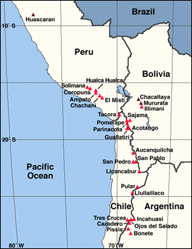 Select a mountain from the clickable map above |
|
Cordillera Occidental (Peru, Bolivia, and Chile)
# ... The central of three major volcanic regions in the Andes begins in southern Peru, and continues south for over 900 miles (1400 km) through western Bolivia into northern Chile and Argentina. The Cordillera Occidental runs along the western edge of the high plateau, the Altiplano, which averages nearly 13000 ft (4000 m) in altitude and divides the Andes into two parallel ranges in this region. Literally hundreds of volcanoes are found in this range, with over thirty major stratovolcanoes, including famous peaks such as El Misti, Sajama, and the twin cones of Parinacota and Pomerape. The entire region is quite arid, with the small precipitation falling as snow on the high peaks in summer. Despite the aridity, most of the high peaks over 19000 ft (5800 m) are capped with permanent snow and glaciers, with Coropuna bearing the largest ice cap at over 50 sq miles (130 sq km)! The symmetrical forms of most peaks makes them easy climbs, and good ski descents when snow conditions are right. Interestingly, many of these peaks were first climbed by the Incas, 500 years before other mountaineers reached such elevations, and Inca ruins, artifacts, and sacrificial victims have been found on several summits (see National Geographic, March 1992, for an interesting article). |
|
| Cordillera Real (Bolivia)
# ... On the eastern side of the Altiplano in Bolivia rise the heavily glaciated peaks of the Cordillera Real. There are numerous spectacular and difficult peaks in the range, but several of the high peaks are also gentler ascents ideally suited for skis, including Mururata and the highest peak, Illimani. In addition, the highest ski area in the world (ancient and meager though it is) is found on a minor peak, Chacaltaya. The Cordillera Real is quite popular with mounatineers. The climate is similar to the Cordillera Blanca, with snowfall in summer and stable weather during the winter dry season. |
|||
| Puna de Atacama Region (Chile and Argentina)
# ... The volcanic chain of the Cordillera Occidental becomes increasingly arid, desolate, and higher in altitude south of the Chile, Bolivia, and Argentina border junction. This region is the Puna (plateau) de Atacama, one of the highest and driest areas in the world. It lies to the east of the Atacama Desert in Chile, the world's driest, with no recorded rainfall (ever!) in some parts. Less than 100 miles (160 km) offshore lies the deepest portion of the Peru-Chile Trench [over 26000 ft (8000 m) deep], which is the subduction zone where the South American Plate is overriding the Nazca Plate, causing the uplift and volcanism of the entire Andes, including the Puna de Atacama. Over thirty 20000 ft (6000 m) peaks are found around the Puna, including six of the ten highest peaks in the Andes, yet most have little permanent snow or ice. The very highest summits do have small snowfields and glaciers, including Llullaillaco and Ojos del Salado, which are the highest active volcanoes in the world. The biggest obstacle to climbing is the isolation and difficult access, with very long, waterless hikes needed unless private 4WD vehicles are available. |
|||