| Northern OR: I-84 Portland, Columbia Gorge, Blue Mtns, Wallowa Mtns Hwy Corridor .. |
||||||||||||||||||||||||||||||||||||||||||||||||||||||||||||||||||||||||||||||||||||||||||||||||||||||||||||||||||||||||||||||||||||||||||||||||||||||||||||||||||||||||||||||||||||||||||||||||||||||||||||||||||||||||||||||||||||||||||||||||||||||||||||||||||||||||||||||||||||||||||||||||||||||||||||||||||||||||||||||||||||||||||||||||||||||||||||||||||||||||||||||||||||||||||||||||||||||||||||||||||||||||||||||||||||||||||||||||||||||||||||||||||||||||||||||||||||||||||||||||||||||||||||||||||||||||||||||||
 |
NWS Portland, Bonneville Dam Cam on I-84 @ MP 40, looking north *  Elevation: 100 ft |
NWS Portland, Bonneville Dam Cam on I-84 @ MP 40, looking east *  Elevation: 100 ft |
NWS Portland, Bonneville Dam Cam on I-84 @ MP 40, looking west *  Elevation: 100 ft |
 |
 |
HatchCam, looking west, Hood River on I-84 @ MP 63 *  Elevation: 100 ft |
Full Sail Brewing, Hood River on I-84 @ MP 63 *  Elevation: 100 ft |
KATU Hood River Camera, located on the north side of the Columbia River, often looking south towrds Mt Hood *  Elevation: 1000 ft |
Mt Hood / Parkdale, west of ORE 35 * Elevation: 2100 ft |
 |
 |
 |
Eastern Oregon Higher Ed Center, Hermiston, on US 395 north of I-84 @ MP 188 *  Elevation: 600 ft |
 |
Blue Mountain Community College, Pendleton, I-84 @ MP 207 *  Elevation: 1100 ft |
 |
 |
 |
 |
Tollgate on ORE 204 * Elevation: 5050 ft |
Eastern Oregon University, La Grande, south of I-84 @ MP 261 *  Elevation: 2850 ft |
Enterprise Airport Webcam, on ORE 82 *  Elevation: 3960 ft |
Enterprise Airport Webcam, on ORE 82 *  Elevation: 3960 ft |
Sheep Ridge Webcam, near Enterprise on ORE 82, looking north from Wallowa Mtns * Elevation: 7000 ft |
Joseph on ORE 82, looking south towards Wallowa Mtns *  Elevation: 3980 ft |
Joseph on ORE 82, looking west towards Wallowa Mtns *  Elevation: 3980 ft |
Wallowa Lake Webcam, south of Joseph *  Elevation: 4400 ft |
 |
 |
 |
 |
 |
Ukiah USFS Cam, on ORE 244 * Elevation: 3400 ft |
 |
 |
 |
 |
|||||||||||||||||||||||||||||||||||||||||||||||||||||||||||||||||||||||||||||||||||||||||||||||||||||||||||||||||||||||||||||||||||||||||||||||||||||||||||||||||||||||||||||||||||||||||||||||||||||||||||||||||||||||||||||||||||||||||||||||||||||||||||||||||||||||||||||||||||||||||||||||||||||||||||||||||||||||||||||||||||||||||||||||||||||||||||||||||||||||||||||||||||||||||||||||||||||||||||||||||||||||||||||||||||||||||||||||||||||||||||||||||||||||||||||||||||||||||||
| Northern OR: US 26 Mount Hood Hwy, US 97 Hwy Corridor .. |
||||||||||||||||||||||||||||||||||||||||||||||||||||||||||||||||||||||||||||||||||||||||||||||||||||||||||||||||||||||||||||||||||||||||||||||||||||||||||||||||||||||||||||||||||||||||||||||||||||||||||||||||||||||||||||||||||||||||||||||||||||||||||||||||||||||||||||||||||||||||||||||||||||||||||||||||||||||||||||||||||||||||||||||||||||||||||||||||||||||||||||||||||||||||||||||||||||||||||||||||||||||||||||||||||||||||||||||||||||||||||||||||||||||||||||||||||||||||||||||||||||||||||||||||||||||||||||||||
 |
 |
KATU Portland Bank Camera, atop US Bancorp Tower, often looking SE towrds Mt Hood *  Elevation: 600 ft |
OHSU Tram Cam, KGW-TV, off US 26 at I-5 in Portland *  Elevation: 500 ft |
 |
 |
 |
 |
 |
 |
Mt Hood, Charlie's Mountain View Restaurant in Government Camp on US 26 *  Elevation: 3900 ft |
 |
Mt Hood, Timberline Lodge KGW-TV Webcam, off US 26 *  Elevation: 5900 ft |
Mt Hood, Timberline Lodge USFS Cam, off US 26 *  Elevation: 5900 ft |
Mt Hood, Timberline Lodge Webcam, off US 26 *  Elevation: 5900 ft |
Mt Hood, Timberline Lodge Webcam, off US 26 *  Elevation: 5900 ft |
Mt Hood, Timberline Lodge Webcam, off US 26 *  Elevation: 5900 ft |
Mt Hood, Timberline Lodge Webcam, off US 26 *  Elevation: 5900 ft |
Mt Hood, Timberline Lodge Webcam, off US 26 *  Elevation: 5900 ft |
 |
 |
 |
 |
Mt Hood Meadows, off ORE 35, top of Cascade Express * Elevation: 7300 ft |
Mt Hood Meadows, off ORE 35, top of Blue Chair * Elevation: 6600 ft |
Mt Hood Meadows, off ORE 35, top of Vista Express * Elevation: 6600 ft |
Mt Hood Meadows, off ORE 35, top of Heather Canyon lift * Elevation: 6000 ft |
Mt Hood Meadows, off ORE 35, bottom of of Vista Express * Elevation: 5250 ft |
Mt Hood Meadows, off ORE 35, base area * Elevation: 5250 ft |
 |
 |
Rock Creek Reservoir, Wamic, west of US 197, looking NW towards Mt Hood *  Elevation: 2280 ft |
Maupin on US 197 @ MP 45, looking north from Maupin High School * Elevation: 1100 ft |
Grass Valley on US 97 @ MP 25, looking west towards Mt Hood * Elevation: 2300 ft |
 |
View of Mt Jefferson from Jefferson County Middle School in Madras, on US 97 @ MP 95 *  Elevation: 2300 ft |
View of Mt Jefferson from ESE, Six Springs Ranch Weather Cam, east of US 26 in Grizzly * Elevation: 3900 ft |
Mitchell on US 26 near junction of ORE 207, looking north from Mitchell School * Elevation: 2800 ft |
 |
||||||||||||||||||||||||||||||||||||||||||||||||||||||||||||||||||||||||||||||||||||||||||||||||||||||||||||||||||||||||||||||||||||||||||||||||||||||||||||||||||||||||||||||||||||||||||||||||||||||||||||||||||||||||||||||||||||||||||||||||||||||||||||||||||||||||||||||||||||||||||||||||||||||||||||||||||||||||||||||||||||||||||||||||||||||||||||||||||||||||||||||||||||||||||||||||||||||||||||||||||||||||||||||||||||||||||||||||||||||||||||||||||||||||||||||||||||||||||
| North-Central OR: ORE 18, I-5, US 20, ORE 22, ORE 126 Santiam Pass Hwy Corridor .. |
||||||||||||||||||||||||||||||||||||||||||||||||||||||||||||||||||||||||||||||||||||||||||||||||||||||||||||||||||||||||||||||||||||||||||||||||||||||||||||||||||||||||||||||||||||||||||||||||||||||||||||||||||||||||||||||||||||||||||||||||||||||||||||||||||||||||||||||||||||||||||||||||||||||||||||||||||||||||||||||||||||||||||||||||||||||||||||||||||||||||||||||||||||||||||||||||||||||||||||||||||||||||||||||||||||||||||||||||||||||||||||||||||||||||||||||||||||||||||||||||||||||||||||||||||||||||||||||||
 |
 |
 |
 |
 |
 |
Marys Peak viewed from OSU in Corvallis on ORE 34, west of I-5 @ MP 228 *  Elevation: 300 ft |
 |
|
Mill City on ORE 22 *  Elevation: 800 ft |
 |
 |
 |
Hoodoo Ski Area off US 20, looking north toward US20 @ MP 79 below Hogg Rock *  Elevation: 5700 ft, looking down to 4400 ft |
 |
Hoodoo Ski Area off US 20, base area, looking SW *  Elevation: 4700 ft |
Hoodoo Ski Area off US 20, base area, looking WNW *  Elevation: 4700 ft |
Hoodoo Ski Area off US 20, base area, looking east at parking lot *  Elevation: 4700 ft |
Hoodoo Ski Area off US 20, base area, looking SE at Hayrick Butte *  Elevation: 4700 ft |
Hoodoo Ski Area off US 20, summit of Hoodoo Butte *  Elevation: 5700 ft |
Hoodoo Ski Area off US 20, summit of Hoodoo Butte *  Elevation: 5700 ft |
Hoodoo Ski Area off US 20, summit of Hoodoo Butte, looking north toward US 20, Hogg Rock, Three Fingered Jack, and Mt Jefferson  Elevation: 5700 ft |
Hoodoo Ski Area off US 20, top of Ed Thurston Chair *  Elevation: 5400 ft |
Hoodoo Ski Area off US 20, zoomed view looking NNE at Three Fingered Jack and Mt Jefferson *  Elevation: 5400 ft |
Hoodoo Ski Area off US 20, zoomed view looking SSE at Mt Washington, North Sister, and Middle Sister *  Elevation: 5400 ft |
Hoodoo Ski Area off US 20, view looking NNW towards Green Chair and Maxwell Butte *  Elevation: 5400 ft |
Hoodoo Ski Area off US 20, top of Manzanita Chair *  Elevation: 5000 ft |
Hoodoo Ski Area off US 20, top of Manzanita Chair, looking east toward Black Butte *  Elevation: 5000 ft |
Hoodoo Ski Area off US 20, top of Easy Rider Chair *  Elevation: 4800 ft |
Hoodoo Ski Area off US 20, top of Easy Rider Chair, looking south at Hayrick Butte *  Elevation: 4800 ft |
Hoodoo Ski Area off US 20, top of Easy Rider Chair, looking SW at Hoodoo Butte *  Elevation: 4800 ft |
Hoodoo Ski Area off US 20, Autobahn (Tubing Hill)  Elevation: 4850 ft |
Hoodoo Ski Area off US 20, top of Easy Rider Chair, looking south at Hayrick Butte and SW at Hoodoo Butte  Elevation: 4800 ft |
Black Butte Ranch off US 20, looking WSW at Mt Washington *  Elevation: 3300 ft |
 |
||||||||||||||||||||||||||||||||||||||||||||||||||||||||||||||||||||||||||||||||||||||||||||||||||||||||||||||||||||||||||||||||||||||||||||||||||||||||||||||||||||||||||||||||||||||||||||||||||||||||||||||||||||||||||||||||||||||||||||||||||||||||||||||||||||||||||||||||||||||||||||||||||||||||||||||||||||||||||||||||||||||||||||||||||||||||||||||||||||||||||||||||||||||||||||||||||||||||||||||||||||||||||||||||||||||||||||||||||||||||||||||||||||||||||||||||||||||||||||||
| Central OR: ORE 126, FR 46 Cascade Lakes Hwy, US 97, US 20 Hwy Corridor .. |
||||||||||||||||||||||||||||||||||||||||||||||||||||||||||||||||||||||||||||||||||||||||||||||||||||||||||||||||||||||||||||||||||||||||||||||||||||||||||||||||||||||||||||||||||||||||||||||||||||||||||||||||||||||||||||||||||||||||||||||||||||||||||||||||||||||||||||||||||||||||||||||||||||||||||||||||||||||||||||||||||||||||||||||||||||||||||||||||||||||||||||||||||||||||||||||||||||||||||||||||||||||||||||||||||||||||||||||||||||||||||||||||||||||||||||||||||||||||||||||||||||||||||||||||||||||||||||||||
KEZI-TV Eugene SkyCam, off I-5 @ MP 192 in Eugene *  Elevation: 600 ft |
University of Oregon Weathercam, off I-5 @ MP 192 in Eugene *  Elevation: 500 ft |
 |
 |
 |
KVAL-TV Towercam, off I-5 @ MP 188 in SW Eugene *  Elevation: 1400 ft |
|
 |
 |
 |
Smith Rock, east of US 97 @ MP 115 *  Elevation: 2700 ft |
 |
 |
 |
 |
 |
BendWeather.com, east of Bend, looking west towards the Three Sisters *  Elevation: 3500 ft |
BendWeather.com, east of Bend, looking SW towards Mt Bachelor *  Elevation: 3500 ft |
BendWeather.com, east of Bend, looking east *  Elevation: 3500 ft |
Bend Municipal Airport, north of US 20 east of Bend * Elevation: 3500 ft |
Mt Bachelor Ski Area Base, off FR 46 * Elevation: 6350 ft |
Mt Bachelor Ski Area Base, Nordic Center Cam, off FR 46 * Elevation: 6350 ft |
Mt Bachelor Ski Area Base, Cone Cam, off FR 46 * Elevation: 6350 ft |
Mt Bachelor Ski Area, Sunrise Base, on FR 46 * Elevation: 6400 ft |
Mt Bachelor Ski Area, bottom of Summit Express * Elevation: 7300 ft |
Mt Bachelor Ski Area, Pine Marten Lodge, looking north at Three Sisters * Elevation: 7700 ft |
Mt Bachelor Ski Area, Pine Marten Lodge, looking at Outback Express * Elevation: 7700 ft |
 |
KGW-TV Sunriver Lodge Webcam, west of US 97, loooking NW towards Mt Bachelor *  Elevation: 4200 ft |
Sunriver Owners Association Office Web Cam, in Sunriver west of US 97 * Elevation: 4200 ft |
Sunray Office Web Cam, in Sunriver west of US 97 * Elevation: 4200 ft |
Sunriver Construction Camera, in Sunriver west of US 97 * Elevation: 4200 ft |
|
Brasada Ranch, near Powell Buttes, north of US 20, looking west at Three Sisters and Cascade Range *  Elevation: 3200 ft |
Pine Mountain Observatory, south of US 20, looking SE *  Elevation: 6300 ft |
Pine Mountain Observatory, south of US 20, looking SW * Elevation: 6300 ft |
 |
 |
|||||||||||||||||||||||||||||||||||||||||||||||||||||||||||||||||||||||||||||||||||||||||||||||||||||||||||||||||||||||||||||||||||||||||||||||||||||||||||||||||||||||||||||||||||||||||||||||||||||||||||||||||||||||||||||||||||||||||||||||||||||||||||||||||||||||||||||||||||||||||||||||||||||||||||||||||||||||||||||||||||||||||||||||||||||||||||||||||||||||||||||||||||||||||||||||||||||||||||||||||||||||||||||||||||||||||||||||||||||||||||||||||||||||||||||||||||||||||||
| South-Central OR: I-5, ORE 58, ORE 138, US 97 Willamette Pass & Crater Lake Hwy Corridor .. |
||||||||||||||||||||||||||||||||||||||||||||||||||||||||||||||||||||||||||||||||||||||||||||||||||||||||||||||||||||||||||||||||||||||||||||||||||||||||||||||||||||||||||||||||||||||||||||||||||||||||||||||||||||||||||||||||||||||||||||||||||||||||||||||||||||||||||||||||||||||||||||||||||||||||||||||||||||||||||||||||||||||||||||||||||||||||||||||||||||||||||||||||||||||||||||||||||||||||||||||||||||||||||||||||||||||||||||||||||||||||||||||||||||||||||||||||||||||||||||||||||||||||||||||||||||||||||||||||
 |
 |
 |
|
 |
 |
_pid503.jpg) |
KPIC-TV Weathercam, east of I-5 @ MP 125 *  Elevation: 1600 ft |
 |
 |
 |
 |
 |
 |
 |
|
 |
Willamette Pass Resort Web Cam, on ORE 58 *  Elevation: 5100 ft |
Willamette Pass SkyCam, on ORE 58 *  Elevation: 6600 ft |
 |
 |
 |
Crater Lake, Rim Village off ORE 62 *  Elevation: 7100 ft |
Crater Lake, Rim Village off ORE 62, view looking north at Wizard Island *  Elevation: 7100 ft |
Crater Lake from Sinnott Memorial, Rim Village off ORE 62, looking north at Wizard Island * 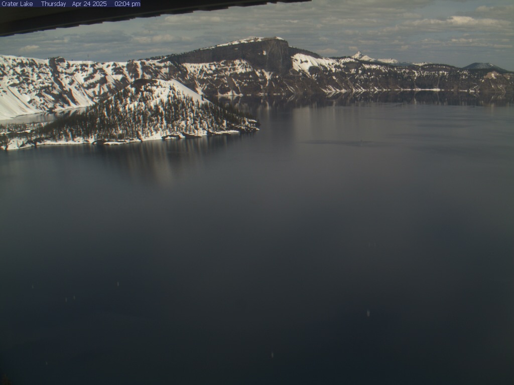 Elevation: 7100 ft |
Crater Lake, Steel Visitor Center, at Park Headquarters off ORE 62 *  Elevation: 6450 ft |
Crater Lake, Annie Springs entrance station at ORE 62 * 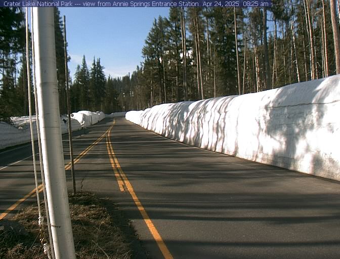 Elevation: 6000 ft |
 |
 |
_pid1726.jpg) |
 |
|
 |
 |
Frenchglen on ORE 205 *  Elevation: 4200 ft |
||||||||||||||||||||||||||||||||||||||||||||||||||||||||||||||||||||||||||||||||||||||||||||||||||||||||||||||||||||||||||||||||||||||||||||||||||||||||||||||||||||||||||||||||||||||||||||||||||||||||||||||||||||||||||||||||||||||||||||||||||||||||||||||||||||||||||||||||||||||||||||||||||||||||||||||||||||||||||||||||||||||||||||||||||||||||||||||||||||||||||||||||||||||||||||||||||||||||||||||||||||||||||||||||||||||||||||||||||||||||||||||||||||||||||||||||||||||||||||||
| Southern OR: I-5 / US 199 Siskiyous, ORE 140, US 95 Hwy Corridor .. |
||||||||||||||||||||||||||||||||||||||||||||||||||||||||||||||||||||||||||||||||||||||||||||||||||||||||||||||||||||||||||||||||||||||||||||||||||||||||||||||||||||||||||||||||||||||||||||||||||||||||||||||||||||||||||||||||||||||||||||||||||||||||||||||||||||||||||||||||||||||||||||||||||||||||||||||||||||||||||||||||||||||||||||||||||||||||||||||||||||||||||||||||||||||||||||||||||||||||||||||||||||||||||||||||||||||||||||||||||||||||||||||||||||||||||||||||||||||||||||||||||||||||||||||||||||||||||||||||
 |
 |
 |
Grants Pass Weather Cam, off US 199, west of I-5 @ MP 55, looking NE *  Elevation: 900 ft |
Grants Pass Weather Cam, on ORE 238, west of I-5 @ MP 55, looking north *  Elevation: 1000 ft |
Medford Oregon Weathercam, east of I-5 @ MP 33, distant view of Mount McLoughlin from 30 miles WSW *  Elevation: 1300 ft |
 |
 |
 |
 |
 |
 |
Ryan Weather Webcam, looking south from Medford, west of I-5 @ MP 27 *  Elevation: 1500 ft |
 |
 |
 |
 |
 |
Mt Ashland Ski Area, west of I-5 @ MP 6 * (Motion JPEG, 0.1 fps) Elevation: 6350 ft |
Green Springs Summit on ORE 66, east of Ashland *  Elevation: 4500 ft |
 |
 |
 |
Klamath Falls Webcam, on Main Street *  Elevation: 4100 ft |
 |
 |
 |
 |
 |
|
 |
 |
|||||||||||||||||||||||||||||||||||||||||||||||||||||||||||||||||||||||||||||||||||||||||||||||||||||||||||||||||||||||||||||||||||||||||||||||||||||||||||||||||||||||||||||||||||||||||||||||||||||||||||||||||||||||||||||||||||||||||||||||||||||||||||||||||||||||||||||||||||||||||||||||||||||||||||||||||||||||||||||||||||||||||||||||||||||||||||||||||||||||||||||||||||||||||||||||||||||||||||||||||||||||||||||||||||||||||||||||||||||||||||||||||||||||||||||||||||||||||||||||||
|
||||||||||||||||||||||||||||||||||||||||||||||||||||||||||||||||||||||||||||||||||||||||||||||||||||||||||||||||||||||||||||||||||||||||||||||||||||||||||||||||||||||||||||||||||||||||||||||||||||||||||||||||||||||||||||||||||||||||||||||||||||||||||||||||||||||||||||||||||||||||||||||||||||||||||||||||||||||||||||||||||||||||||||||||||||||||||||||||||||||||||||||||||||||||||||||||||||||||||||||||||||||||||||||||||||||||||||||||||||||||||||||||||||||||||||||||||||||||||||||||||||||||||||||||||||||||||||||||
