South Sister: Skiing the South Ridge (June 99)
        Amar Andalkar's Ski Mountaineering and Climbing Site
Home | Ski Mountaineering | Photos & Trip Reports | Equipment & Info | Cascade Volcanoes | Ring of Fire | Site Map
Trip Introduction | Route Map | Previous Page | Next Page

Mt Bachelor from the Highway
First View of the Three Sisters
Three Sisters and BrokenTop
Skiing Up past Broken Top
Looking Back at Mt Bachelor
Across the Plateau to South Sister
Map of South Sister Ski Route
Distant View of Diamond Peak
Skiing Up the Clark Glacier
Skiing Up the South Ridge
Skinning Up at Maxiumum Angle
Alex on the Crater Rim
Crater Rim and Mt Bachelor
View of North and Middle Sisters
Summit Rocks of South Sister
Skiing the Summit Pinnacle
Skiing into Summit Crater
Skiing down the South Ridge
Skiing the Clark Glacier Cornice
Skiing the Clark Glacier Cornice 2
Skiing Back across the Plateau
Evening Light on South Sister
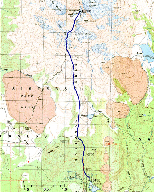
This map shows our ski route in blue (ascent and descent followed nearly the same path). Our route angles left from the hiking route (dashed black line) near 6900 ft, gains the toe of the Clark Glacier at 8200 ft, and then angles back right to head for the summit just west of the hiking route.
(Map created with TOPO! ©1999 Wildflower Productions, www.topo.com)
Trip Introduction | Route Map | Previous Page | Next Page
Home | Ski Mountaineering | Photos & Trip Reports | Equipment & Info | Cascade Volcanoes | Ring of Fire | Site Map
Amar Andalkar <andalkar@u.washington.edu>