| Cascade Snowfall and Snowdepth Summaries: 1970-2006 | ||
|
(last updated February 2006) See the main Cascade Snowfall and Snowdepth page for historical snowpack info. Detailed Snow Season Reports: 2005-2006, 2004-2005, 2003-2004, 2002-2003; see also Normals & Info and Cascades El Niño / La Niña NEW: Historical NWAC Snowdepth Data & Plots and Paradise & Crater Lake Snowfall/Snowdepth Plots |
||
|
This page was created in late 2004, out a desire to gain a historical perspective on large-scale
(both in distance and time) climatological snowfall patterns along the entire 800-mile length of the Cascade
Range. Skimountaineer.com has tracked snowdepth data recorded at numerous sites throughout the Cascade Range
since the 2002-2003 season, so it seemed quite natural to retroactively extend this back in time. I have been
collecting various snowfall and snowdepth data for the Cascades since about 1997, and much additional historical
data is available online, including US and Canadian weather data plus snow surveys from water resources / river
forecast centers in CA, OR, WA, and BC. This page contains a graphical summary of the snowfall and snowdepth in the
Cascade Range since the 1970-71 season. More detailed information (brief commentaries and ratings) is given for
each season since 1994-95, which was my first year living in the Pacific Northwest. I've included some data and
discussion of El Niño / La Niña correlations, since this is one of the dominant factors affecting
the quantity and large-scale distribution of snowfall along the Cascade Range (see the
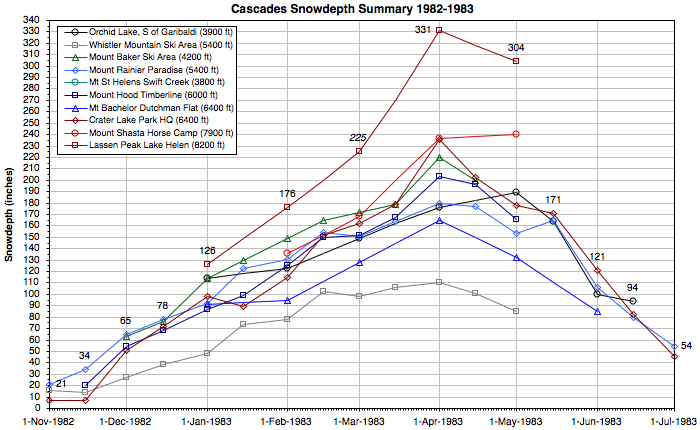
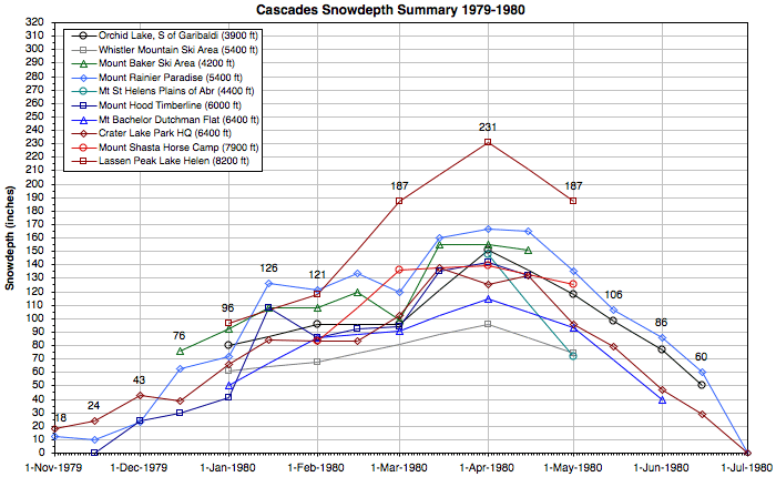
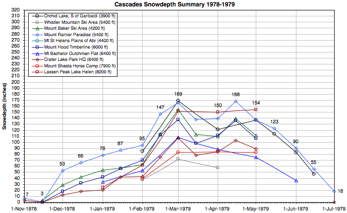
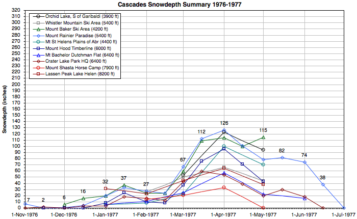
Cascades El Niño / La Niña page for more detailed info). The graphs below summarize snowdepths at 10 important sites throughout the entire Cascade Range in BC, WA, OR, and CA since the 1970-71 season, followed by a discussion of seasonal snowdepth leaders and brief summaries and ratings for each season since 1994-95. These graphs provide a quick visual survey of the buildup and melting of the snowpack from November 1 to July 1 throughout the range. Each season has its own distinctive shape caused by the temporal and spatial snowfall patterns during that year. The high-snowdepth sites included in these graphs are all located about 1000 ft below timberline and are representative of conditions in the subalpine regions on favored slopes (not rain-shadowed areas, except perhaps Whistler). In general, sites with hourly or daily data (versus monthly snow courses) have been selected for the summary graphs, and only 10 sites are shown in order to keep the graphs from becoming too busy. Place your mouse over the links below to compare the plots for each season and also the normal values for the period of record (this only works if you have a JavaScript-enabled browser). |
||

|
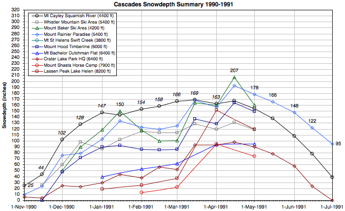
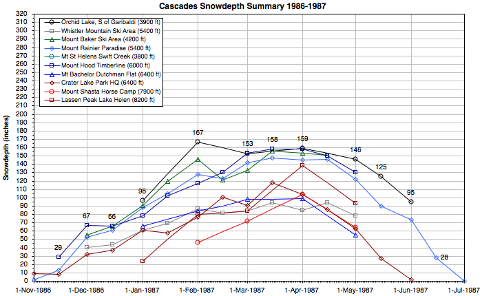
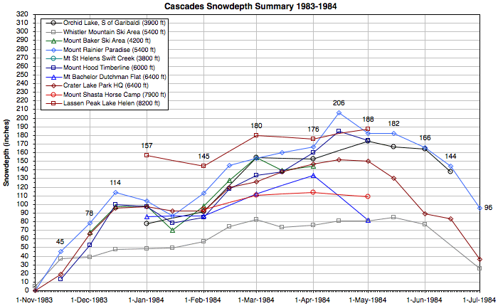
A few notes about the sites included in these graphs: • The Upper Squamish River telemetry site near Mount Cayley in BC was installed in 1989, and a snowdepth gauge was added in 1995. Prior to 1995, snowdepth has been estimated from snow water content. For seasons prior to 1989, data from the Orchid Lake monthly snow course south of Mount Garibaldi (which has somewhat greater average snowdepths) has been shown instead. No data is available for Orchid Lake prior to 1972 and for Whistler Mountain prior to 1973. • For Mount Baker Ski Area and Mount Hood Timberline Lodge, data is only available from November 15 to May 1 prior to the 2002-2003 season. Data is not available for Timberline Lodge prior to 1973, so for earlier seasons data from the Phlox Point monthly snow course just downhill from the lodge (with somewhat lower average snowdepths) has been shown instead. • The Mount Saint Helens Swift Creek SNOTEL site was installed in late 2002, and this location receives huge snowfalls depite it modest 3800 ft elevation. Prior to 2002, no snowdepth data is available on Mount Saint Helens since 1980. For 1980 and earlier, data from the Plains of Abraham monthly snow course on the NE side (which has very large average snowdepths) has been shown instead. • My records for Mount Bachelor Ski Area are incomplete prior to the 2002-2003 season. Temporarily, data from the nearby Dutchman Flat monthly snow course (which has similar elevation and snowdepth) has been substituted for earlier seasons. • The Mount Shasta hourly snowdepth telemetry site at 7600 ft in the Old Ski Bowl was installed in late 2002. Prior to that, data for Mount Shasta comes from a monthly snow course at 7900 ft near Horse Camp. Hourly snowdepth telemetry has been available at the lower Sand Flat site at 6800 ft on Shasta since 1998, but that is not plotted in these graphs. • For Lassen Peak Lake Helen, only monthly snow course data (January-May most years, but only February-April some years) is available prior to November 2003, when an hourly snowdepth telemetry site was installed. This snowdepth gauge typically reads slightly lower than the snow course, as it appears to be in a somewhat wind-affected location. |
||||||||||
Cascade Seasonal Snowdepth Leaders |
|||||||||||||
|
While researching the past decade's snow climatology throughout the Cascade Range, just for fun I decided to figure out which site had recorded the maximum snowdepth in the Cascades during each of those seasons. The annual leaders are listed in the table below. In general, sites with daily or hourly data have an advantage over monthly snow courses in this contest, since newly fallen snow settles rapidly after major storm cycles, and maximum snowdepths reached during mid-month could easily have settled 50-60" or more prior to an end-of-month measurement. Nevertheless, the monthly snow course site at Lake Helen on Lassen Peak has been the Cascades seasonal snowdepth leader more often than any other site during the past decade, even more than Mount Rainier Paradise. Note that the Lassen site was upgraded in Nov 2003 to include hourly snowdepth telemetry. What about the 2004-2005 season, should I risk making an early season prediction? Well, given the moderate El Niño conditions in the eastern Pacific Ocean, my guess is that Lassen Peak is quite likely to make it 3 in a row this year. January 15 Update: So far this season, Mount Shasta has recorded the greatest snowdepth with over 130" at the Old Ski Bowl, leading Lassen Peak by about 30". May 15 Update: Mount Shasta Old Ski Bowl reached a maximum snowdepth of 155" on March 29, while Lassen Peak recorded 174" during the monthly snow survey on March 31 (even though the Lassen snowdepth gauge only reached 148"). That makes it a three-peat for Lassen Peak as snowdepth leader. And predictions for 2005-2006: The promising shift to ENSO neutral and even weak La Niña conditions this season means that Lassen Peak is not a clear pre-season favorite to make it four in a row. I'm hoping that a site in Washington can hold the lead for the first time in 5 years. January 28 Update: Chinook Pass, WA, today became the first official measurement site in North America to reach 200" of snowdepth this season, and it holds a commanding lead of about 40" over its nearest rivals, Paradise and Timberline. Barring a lengthy data outage (which it is often plagued by), Chinook Pass is now the clear favorite to be this season's champ. If the ongoing wet weather pattern continues through February and March, it is likely to break 250" this season and even has an outside chance of hitting 300". |
|||||||||||||
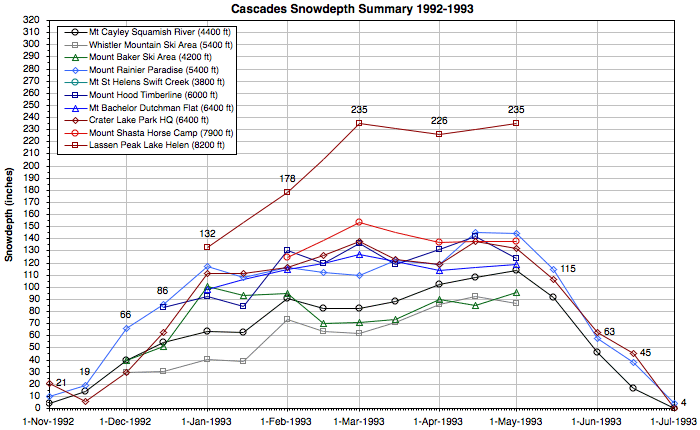
| Season | Snowdepth Leader | State / Prov. | Elevation | Maximum Snowdepth | Date of Maximum | Notes and Information | |||||||
| 2005-2006 | Chinook Pass | WA | 5600 ft | 225" | Feb 2, 2006 | Hourly NWAC snowdepth telemetry, seasonal maximum as of Feb 14, 2006. | |||||||
| 2004-2005 | Lassen Peak, Lake Helen | CA | 8200 ft | 174" | Mar 31, 2005 | Monthly snow course measurement; hourly snowdepth gauge reached maximum of 148" on March 29. | |||||||
| 2003-2004 | Lassen Peak, Lake Helen | CA | 8200 ft | 222" | Feb 28, 2004 | Monthly snow course measurement; hourly snowdepth gauge never exceeded 207". Mount Hood Timberline reached 204" on March 6, and Mount Shasta Old Ski Bowl hit 201" on February 26. | |||||||
| 2002-2003 | Lassen Peak, Lake Helen | CA | 8200 ft | 245" | May 1, 2003 | Monthly snow course measurement; hourly snowdepth gauge was not installed until Nov 2003. Lassen Chalet reached 206" on April 30, and Mount Shasta Old Ski Bowl hit 207" on April 29. | |||||||
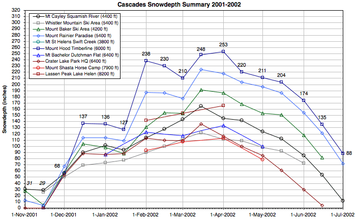
| 2001-2002 | Mount Hood, Timberline | OR | 6000 ft | 271" | Mar 19, 2002 | Hourly NWAC snowdepth telemetry. Chinook Pass reached 241" on March 19, while Mount Rainier Paradise reported 244" on March 20. | |||||||
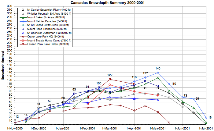
| 2000-2001 | Mount Rainier, Paradise | WA | 5400 ft | 145" | May 2, 2001 | Daily data. The seasonal snowfall of 524" was the lowest at Paradise since its 499" in 1991-92. | |||||||
| 1999-2000 | Chinook Pass | WA | 5600 ft | 211" | Mar 19, 2000 | Hourly NWAC snowdepth telemetry. Mount Rainier Paradise reached 205" on March 20. Mount Baker and Lassen Peak also approached 200", but daily data from Baker is not readily available and Lassen has only monthly snow course data. | |||||||
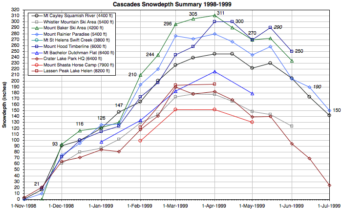
| 1998-1999 | Mount Baker Ski Area | WA | 4200 ft | 318" | Mar 30, 1999 | Mount Baker Ski Area set a world record with 1140" of seasonal snowfall. Mount Hood Timberline also exceeded 300" of snowdepth several times during the season, but daily data is not readily available. The monthly snow course sites at Cayuse/Chinook Pass and Orchid Lake (BC) also exceeded 300" near April 1. | |||||||
| 1997-1998 | Lassen Peak, Lake Helen | CA | 8200 ft | 250" | Mar 25, 1998 | Monthly snow course measurement; Lassen was far and away the Cascade snowdepth leader this season. | |||||||
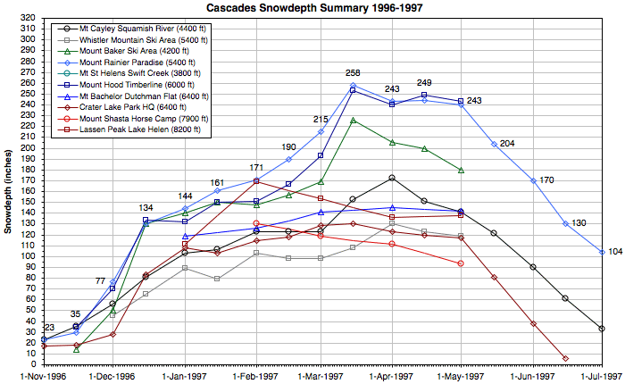
| 1996-1997 | Mount Rainier, Paradise | WA | 5400 ft | 268" | Mar 16, 1997 | Daily data. Paradise's snowfall of 938" was its largest in 23 years, but was soon surpassed by its 1033" in 1998-99. Mount Hood Timberline reached 253" on March 15, but daily data is not readily available. | |||||||
| 1995-1996 | Mount Hood, Timberline Lassen Peak, Lake Helen |
OR CA |
6000 ft 8200 ft |
178" 178" |
May 1, 1996 Apr 29, 1996 |
Semimonthly NWAC data at Timberline; daily data is not readily available, but maximum was probably close to 190". Monthly snow course measurement at Lassen, so maximum depth is difficult to accurately estimate. | |||||||
| 1994-1995 | Lassen Peak, Lake Helen | CA | 8200 ft | 287" | Mar 27, 1995 | Monthly snow course measurement; Lassen was far and away the Cascade snowdepth leader this season. | |||||||
| 1993-1994 | Chinook Pass | WA | 5600 ft | 176" | Feb 24, 1994 | Hourly NWAC snowdepth telemetry. Chinook Pass received over 40" of new snow during the previous day, while nearby Crystal Mtn got an astonishing 65"! Mount Baker Ski Area had 170" depth on March 1, but daily data is not readily available. | |||||||
| 1992-1993 | Lassen Peak, Lake Helen | CA | 8200 ft | 235" | Apr 27, 1995 | Monthly snow course measurement, also 235" on Feb 24; runaway Cascade snowdepth leader this season. | |||||||
|
Some interesting lessons from this data: In any given year, the highest snowdepth in the Cascade Range is almost always recorded at one of five sites: Mount Baker Ski Area, Mount Rainier Paradise, Chinook Pass, Mount Hood Timberline Lodge, or Lassen Peak Lake Helen (we'll call these the "Big Five"). These sites have average April 1 snowdepths of 14-15 ft, and most other sites simply have no chance of being the overall seasonal leader, although a few other sites such as Mount Shasta Old Ski Bowl or some sites in southwestern BC may hold the lead for short periods of time, especially in early season. A few monthly snow course sites in the WA Cascades (namely Jasper Pass, Easy Pass, Cayuse/Chinook Pass, and Blue Lake) have historically recorded average April 1 snowdepths greater than 15 ft, surpassing the Big Five, but unfortunately data is no longer taken at these locations. The current NWAC telemetry site at Chinook Pass is located about 250 ft higher than the old NRCS snow course, but unfortunately this valuable site is often plagued by lengthy data outages, sometimes spanning several months, and so the available data set is very incomplete. Sites in southwestern BC often have the largest early season snowdepths, especially the fairly new Upper Squamish River site, but they are usually passed by other sites farther south by January, if not earlier. The site with the highest average snowdepth in Canada, at Orchid Lake south of Garibaldi Park, is the only site in BC with average snowdepths comparable to the Big Five. Unfortunately, only monthly snow course data (January to June) is available for this site, which makes it difficult to record a true maximum snowdepth because of snow settlement between monthly measurements. Orchid Lake has not been the overall seasonal snowdepth leader since 1987. In almost every year, the Cascades snowdepth leader also records the most snowdepth of any measurement site in North America (and often the world), for several reasons. First of all, there are no measurement sites in the highest-snowfall areas of the Olympic, Coast, Chugach, and Saint Elias Mountains in WA, BC, and AK, which might otherwise easily surpass sites in the Cascades. Second, a few sites in the interior ranges (Columbia and Rocky Mountains) of BC, WY, UT, and CO do occasionally receive huge snowfalls of over 800" in a season, but the low density and moisture content nevertheless prevent the accumulation of snowpacks any deeper than about 15 ft, which is usually easily surpassed by the deepest Cascade sites. (During the record-setting Colorado winter of 1978-79, one site apparently recorded a greater snowdepth than any in the Cascades that year, as Wolf Creek Pass received 807" of snow and reached a maximum snowdepth of 251" on March 31, but the snowdepth data is highly suspect as the depth drops to only 156" the next day.) Third, the same weather pattern (typically El Niño related) which favors huge snowfalls in the Sierra Nevada of CA also produces huge snowfalls on Lassen Peak in the southernmost Cascades. The average snowdepths at Lake Helen on Lassen Peak are nearly 50% greater than Mount Shasta and over 20% greater than any official measurement site in the Sierra, which makes it unlikely for Shasta or any Sierra site to end up ahead of Lassen in any given year. Since snow course measurements began at these sites in 1930, Shasta has only exceeded Lassen's maximum snowdepth in a single season, 1981. To the best of my knowledge, the only official site in the Sierra Nevada to record maximum seasonal snowdepths greater than Lassen Peak since 1930 has been the Lake Lucille snow course just south of Lake Tahoe, which has done it only a handful of times during those 75 years. However, in a few very rare years, some other sites in the Sierra do record snowdepths greater than any in the Cascades. During the extraordinary 1994-1995 season, some ski areas in the Lake Tahoe region (in particular Kirkwood) reported snowdepths considerably greater than Lassen Peak, as much as 350-420" at their upper stations with seasonal snowfall exceeding 900". That same winter, Alyeska Ski Resort in Alaska also reached a snowdepth of 356" at its upper terminal with 918" of seasonal snowfall. These numbers seem fairly reliable, but most data from ski areas is unofficial and some of the data is also suspect, due to the significant financial incentives that ski area operators have for data manipulation and outright fabrication. According to the National Climate Extremes Committee, "Many ski areas have low credibility for accurate measurements since economic self-interest is served by reporting favorable snow conditions." For example, snowdepths recorded by official SNOTEL sites located at ski areas are often significantly less than those reported by the ski area's own measurements, even when both measurement sites are quite near each other and at similar elevation. Ski areas in Colorado and California (i.e. near Lake Tahoe) appear to be particularly susceptible to these issues, perhaps due to the heavy concentration of ski areas in those two regions and the resulting intense competition for skier dollars. In contrast, ski areas in the Pacific Northwest generally do report snowdepths which are identical (or close) to those from automated telemetry sites. Note added January 2005: Could the 2004-2005 season be headed for a repeat of the 1994-1995 anomaly? A pair of huge storm cycles from December 26-January 3 and January 7-12 have dumped 12-20 ft of new snowfall at higher elevations of the Sierra Nevada, rapidly building the deepest snow bases in North America. Meanwhile, Shasta and Lassen received "only" about 9-10 ft of snowfall from the same storms, falling far behind the Sierra in snowdepth. As of January 12, most Lake Tahoe ski areas (plus Mammoth Mountain farther south) were reporting base depths of 14-15 ft at their mid or upper stations, topped by Kirkwood's astounding 264" upper snowdepth with about 435" of snowfall this season. Among official measurement sites, the Leavitt Lake SNOTEL site at 9600 ft near Sonora Pass appears to be the leader with a maximum snowdepth of 176". The Cascades' snowdepth leader thus far is Mount Shasta with a maximum depth of over 130" in the Old Ski Bowl, followed by Lassen Peak Lake Helen with about 100". It would certainly require a major shift in the weather pattern throughout the rest of the winter for the Cascades to have any hope of catching up to the Sierra snowdepths this season. May 15, 2005, Update: The Cascades never did catch up to the Sierra this season, despite continued heavy snowfall in the CA Cascades. Mount Shasta Old Ski Bowl reached a maximum snowdepth of 155" on March 29, while Lassen Peak recorded 174" during the monthly snow survey on March 31. In the Sierra, the Leavitt Lake SNOTEL site reached 216" on March 24, still the most among official measurement sites. Alpine Meadows Ski Area reached 226" at mid-mountain on March 29, and Kirkwood's upper base depth reached 220" on March 28 (far short of its January maximum), with seasonal snowfall of 804" as of May 1. No measurement site in the Cascades recorded over 500" of snowfall this season. |
| Ratings and Brief Summaries for the 1994-2005 Cascade Snow Seasons | |||||||||||||||||
|
|||||||||||||||||
|
For the purposes of these seasonal ratings, the Cascade Range has been divided into six major
regions, see below. Note that Northern WA as defined here is roughly from Mount Baker to Snoqualmie Pass, while
Northern OR is from Mount Hood to Mount Bachelor. Several factors are considered in determining the seasonal
rating for each region. Most important are the total snowfall and maximum snowdepth at several key measurement
sites within the region, but the length of the season is also a factor. Seasons with significant early snowfall
(enough to open ski areas and allow access to popular backcountry areas) are rated higher than other seasons
which have comparable total snowfall but late starts. Credit is also given to seasons where the snowpack lasts
longer than normal into late spring and summer. Each season's Overall Rating for the entire Cascade Range is an
average of the six regional ratings. See the Cascades El Niño / La
Niña page for an explanation of the listed ENSO status and an analysis of ENSO effects on Cascade
snowfall and snowdepth. |
|||||||||||||||||
|
|||||||||||||||||
|
The 2005-2006 season began with a bang, as heavy snowfall in late October and early November provided
many ski areas in BC, WA, and OR with their earliest openings since 1994. Lengthy two-week dry spells in late
November and early December, followed by a warm deluge of rain around Christmas, withered away the snowpack and
produced panicked memories of last season. But since late December, a sustained pattern of very wet weather and
generally below normal temperatures has brought 6 weeks of very heavy snowfall, building a deep snowpack which
by early February reached 130-180% of normal throughout the range. This is shaping up as the best snow season
overall in the Cascades since 2001-2002, perhaps even since the huge record year of 1998-99. NOTE: These are preliminary ratings as of Feb 14, 2006, and are subject to change based on conditions during the spring and early summer. The final seasonal summary will be written in summer 2006. See the detailed 2005-2006 Snow Season Report for ongoing updates during the current season. |
||||||||||||||||
|
|||||||||||||||||
|
The 2004-2005 season will long be remembered for record low late-winter snowdepths in BC, WA, and
OR, contrasted with plentiful snowfalls in the CA Cascades and huge near-record snowfalls farther south in the Sierra
Nevada. Truly one of the most unusual and exceptional seasons in many decades. The sustained heavy snowfall from
mid-March to mid-April in BC, WA, and OR certainly saved the spring ski season from complete disaster in those areas,
but came too late to salvage the season at most ski areas. At high elevations above 6000-7000 ft throughout the
range, heavy snowfall in May maintained significant snowdepths into late spring. Mount Shasta enjoyed its best spring
and summer ski mountaineering season since 1997-98, exceeding even the past two years which had very deep April/May
snowpacks at the measurement sites. Overall, northern CA enjoyed its third straight above normal season, while BC,
WA, and northern OR suffered through their worst snow year since 1976-77, or even since 1940-41 at locations like Mt
Rainier and Mt Hood. See the detailed 2004-2005 Snow Season Report for extensive information and semimonthly snowdepth data. |
||||||||||||||||
|
|||||||||||||||||
|
This was a fairly typical season in the Cascades, and overall it was slightly better than average.
The season began roughly on schedule with major snowfall in late November, continuing in force throughout December.
By January 1, all areas had above normal snowdepths, as much as double normal in southern OR and northern CA. Above
normal snowfall continued during January and February, but March and April were unusually warm and dry throughout the
range. The best regions this season were farthest south, as the area from Mount McLoughlin to Lassen Peak built a
huge snowpack which peaked about a month early, reaching nearly 200% of normal by March 1. Areas farther north
reached peak snowdepths in the first week of March, while a few sites in WA and BC peaked closer to the normal time
in the fourth week of March. The very warm spring weather rapidly melted the huge snowpack at the southern end of
the range, limiting the spring and early summer ski season to a fairly normal length, while in BC and WA a return to
frequent stormy weather in May/June helped extend the spring/summer ski season at high elevations despite the more
limited snowpack. See the detailed 2003-2004 Snow Season Report for extensive information and semimonthly snowdepth data. |
||||||||||||||||
|
|||||||||||||||||
|
This was a very unusual season in the Cascades, marked by a bizarre pattern of lengthy dry spells
and huge snowfalls. It began with prolonged drought from October through early December, followed by tremendous
near-record snowfalls until New Years Day, especially in California. But the heart of the winter season in
January and February had well below-normal snowfall throughout the range, with only a few scattered storm
cycles as snowpacks dwindled to half of normal depths in Oregon and Washington. However, the finish was quite
spectacular, with March and April again having near-record snowfalls especially in British Columbia and
California. Snowdepths generally peaked during these storms in early to mid April, at values near or above
normal. Snowdepths in northern California peaked exceptionally late near May 1 and were the largest there in 5
years, comparable to the huge El Niño year of 1997-98. Overall, the 2002-2003 season was average to
spectacular at higher elevations, but quite dismal at low elevations throughout the Cascade Range. See the detailed 2002-2003 Snow Season Report for extensive information and snowdepth data. |
||||||||||||||||
|
|||||||||||||||||
|
The 2001-2002 season was a fine one throughout the majority of the Cascade Range, especially at
lower elevations which have often suffered in recent years. Winter snows arrived on schedule in November and
consistently cold temperatures throughout much of the winter produced numerous excellent powder days. There was
a significant period of rain in late December and the first week of the New Year, but heavy snowfall returned
for the second half of January. March was also very snowy, with most sites reaching a seasonal maximum
snowdepth late in the month. Deep snows accumulated from BC to southern Oregon, most notably in the region from
Mount Rainier to Mount Hood and Mount Bachelor. The only part of the Cascades which missed out on the fun was
northern California, which was slightly below normal for snowfall and snowdepth throughout the season. |
||||||||||||||||
|
|||||||||||||||||
|
This was an exceptionally poor snow season in the Cascades, a severe drought year after four
straight good to great years. The season got off to a generally dry start, with only BC building acceptable
snowdepths before the New Year. The overall pattern continued throughout the winter, with extended periods of
high pressure and dry conditions interspersed with rare and brief storm cycles. The southern end of the range
enjoyed a big February, with 10-12 ft of snowfall bringing depths close to normal on Shasta and Lassen, but then
it rapidly warmed and the snowpack faded after that. February and most of March were fairly dry farther north,
but the arrival of spring finally brought big snowfalls especially in WA and BC, building snowdepths to a very
tardy seasonal maximum in late April and early May at higher elevations. Oregon south of Mount Hood largely
missed out on the late season boost, and this region suffered the most during the year, with snowfall and
snowdepths less than half of normal. Overall, 2000-2001 was the worst snow year in the Cascades since at least
1991-92, but it fell short of being a complete disaster like the 1976-77 and 1980-81 seasons. |
||||||||||||||||
|
|||||||||||||||||
|
This was a fairly typical, but somewhat above-normal, snow year in the Cascades. Although La
Niña conditions strengthened throughout the fall and winter, the record snowfalls of 1998-1999 were not
to be repeated this year. Heavy snowfall arrived on schedule in November in BC, but the rest of the range was
quite dry until December. Major storm cycles during the first halves of December and January were followed by
lengthy dry periods during the latter halves of those months. February brought huge storms to southern OR and
northern CA, building snowdepths to a premature seasonal maximum by March 1. The storm track shifted farther
north for the rest of March, and sites in WA and BC reached their seasonal maximum during the last week of
March. Seasonal snowfall and maximum snowdepths were generally about 10-15% above normal throughout most of the
Cascade Range, except for Oregon where snowfall and April snowdepths were slightly below normal. |
||||||||||||||||
|
|||||||||||||||||
|
Wow, 1998-99 was an absolutely unbelievable, truly memorable, record-setting snow year throughout
the Cascades of BC, WA, and OR, unlike anything seen in a quarter-century. In northern CA, this was merely a
very good year, well above normal but far short of the huge snows of 1997-98. Following the previous seasons's
extreme El Niño conditions, tropical water in the Pacific rapidly cooled and the pendulum swung into the
La Niña phase by summer 1998, strengthening throughout the fall and winter. Heavy Cascade snows began on
schedule in mid-November and continued throughout December and January. The real jackpot was hit in February,
as snowfalls for the month exceeded 150-200" at many locations and Mount Baker Ski Area set a monthly
snowfall record of 304". So much snow fell there that the ski area had to shut down for several days in
mid-February to dig out the lifts and widen the plowed highway. Cold weather dominated throughout the winter,
with numerous epic powder days and very little mountain rainfall except in December. Lowland rainfall was
nearly constant during the winter, as Seattle recorded almost 90 consecutive days with measurable precipitation.
Heavy mountain snows continued into March especially in WA and BC, bringing snowdepths to a huge crescendo by
the end of the month. Many mountain buildings and automated snow measurement sites in BC and WA were
completely buried during March by the 20-30 ft deep snowpack. Moderate snowfall continued during April and
until mid-May. Overall, this was the best Cascades snow year since at least 1973-74. Many sites in BC, WA, and
northern OR set all-time records for snowfall and snowdepth during the 1998-99 season, including Mount Baker Ski
Area's new world record of 1140" of snowfall. Mount Rainier Paradise exceeded 1000" for the first
time in 25 years, while Crater Lake's 667" was its most in 28 years. |
||||||||||||||||
|
|||||||||||||||||
|
Info about the season . . . to be written soon. |
||||||||||||||||
|
|||||||||||||||||
|
Info about the season . . . to be written soon. |
||||||||||||||||
|
|||||||||||||||||
|
Info about the season . . . to be written soon. |
||||||||||||||||
|
|||||||||||||||||
|
Info about the season . . . to be written soon. |
||||||||||||||||