Cascade Snowfall and Snowdepth 2005-2006
|
|
|
2005-2006 Snow Season Summary (last updated April 2006)
|
|
See the main Cascade Snowfall and Snowdepth page for historical snowpack info.
Detailed Snow Season Reports: 2005-2006, 2004-2005,
2003-2004, 2002-2003; see also
Previous Seasons, Normals & Info, and
Cascades El Niño / La Niña
NEW: Historical NWAC Snowdepth Data & Plots and
Paradise & Crater Lake Snowfall/Snowdepth Plots
|
Season Summary as of March 1, 2006:
The 2005-2006 season got off to a great start with cold temperatures and heavy snowfall from late
October into mid-November, building a snowpack well above normal and helping to erase memories of last year's
misery. Most ski areas in southwestern BC, the WA Cascades, and Mount Hood opened in early November, their
earliest openings since 1994 and for some areas their earliest ever. By November 15, snowdepths were 2-6 ft at
many mountain locations in BC, WA, and OR, about 200-300% or more of normal. High pressure brought largely clear
skies for the next ten days, settling and shrinking the snowpack, but then another cycle of very cold storms
brought several more feet of snow through December 4, maintaining snowdepths well above normal even at lower
elevations.
Another strong high pressure system then brought two more weeks of sunshine, further settling the
snowpack and diminishing snowdepths to below normal in BC, WA, northern CA by December 15, while Oregon remained
somewhat above normal. When precipitation finally returned on Dec 18, it was warm, too warm and too wet. Heavy
rainfall battered the Northwest through Christmas Day, sending the snowpack throughout the Cascade Range
plummeting down the drain towards 50% of normal or less. The situation looked bleak, almost hopeless.
Unexpectedly, on Dec 26 the weather pattern shifted to a cool and wet westerly flow, with the jet
stream aimed squarely at the Pacific NW and carrying an unrelenting series of powerful storms. This excellent
situation would remain in place with only a few minor interruptions for the next 6 weeks. The final week of 2005
brought 3-5 ft of new snow throughout the mountains of the Pacific NW, with another 2-4 ft during the first days
of 2006. A brief warmup brought heavy rain on Jan 6-7, but cool weather quickly returned and an intense
storm cycle dumped 4-9 ft of snow over the next week, capped by 111" in 7 days at Mt Baker. The subsequent
storms were less sustained, but still dropped 2-5 ft atop the rapidly deepening snowpack during the third week
of January. A brief high-pressure window brought 2 days of sun on Jan 24-25, but then the storms returned with
renewed vigor, burying the mountains under 6-12 ft of additional snow over the next 11 days. By February 1,
snowdepths had built to 9-15 ft (roughly 130-180% of normal) at most measurement sites in the Cascades, topped
by well over 200" at Chinook Pass. At least one site has set a new record for February 1 snowdepth,
Fourmile Lake near Mount McLoughlin with 105", over 200% of normal.
During January 2006, Whistler set a new record for snowfall in any calendar month with 185", while
the 269" at Mount Baker Ski Area was their 2nd-most ever for a month behind Feb 1999. The 239" at
Mount Rainier Paradise and the 173" at Snoqualmie Pass were the most in any January since 1972 and 1971
respectively.
The intense storm cycle and heavy snowfall continued into February, with 2-5 more ft of snow
falling throughout the Cascades before strong high pressure returned on February 5. The West Coast basked in
sunshine for the nest week while the jet stream aimed due north into south-central Alaska, dropping over 11 ft
of snowfall in only 7 days at sites such as Alyeska Ski Resort. A weak system finally brought a few inches of
snow to the Cascades on Feb 13-15, with isolated amounts of nearly 10" at Snoqualmie Pass and Mount Hood.
Overall during the first half of the month, snowdepths have generally decreased 5-20" at most sites in the
Cascades, but as of February 15 the snowpack remains at 100-150% of normal throughout the range, except on
Lassen Peak where the snowpack is well below normal especially at mid-elevations.
As the second half of February began, high pressure and a strong northerly flow around an Omega
block delivered an Arctic blast to much of the WA and OR Cascades, with temps dropping as low as -10 °F
at many mountain sites, the coldest in about 10 years. Meanwhile, the southern half of the Omega block (a cutoff
low off the CA coast) brought 1-2 ft of champagne powder (3-5% density) to the CA Cascades and Sierra Nevada. An
overall moist weather pattern returned in late February, starting with a strong frontal system that dropped 2-3
ft of snow on the WA Cascades and 1 ft on Mount Hood on Feb 23-24, followed by a quick system which brought 1-2
ft to the BC Cascades and Mount Baker on Feb 26-27. A powerful system closing out the month aimed southward at
CA, dumping 2-3 ft of snow on the southern OR and CA Cascades and Sierra Nevada. Another pair of storm systems
ushering in March are likely to dump 2-4 ft more of snow on that region.
As of March 1, the snowpack is roughly 100-150% normal throughout the length of the Cascades,
except for a few scattered sites which are somewhat below normal. Snowdepths at mid-elevations near treeline are
generally 10-15 ft throughout the range, topped by Chinook Pass which is reporting over 200". This is in
sharp contrast to last year, when a series of very warm and wet Pineapple Expresses interspersed with lengthy
periods of dryness had devastated the snowpack in BC, WA, and OR. By March 1, 2005, the snowpack at most sites
in southwest BC, WA, and northern OR had shrunk to record lows, only 0-30% of normal with barely a few feet of
snow and extensive patches of bare ground on sunny aspects. Southern OR was slightly better off at 40-50% of
normal, while only northern CA remained near normal or slightly above (see 2004-2005
season report). What a relief this year is, it's great to finally enjoy a season which is above-average
throughout the entire Cascade Range.
See the semimonthly reports below for a detailed discussion of the season . . .
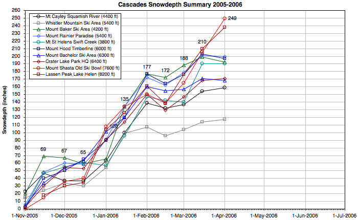
The graph and table below summarize snowdepths at 10 important sites throughout the entire Cascade
Range during the 2005-2006 season (record lows are shown in red in the table).
These high-snowdepth sites are all located about 1000 ft below timberline and are representative of conditions
in the subalpine regions on favored slopes (not rain-shadowed areas). Place your mouse over the links below to
compare the same plot for previous seasons and with normal values for the period of record (this only works if
you have a JavaScript-enabled browser). An archive of the semimonthly snowdepth stats and commentaries during
the current season can be found below the graph.
Mouse-over links to change season graph, click to load season report:
2002-2003 |
2003-2004 |
2004-2005 |
2005-2006 |
Normals
|
|
|
|
---- BRITISH COLUMBIA ---- |
---------- WASHINGTON ---------- |
-------------- OREGON -------------- |
------ CALIFORNIA ------ |
|
|
Mt Cayley
Squamish R.
4400 ft |
|
Whistler Mtn
Ski Area
5400 ft |
|
Mt Baker
Ski Area
4200 ft |
|
Mt Rainier
Paradise
5400 ft |
|
Mt St Helens
Swift Creek
3800 ft |
|
Mt Hood
Timberline
6000 ft |
|
Mt Bachelor
Ski Area
6300 ft |
|
Crater Lake
Park HQ
6400 ft |
|
Mt Shasta
Old Ski Bowl
7600 ft |
|
Lassen Peak
Lake Helen
8200 ft |
| 01 Nov 2005 |
| 23" |
|
| 15" |
|
| 20" |
|
| 6" |
|
| 3" |
|
| 2" |
|
| 5" |
|
| 3" |
|
| 0" |
|
| — |
|
| 15 Nov 2005 |
47" |
24" |
69" |
48" |
47" |
40" |
34" |
30" |
15" |
18" |
| 01 Dec 2005 |
37" |
34" |
67" |
60" |
55" |
50" |
54" |
54" |
36" |
30" |
| 15 Dec 2005 |
37" |
30" |
59" |
58" |
61" |
65" |
63" |
53" |
40" |
35" |
| 01 Jan 2006 |
63" |
54" |
66" |
91" |
57" |
90" |
101" |
90" |
108" |
104" |
| 15 Jan 2006 |
100" |
99" |
134" |
135" |
96" |
120" |
120" |
114" |
134" |
126" |
| 01 Feb 2006 |
139" |
107" |
177" |
172" |
147" |
177" |
160" |
150" |
150" |
161" |
| 15 Feb 2006 |
132" |
96" |
172" |
162" |
142" |
164" |
155" |
129" |
139" |
138" |
| 01 Mar 2006 |
137" |
104" |
188" |
179" |
140" |
176" |
157" |
147" |
165" |
176" |
| 15 Mar 2006 |
154" |
114" |
199" |
201" |
190" |
203" |
171" |
168" |
205" |
210" |
| 01 Apr 2006 |
— |
117" |
192" |
200" |
190" |
197" |
168" |
171" |
249" |
238" |
| 15 Apr 2006 |
— |
— |
— |
— |
— |
— |
— |
— |
— |
— |
| 01 May 2006 |
— |
— |
— |
— |
— |
— |
— |
— |
— |
— |
| 15 May 2006 |
— |
— |
— |
— |
— |
— |
— |
— |
— |
— |
| 01 Jun 2006 |
— |
— |
— |
— |
— |
— |
— |
— |
— |
— |
| 15 Jun 2006 |
— |
— |
— |
— |
— |
— |
— |
— |
— |
— |
| 01 Jul 2006 |
— |
— |
— |
— |
— |
— |
— |
— |
— |
— |
| |
| Seasonal Max |
171" |
119" |
210" |
215" |
204" |
208" |
177" |
172" |
249" |
238" |
| Date of Max |
08 Mar
2006 |
07 Mar
2006 |
10 Mar
2006 |
10 Mar
2006 |
22 Mar
2006 |
12 Mar
2006 |
10 Mar
2006 |
17 Mar
2006 |
01 Apr
2006 |
01 Apr
2006 |
|
|
Semimonthly Snowfall and Snowdepth Reports for the 2005-2006 Season
|
|
|
The tables below show semimonthly snowfall and snowdepth info at 47 measurement sites along the
entire length of the Cascade Range, primarily on or near the Cascade volcanoes. The frequency of data
collection varies at these sites, from hourly automated telemetry to manual daily or monthly measurements. Note
that multiple sites or data sources are found at several of these locations, and their data values typically
differ slightly from each other. The codes used below for Data Frequency read as follows: H = Hourly Snowdepth
Telemetry, H* = Hourly Snow-Water Telemetry (snowdepth estimated), D = Daily Manual Snowdepth, M = Monthly
Manual Snowdepth (Jan 1 - June 1 or less), A = April 1 Manual Snowdepth Only.
See Information about Cascade Snowdepth Measurement Sites for more
details about these sites including normal snowdepths throughout the season.
The following measurement sites have been added to this list for the 2005-2006 season.
The NRCS continues its program of adding
snowdepth gauges to existing SNOTEL sites, including several very useful sites on or near the Cascade volcanoes this
season.
|
State /
Prov. |
Measurement Site Location |
Elevation |
|
Data Source
and Frequency |
|
Information and Notes |
|
| WA |
Lyman Lake
(NE of Glacier Peak) | 5900 ft |
NRCS |
H | Snowdepth gauge installed on existing SNOTEL site, added to list |
| Mt Saint Helens,
Sheep Canyon (W side) | 4000 ft |
NRCS |
H | Snowdepth gauge installed on existing SNOTEL site, added to list |
| OR |
Diamond Lake
(west of Mt Thielsen) | 5300 ft |
NRCS |
H | Snowdepth gauge installed on existing SNOTEL site (in 2004), added to list |
| Pelican Butte,
Cold Springs (NW side) | 6100 ft |
NRCS |
H | Snowdepth gauge installed on existing SNOTEL site, added to list |
|
|
Snowfall and Snowdepth Info (15 November 2005)
|
|
The 2005-2006 snow season again received a very promising launch . . .
Archived data for 15 Nov 2005 will be inserted here soon . . .
|
|
|
(Italicized numbers are estimated, grayed values are no longer current)
|
State /
Prov. |
Measurement Site Location |
Elevation |
|
Data Source
and Frequency |
|
Date of
Measurement |
|
Snow
Depth |
|
Percent of
Normal |
|
Seasonal
Snowfall |
|
Year to Date
Max. Depth |
| BC |
Tenquille Lake (east of Mt Meager) | 5500 ft |
BC RFC |
|
H, M | |
" |
|
|
|
" |
|
", |
| Upper Squamish River (NW of Cayley) | 4400 ft |
BC RFC |
H | |
" |
|
" |
", |
| Callaghan Creek (east of Mt Cayley) | 3400 ft |
BC RFC |
M | |
" |
|
" |
", |
| Whistler Mtn, Pig Alley (N of Garibaldi) | 5400 ft |
Ski Area |
D | |
" |
|
" |
", |
| Orchid Lake (south of Mt Garibaldi) | 3900 ft |
BC RFC |
M | |
" |
|
" |
", |
| Grouse Mountain (North Vancouver) | 3700 ft |
Ski Area |
D | |
" |
|
" |
", |
| WA |
Mt Baker Ski Area (NE of Mt Baker) | 4200 ft |
NWAC |
H, D | |
" |
|
" |
", |
| Mt Baker, Wells Creek (north side) | 4200 ft |
NRCS |
H | |
" |
|
" |
", |
| Mt Baker, MF Nooksack (NW side) | 5000 ft |
NRCS |
H | |
" |
|
" |
", |
| Mt Baker, Elbow Lake (SW side) | 3200 ft |
NRCS |
H | |
" |
|
" |
", |
| Rainy Pass (far NE of Glacier Peak) | 4800 ft |
NRCS |
H | |
" |
|
" |
", |
| Park Creek Ridge (E of Cascade Pass) | 4600 ft |
NRCS |
H | |
" |
|
" |
", |
| Lyman Lake (NE of Glacier Peak) | 5900 ft |
NRCS |
H | |
" |
|
" |
", |
| Stevens Pass [see also NRCS site] | 4000 ft |
NWAC |
H, D | |
" |
|
" |
", |
| Snoqualmie Pass | 3000 ft |
NWAC |
H, D | |
" |
|
" |
", |
| Crystal Mtn Ski Area (NE of Rainier) | 4400 ft |
NWAC |
H, D | |
" |
|
" |
", |
| Chinook Pass (east of Mt Rainier) | 5600 ft |
NWAC |
H | |
" |
|
" |
", |
| Mt Rainier, Sunrise (NE side) | 6400 ft |
NWAC |
H | |
" |
|
" |
", |
| Mt Rainier, Paradise (south side) | 5400 ft |
NWAC |
H, D | |
" |
|
" |
", |
| White Pass [see also NRCS site] | 4500 ft |
NWAC |
H, D | |
" |
|
" |
", |
| Pigtail Peak (N of Goat Rocks) | 5900 ft |
NRCS |
H | |
" |
|
" |
", |
| Mt Saint Helens, Sheep Canyon (W side) | 4000 ft |
NRCS |
H | |
" |
|
" |
", |
| Mt Saint Helens, Swift Creek (S side) | 3800 ft |
NRCS |
H | |
" |
|
" |
", |
| Mt Saint Helens, June Lake (SE side) | 3300 ft |
NRCS |
H | |
" |
|
" |
", |
| OR |
Mt Hood, Timberline Lodge (S side) | 6000 ft |
NWAC |
H, D | |
" |
|
" |
", |
| Mt Hood Test Site (south side) | 5400 ft |
NRCS |
H | |
" |
|
" |
", |
| Mt Hood, Government Camp (SW side) | 4000 ft |
NCDC |
D | |
" |
|
" |
", |
| Mt Hood Meadows Ski Area (SE side) | 5200 ft |
NWAC |
H, D | |
" |
|
" |
", |
| Hogg Pass (near Santiam Pass) | 4800 ft |
NRCS |
H | |
" |
|
" |
", |
| McKenzie (NW of Three Sisters) | 4800 ft |
NRCS |
H | |
" |
|
" |
", |
| Mt Bachelor Ski Area (north side) | 6300 ft |
Ski Area |
D | |
" |
|
" |
", |
| Cascade Summit (NE of Diamond Peak) | 4900 ft |
NRCS |
H | |
" |
|
" |
", |
| Diamond Lake (NE of Mt Bailey) | 5300 ft |
NRCS |
H | |
" |
|
" |
", |
| Crater Lake, Caldera Rim (SW side) | 7100 ft |
DRI |
H | |
" |
|
" |
", |
| Crater Lake, Park HQ (SW side) | 6400 ft |
NPS |
H, D | |
" |
|
" |
", |
| Crater Lake, Annie Springs (SW side) | 6000 ft |
NRCS |
H | |
" |
|
" |
", |
| Pelican Butte, Cold Springs (NW side) | 6100 ft |
NRCS |
H | |
" |
|
" |
", |
| Fourmile Lake (east of Mt McLoughlin) | 6000 ft |
NRCS |
H | |
" |
|
" |
", |
| Mt McLoughlin, Billie Creek (SE side) | 5300 ft |
NRCS |
H | |
" |
|
" |
", |
| CA |
Medicine Lake (west side of caldera) | 6700 ft |
CCSS |
H*, A | |
" |
|
" |
", |
| Mt Shasta, Horse Camp (SW side) | 7900 ft |
CCSS |
M | |
" |
|
" |
", |
| Mt Shasta, Old Ski Bowl (south side) | 7600 ft |
MSAC |
H | |
" |
|
" |
", |
| Mt Shasta, Sand Flat (SW side) | 6800 ft |
CCSS |
H, M | |
" |
|
" |
", |
| Mt Shasta, Brewer Creek (east side) | 6200 ft |
CCSS |
M | |
" |
|
" |
", |
| Lassen Peak, Manzanita Lake (NW side) | 5800 ft |
NPS |
D | |
" |
|
" |
", |
| Lassen Peak, Lake Helen (south side) | 8200 ft |
CCSS |
H, M | |
" |
|
" |
", |
| Lassen Chalet (SW of Lassen Peak) | 6700 ft |
NPS |
D | |
" |
|
" |
", |
|
|
Snowfall and Snowdepth Info (01 December 2005)
|
|
Text narrative to be written . . .
Archived data for 01 Dec 2005 will be inserted here soon . . .
|
|
|
(Italicized numbers are estimated, grayed values are no longer current)
|
State /
Prov. |
Measurement Site Location |
Elevation |
|
Data Source
and Frequency |
|
Date of
Measurement |
|
Snow
Depth |
|
Percent of
Normal |
|
Seasonal
Snowfall |
|
Year to Date
Max. Depth |
| BC |
Tenquille Lake (east of Mt Meager) | 5500 ft |
BC RFC |
|
H, M | |
" |
|
|
|
" |
|
", |
| Upper Squamish River (NW of Cayley) | 4400 ft |
BC RFC |
H | |
" |
|
" |
", |
| Callaghan Creek (east of Mt Cayley) | 3400 ft |
BC RFC |
M | |
" |
|
" |
", |
| Whistler Mtn, Pig Alley (N of Garibaldi) | 5400 ft |
Ski Area |
D | |
" |
|
" |
", |
| Orchid Lake (south of Mt Garibaldi) | 3900 ft |
BC RFC |
M | |
" |
|
" |
", |
| Grouse Mountain (North Vancouver) | 3700 ft |
Ski Area |
D | |
" |
|
" |
", |
| WA |
Mt Baker Ski Area (NE of Mt Baker) | 4200 ft |
NWAC |
H, D | |
" |
|
" |
", |
| Mt Baker, Wells Creek (north side) | 4200 ft |
NRCS |
H | |
" |
|
" |
", |
| Mt Baker, MF Nooksack (NW side) | 5000 ft |
NRCS |
H | |
" |
|
" |
", |
| Mt Baker, Elbow Lake (SW side) | 3200 ft |
NRCS |
H | |
" |
|
" |
", |
| Rainy Pass (far NE of Glacier Peak) | 4800 ft |
NRCS |
H | |
" |
|
" |
", |
| Park Creek Ridge (E of Cascade Pass) | 4600 ft |
NRCS |
H | |
" |
|
" |
", |
| Lyman Lake (NE of Glacier Peak) | 5900 ft |
NRCS |
H | |
" |
|
" |
", |
| Stevens Pass [see also NRCS site] | 4000 ft |
NWAC |
H, D | |
" |
|
" |
", |
| Snoqualmie Pass | 3000 ft |
NWAC |
H, D | |
" |
|
" |
", |
| Crystal Mtn Ski Area (NE of Rainier) | 4400 ft |
NWAC |
H, D | |
" |
|
" |
", |
| Chinook Pass (east of Mt Rainier) | 5600 ft |
NWAC |
H | |
" |
|
" |
", |
| Mt Rainier, Sunrise (NE side) | 6400 ft |
NWAC |
H | |
" |
|
" |
", |
| Mt Rainier, Paradise (south side) | 5400 ft |
NWAC |
H, D | |
" |
|
" |
", |
| White Pass [see also NRCS site] | 4500 ft |
NWAC |
H, D | |
" |
|
" |
", |
| Pigtail Peak (N of Goat Rocks) | 5900 ft |
NRCS |
H | |
" |
|
" |
", |
| Mt Saint Helens, Sheep Canyon (W side) | 4000 ft |
NRCS |
H | |
" |
|
" |
", |
| Mt Saint Helens, Swift Creek (S side) | 3800 ft |
NRCS |
H | |
" |
|
" |
", |
| Mt Saint Helens, June Lake (SE side) | 3300 ft |
NRCS |
H | |
" |
|
" |
", |
| OR |
Mt Hood, Timberline Lodge (S side) | 6000 ft |
NWAC |
H, D | |
" |
|
" |
", |
| Mt Hood Test Site (south side) | 5400 ft |
NRCS |
H | |
" |
|
" |
", |
| Mt Hood, Government Camp (SW side) | 4000 ft |
NCDC |
D | |
" |
|
" |
", |
| Mt Hood Meadows Ski Area (SE side) | 5200 ft |
NWAC |
H, D | |
" |
|
" |
", |
| Hogg Pass (near Santiam Pass) | 4800 ft |
NRCS |
H | |
" |
|
" |
", |
| McKenzie (NW of Three Sisters) | 4800 ft |
NRCS |
H | |
" |
|
" |
", |
| Mt Bachelor Ski Area (north side) | 6300 ft |
Ski Area |
D | |
" |
|
" |
", |
| Cascade Summit (NE of Diamond Peak) | 4900 ft |
NRCS |
H | |
" |
|
" |
", |
| Diamond Lake (NE of Mt Bailey) | 5300 ft |
NRCS |
H | |
" |
|
" |
", |
| Crater Lake, Caldera Rim (SW side) | 7100 ft |
DRI |
H | |
" |
|
" |
", |
| Crater Lake, Park HQ (SW side) | 6400 ft |
NPS |
H, D | |
" |
|
" |
", |
| Crater Lake, Annie Springs (SW side) | 6000 ft |
NRCS |
H | |
" |
|
" |
", |
| Pelican Butte, Cold Springs (NW side) | 6100 ft |
NRCS |
H | |
" |
|
" |
", |
| Fourmile Lake (east of Mt McLoughlin) | 6000 ft |
NRCS |
H | |
" |
|
" |
", |
| Mt McLoughlin, Billie Creek (SE side) | 5300 ft |
NRCS |
H | |
" |
|
" |
", |
| CA |
Medicine Lake (west side of caldera) | 6700 ft |
CCSS |
H*, A | |
" |
|
" |
", |
| Mt Shasta, Horse Camp (SW side) | 7900 ft |
CCSS |
M | |
" |
|
" |
", |
| Mt Shasta, Old Ski Bowl (south side) | 7600 ft |
MSAC |
H | |
" |
|
" |
", |
| Mt Shasta, Sand Flat (SW side) | 6800 ft |
CCSS |
H, M | |
" |
|
" |
", |
| Mt Shasta, Brewer Creek (east side) | 6200 ft |
CCSS |
M | |
" |
|
" |
", |
| Lassen Peak, Manzanita Lake (NW side) | 5800 ft |
NPS |
D | |
" |
|
" |
", |
| Lassen Peak, Lake Helen (south side) | 8200 ft |
CCSS |
H, M | |
" |
|
" |
", |
| Lassen Chalet (SW of Lassen Peak) | 6700 ft |
NPS |
D | |
" |
|
" |
", |
|
|
Snowfall and Snowdepth Info (15 December 2005)
|
|
Text narrative to be written . . .
Archived data for 15 Dec 2005 will be inserted here soon . . .
|
|
|
(Italicized numbers are estimated, grayed values are no longer current)
|
State /
Prov. |
Measurement Site Location |
Elevation |
|
Data Source
and Frequency |
|
Date of
Measurement |
|
Snow
Depth |
|
Percent of
Normal |
|
Seasonal
Snowfall |
|
Year to Date
Max. Depth |
| BC |
Tenquille Lake (east of Mt Meager) | 5500 ft |
BC RFC |
|
H, M | |
" |
|
|
|
" |
|
", |
| Upper Squamish River (NW of Cayley) | 4400 ft |
BC RFC |
H | |
" |
|
" |
", |
| Callaghan Creek (east of Mt Cayley) | 3400 ft |
BC RFC |
M | |
" |
|
" |
", |
| Whistler Mtn, Pig Alley (N of Garibaldi) | 5400 ft |
Ski Area |
D | |
" |
|
" |
", |
| Orchid Lake (south of Mt Garibaldi) | 3900 ft |
BC RFC |
M | |
" |
|
" |
", |
| Grouse Mountain (North Vancouver) | 3700 ft |
Ski Area |
D | |
" |
|
" |
", |
| WA |
Mt Baker Ski Area (NE of Mt Baker) | 4200 ft |
NWAC |
H, D | |
" |
|
" |
", |
| Mt Baker, Wells Creek (north side) | 4200 ft |
NRCS |
H | |
" |
|
" |
", |
| Mt Baker, MF Nooksack (NW side) | 5000 ft |
NRCS |
H | |
" |
|
" |
", |
| Mt Baker, Elbow Lake (SW side) | 3200 ft |
NRCS |
H | |
" |
|
" |
", |
| Rainy Pass (far NE of Glacier Peak) | 4800 ft |
NRCS |
H | |
" |
|
" |
", |
| Park Creek Ridge (E of Cascade Pass) | 4600 ft |
NRCS |
H | |
" |
|
" |
", |
| Lyman Lake (NE of Glacier Peak) | 5900 ft |
NRCS |
H | |
" |
|
" |
", |
| Stevens Pass [see also NRCS site] | 4000 ft |
NWAC |
H, D | |
" |
|
" |
", |
| Snoqualmie Pass | 3000 ft |
NWAC |
H, D | |
" |
|
" |
", |
| Crystal Mtn Ski Area (NE of Rainier) | 4400 ft |
NWAC |
H, D | |
" |
|
" |
", |
| Chinook Pass (east of Mt Rainier) | 5600 ft |
NWAC |
H | |
" |
|
" |
", |
| Mt Rainier, Sunrise (NE side) | 6400 ft |
NWAC |
H | |
" |
|
" |
", |
| Mt Rainier, Paradise (south side) | 5400 ft |
NWAC |
H, D | |
" |
|
" |
", |
| White Pass [see also NRCS site] | 4500 ft |
NWAC |
H, D | |
" |
|
" |
", |
| Pigtail Peak (N of Goat Rocks) | 5900 ft |
NRCS |
H | |
" |
|
" |
", |
| Mt Saint Helens, Sheep Canyon (W side) | 4000 ft |
NRCS |
H | |
" |
|
" |
", |
| Mt Saint Helens, Swift Creek (S side) | 3800 ft |
NRCS |
H | |
" |
|
" |
", |
| Mt Saint Helens, June Lake (SE side) | 3300 ft |
NRCS |
H | |
" |
|
" |
", |
| OR |
Mt Hood, Timberline Lodge (S side) | 6000 ft |
NWAC |
H, D | |
" |
|
" |
", |
| Mt Hood Test Site (south side) | 5400 ft |
NRCS |
H | |
" |
|
" |
", |
| Mt Hood, Government Camp (SW side) | 4000 ft |
NCDC |
D | |
" |
|
" |
", |
| Mt Hood Meadows Ski Area (SE side) | 5200 ft |
NWAC |
H, D | |
" |
|
" |
", |
| Hogg Pass (near Santiam Pass) | 4800 ft |
NRCS |
H | |
" |
|
" |
", |
| McKenzie (NW of Three Sisters) | 4800 ft |
NRCS |
H | |
" |
|
" |
", |
| Mt Bachelor Ski Area (north side) | 6300 ft |
Ski Area |
D | |
" |
|
" |
", |
| Cascade Summit (NE of Diamond Peak) | 4900 ft |
NRCS |
H | |
" |
|
" |
", |
| Diamond Lake (NE of Mt Bailey) | 5300 ft |
NRCS |
H | |
" |
|
" |
", |
| Crater Lake, Caldera Rim (SW side) | 7100 ft |
DRI |
H | |
" |
|
" |
", |
| Crater Lake, Park HQ (SW side) | 6400 ft |
NPS |
H, D | |
" |
|
" |
", |
| Crater Lake, Annie Springs (SW side) | 6000 ft |
NRCS |
H | |
" |
|
" |
", |
| Pelican Butte, Cold Springs (NW side) | 6100 ft |
NRCS |
H | |
" |
|
" |
", |
| Fourmile Lake (east of Mt McLoughlin) | 6000 ft |
NRCS |
H | |
" |
|
" |
", |
| Mt McLoughlin, Billie Creek (SE side) | 5300 ft |
NRCS |
H | |
" |
|
" |
", |
| CA |
Medicine Lake (west side of caldera) | 6700 ft |
CCSS |
H*, A | |
" |
|
" |
", |
| Mt Shasta, Horse Camp (SW side) | 7900 ft |
CCSS |
M | |
" |
|
" |
", |
| Mt Shasta, Old Ski Bowl (south side) | 7600 ft |
MSAC |
H | |
" |
|
" |
", |
| Mt Shasta, Sand Flat (SW side) | 6800 ft |
CCSS |
H, M | |
" |
|
" |
", |
| Mt Shasta, Brewer Creek (east side) | 6200 ft |
CCSS |
M | |
" |
|
" |
", |
| Lassen Peak, Manzanita Lake (NW side) | 5800 ft |
NPS |
D | |
" |
|
" |
", |
| Lassen Peak, Lake Helen (south side) | 8200 ft |
CCSS |
H, M | |
" |
|
" |
", |
| Lassen Chalet (SW of Lassen Peak) | 6700 ft |
NPS |
D | |
" |
|
" |
", |
|
|
Snowfall and Snowdepth Info (01 January 2006)
|
|
Strong high pressure and clear sunny skies continued into the second half of December. When
precipitation finally returned on Dec 18, it was warm, too warm and too wet. Heavy
rainfall battered the Northwest through Christmas Day, sending the snowpack throughout the Cascade Range
plummeting down the drain towards 50% of normal or less. The situation looked bleak, almost hopeless. Unexpectedly,
on Dec 26 the weather pattern shifted to a cool and wet westerly flow, with the jet
stream aimed squarely at the Pacific NW and carrying an unrelenting series of powerful storms. This excellent
situation would remain in place with only a few minor interruptions for the next 6 weeks. The final week of 2005
brought 3-5 ft of new snow throughout the mountains of the Pacific NW, lifting the snowpack back towards
respectable levels.
Archived data for 01 Jan 2006 will be inserted here soon . . .
|
|
|
(Italicized numbers are estimated, grayed values are no longer current)
|
State /
Prov. |
Measurement Site Location |
Elevation |
|
Data Source
and Frequency |
|
Date of
Measurement |
|
Snow
Depth |
|
Percent of
Normal |
|
Seasonal
Snowfall |
|
Year to Date
Max. Depth |
| BC |
Tenquille Lake (east of Mt Meager) | 5500 ft |
BC RFC |
|
H, M | |
" |
|
|
|
" |
|
", |
| Upper Squamish River (NW of Cayley) | 4400 ft |
BC RFC |
H | |
" |
|
" |
", |
| Callaghan Creek (east of Mt Cayley) | 3400 ft |
BC RFC |
M | |
" |
|
" |
", |
| Whistler Mtn, Pig Alley (N of Garibaldi) | 5400 ft |
Ski Area |
D | |
" |
|
" |
", |
| Orchid Lake (south of Mt Garibaldi) | 3900 ft |
BC RFC |
M | |
" |
|
" |
", |
| Grouse Mountain (North Vancouver) | 3700 ft |
Ski Area |
D | |
" |
|
" |
", |
| WA |
Mt Baker Ski Area (NE of Mt Baker) | 4200 ft |
NWAC |
H, D | |
" |
|
" |
", |
| Mt Baker, Wells Creek (north side) | 4200 ft |
NRCS |
H | |
" |
|
" |
", |
| Mt Baker, MF Nooksack (NW side) | 5000 ft |
NRCS |
H | |
" |
|
" |
", |
| Mt Baker, Elbow Lake (SW side) | 3200 ft |
NRCS |
H | |
" |
|
" |
", |
| Rainy Pass (far NE of Glacier Peak) | 4800 ft |
NRCS |
H | |
" |
|
" |
", |
| Park Creek Ridge (E of Cascade Pass) | 4600 ft |
NRCS |
H | |
" |
|
" |
", |
| Lyman Lake (NE of Glacier Peak) | 5900 ft |
NRCS |
H | |
" |
|
" |
", |
| Stevens Pass [see also NRCS site] | 4000 ft |
NWAC |
H, D | |
" |
|
" |
", |
| Snoqualmie Pass | 3000 ft |
NWAC |
H, D | |
" |
|
" |
", |
| Crystal Mtn Ski Area (NE of Rainier) | 4400 ft |
NWAC |
H, D | |
" |
|
" |
", |
| Chinook Pass (east of Mt Rainier) | 5600 ft |
NWAC |
H | |
" |
|
" |
", |
| Mt Rainier, Sunrise (NE side) | 6400 ft |
NWAC |
H | |
" |
|
" |
", |
| Mt Rainier, Paradise (south side) | 5400 ft |
NWAC |
H, D | |
" |
|
" |
", |
| White Pass [see also NRCS site] | 4500 ft |
NWAC |
H, D | |
" |
|
" |
", |
| Pigtail Peak (N of Goat Rocks) | 5900 ft |
NRCS |
H | |
" |
|
" |
", |
| Mt Saint Helens, Sheep Canyon (W side) | 4000 ft |
NRCS |
H | |
" |
|
" |
", |
| Mt Saint Helens, Swift Creek (S side) | 3800 ft |
NRCS |
H | |
" |
|
" |
", |
| Mt Saint Helens, June Lake (SE side) | 3300 ft |
NRCS |
H | |
" |
|
" |
", |
| OR |
Mt Hood, Timberline Lodge (S side) | 6000 ft |
NWAC |
H, D | |
" |
|
" |
", |
| Mt Hood Test Site (south side) | 5400 ft |
NRCS |
H | |
" |
|
" |
", |
| Mt Hood, Government Camp (SW side) | 4000 ft |
NCDC |
D | |
" |
|
" |
", |
| Mt Hood Meadows Ski Area (SE side) | 5200 ft |
NWAC |
H, D | |
" |
|
" |
", |
| Hogg Pass (near Santiam Pass) | 4800 ft |
NRCS |
H | |
" |
|
" |
", |
| McKenzie (NW of Three Sisters) | 4800 ft |
NRCS |
H | |
" |
|
" |
", |
| Mt Bachelor Ski Area (north side) | 6300 ft |
Ski Area |
D | |
" |
|
" |
", |
| Cascade Summit (NE of Diamond Peak) | 4900 ft |
NRCS |
H | |
" |
|
" |
", |
| Diamond Lake (NE of Mt Bailey) | 5300 ft |
NRCS |
H | |
" |
|
" |
", |
| Crater Lake, Caldera Rim (SW side) | 7100 ft |
DRI |
H | |
" |
|
" |
", |
| Crater Lake, Park HQ (SW side) | 6400 ft |
NPS |
H, D | |
" |
|
" |
", |
| Crater Lake, Annie Springs (SW side) | 6000 ft |
NRCS |
H | |
" |
|
" |
", |
| Pelican Butte, Cold Springs (NW side) | 6100 ft |
NRCS |
H | |
" |
|
" |
", |
| Fourmile Lake (east of Mt McLoughlin) | 6000 ft |
NRCS |
H | |
" |
|
" |
", |
| Mt McLoughlin, Billie Creek (SE side) | 5300 ft |
NRCS |
H | |
" |
|
" |
", |
| CA |
Medicine Lake (west side of caldera) | 6700 ft |
CCSS |
H*, A | |
" |
|
" |
", |
| Mt Shasta, Horse Camp (SW side) | 7900 ft |
CCSS |
M | |
" |
|
" |
", |
| Mt Shasta, Old Ski Bowl (south side) | 7600 ft |
MSAC |
H | |
" |
|
" |
", |
| Mt Shasta, Sand Flat (SW side) | 6800 ft |
CCSS |
H, M | |
" |
|
" |
", |
| Mt Shasta, Brewer Creek (east side) | 6200 ft |
CCSS |
M | |
" |
|
" |
", |
| Lassen Peak, Manzanita Lake (NW side) | 5800 ft |
NPS |
D | |
" |
|
" |
", |
| Lassen Peak, Lake Helen (south side) | 8200 ft |
CCSS |
H, M | |
" |
|
" |
", |
| Lassen Chalet (SW of Lassen Peak) | 6700 ft |
NPS |
D | |
" |
|
" |
", |
|
|
Snowfall and Snowdepth Info (15 January 2006)
|
|
The excellent cold and wet pattern which began in late December continued into the New Year and
throughout most of January. An ongoing storm cycle dumped another 2-4 ft of snow throughout the Cascade Range
during the first days of 2006. A brief warmup brought heavy rain on Jan 6-7, but cool weather quickly
returned and an intense storm cycle dumped 4-9 ft of snow over the next week, capped by 111" in 7 days at
Mt Baker. By January 15, the snowpack was generally near or above normal throughout the Cascade Range, even at
moderately-low elevations which have often suffered most in recent years, with a few higher sites in southern OR
and northern CA exceeding 150% of normal. Snowdepths at mid-elevations near treeline are generally 8-11 ft
throughout the range, topped by Chinook Pass which is reporting over 160".
|
|
|
(Italicized numbers are estimated, grayed values are no longer current)
|
State /
Prov. |
Measurement Site Location |
Elevation |
|
Data Source
and Frequency |
|
Date of
Measurement |
|
Snow
Depth |
|
Percent of
Normal |
|
Seasonal
Snowfall |
|
Year to Date
Max. Depth |
| BC |
Tenquille Lake (east of Mt Meager) | 5500 ft |
BC RFC |
|
H, M | 15 Jan 2006 |
87" |
|
111% |
|
— |
|
90", 14 Jan 2006 |
| Upper Squamish River (NW of Cayley) | 4400 ft |
BC RFC |
H | 15 Jan 2006 |
100" |
97% |
— |
102", 14 Jan 2006 |
| Callaghan Creek (east of Mt Cayley) | 3400 ft |
BC RFC |
M | no data |
— |
— |
— |
— |
| Whistler Mtn, Pig Alley (N of Garibaldi) | 5400 ft |
Ski Area |
D | 15 Jan 2006 |
99" |
138% |
235" |
100", 14 Jan 2006 |
| Orchid Lake (south of Mt Garibaldi) | 3900 ft |
BC RFC |
M | no data |
— |
— |
— |
— |
| Grouse Mountain (North Vancouver) | 3700 ft |
Ski Area |
D | 15 Jan 2006 |
61" |
85% |
127" |
63", 14 Jan 2006 |
| WA |
Mt Baker Ski Area (NE of Mt Baker) | 4200 ft |
NWAC |
H, D | 15 Jan 2006 |
134" |
124% |
393" |
137", 14 Jan 2006 |
| Mt Baker, Wells Creek (north side) | 4200 ft |
NRCS |
H | 15 Jan 2006 |
65" |
140% |
— |
65", 15 Jan 2006 |
| Mt Baker, MF Nooksack (NW side) | 5000 ft |
NRCS |
H | 07 Jan 2006 |
36" |
50% |
— |
48", 04 Jan 2006 |
| Mt Baker, Elbow Lake (SW side) | 3200 ft |
NRCS |
H | 15 Jan 2006 |
49" |
90% |
— |
53", 13 Jan 2006 |
| Rainy Pass (far NE of Glacier Peak) | 4800 ft |
NRCS |
H | 15 Jan 2006 |
82" |
107% |
— |
87", 13 Jan 2006 |
| Park Creek Ridge (E of Cascade Pass) | 4600 ft |
NRCS |
H | 15 Jan 2006 |
104" |
118% |
— |
108", 13 Jan 2006 |
| Lyman Lake (NE of Glacier Peak) | 5900 ft |
NRCS |
H | 15 Jan 2006 |
128" |
119% |
— |
133", 13 Jan 2006 |
| Stevens Pass [see also NRCS site] | 4000 ft |
NWAC |
H, D | 15 Jan 2006 |
81" |
111% |
252" |
82", 14 Jan 2006 |
| Snoqualmie Pass | 3000 ft |
NWAC |
H, D | 15 Jan 2006 |
83" |
128% |
228" |
83", 15 Jan 2006 |
| Crystal Mtn Ski Area (NE of Rainier) | 4400 ft |
NWAC |
H, D | 15 Jan 2006 |
70" |
146% |
— |
75", 13 Jan 2006 |
| Chinook Pass (east of Mt Rainier) | 5600 ft |
NWAC |
H | 15 Jan 2006 |
166" |
136% |
— |
172", 13 Jan 2006 |
| Mt Rainier, Sunrise (NE side) | 6400 ft |
NWAC |
H | 15 Jan 2006 |
114" |
— |
— |
116", 14 Jan 2006 |
| Mt Rainier, Paradise (south side) | 5400 ft |
NWAC |
H, D | 15 Jan 2006 |
135" |
121% |
383" |
135", 15 Jan 2006 |
| White Pass [see also NRCS site] | 4500 ft |
NWAC |
H, D | 15 Jan 2006 |
50" |
114% |
— |
54", 13 Jan 2006 |
| Pigtail Peak (N of Goat Rocks) | 5900 ft |
NRCS |
H | 15 Jan 2006 |
107" |
96% |
— |
111", 13 Jan 2006 |
| Mt Saint Helens, Sheep Canyon (W side) | 4000 ft |
NRCS |
H | 15 Jan 2006 |
49" |
98% |
— |
54", 04 Dec 2005 |
| Mt Saint Helens, Swift Creek (S side) | 3800 ft |
NRCS |
H | 15 Jan 2006 |
96" |
139% |
— |
96", 15 Jan 2006 |
| Mt Saint Helens, June Lake (SE side) | 3300 ft |
NRCS |
H | 15 Jan 2006 |
58" |
102% |
— |
61", 12 Jan 2006 |
| OR |
Mt Hood, Timberline Lodge (S side) | 6000 ft |
NWAC |
H, D | 15 Jan 2006 |
120" |
119% |
294" |
120", 15 Jan 2006 |
| Mt Hood Test Site (south side) | 5400 ft |
NRCS |
H | 15 Jan 2006 |
89" |
103% |
— |
89", 15 Jan 2006 |
| Mt Hood, Government Camp (SW side) | 4000 ft |
NCDC |
D | 15 Jan 2006 |
26" |
67% |
110" |
50", 04 Dec 2005 |
| Mt Hood Meadows Ski Area (SE side) | 5200 ft |
NWAC |
H, D | 15 Jan 2006 |
110" |
126% |
257" |
110", 15 Jan 2006 |
| Hogg Pass (near Santiam Pass) | 4800 ft |
NRCS |
H | 15 Jan 2006 |
55" |
87% |
— |
58", 12 Jan 2006 |
| McKenzie (NW of Three Sisters) | 4800 ft |
NRCS |
H | 15 Jan 2006 |
67" |
107% |
— |
67", 15 Jan 2006 |
| Mt Bachelor Ski Area (north side) | 6300 ft |
Ski Area |
D | 15 Jan 2006 |
120" |
158% |
266" |
120", 15 Jan 2006 |
| Cascade Summit (NE of Diamond Peak) | 4900 ft |
NRCS |
H | 15 Jan 2006 |
70" |
135% |
— |
70", 15 Jan 2006 |
| Diamond Lake (NE of Mt Bailey) | 5300 ft |
NRCS |
H | 15 Jan 2006 |
23" |
63% |
— |
33", 04 Dec 2005 |
| Crater Lake, Caldera Rim (SW side) | 7100 ft |
DRI |
H | no data |
— |
— |
— |
— |
| Crater Lake, Park HQ (SW side) | 6400 ft |
NPS |
H, D | 15 Jan 2006 |
114" |
143% |
292" |
114", 15 Jan 2006 |
| Crater Lake, Annie Springs (SW side) | 6000 ft |
NRCS |
H | 15 Jan 2006 |
102" |
151% |
— |
102", 15 Jan 2006 |
| Pelican Butte, Cold Springs (NW side) | 6100 ft |
NRCS |
H | 15 Jan 2006 |
68" |
116% |
— |
68", 15 Jan 2006 |
| Fourmile Lake (east of Mt McLoughlin) | 6000 ft |
NRCS |
H | 15 Jan 2006 |
70" |
152% |
— |
70", 15 Jan 2006 |
| Mt McLoughlin, Billie Creek (SE side) | 5300 ft |
NRCS |
H | 15 Jan 2006 |
45" |
118% |
— |
45", 15 Jan 2006 |
| CA |
Medicine Lake (west side of caldera) | 6700 ft |
CCSS |
H*, A | 15 Jan 2006 |
82" |
205% |
— |
82", 15 Jan 2006 |
| Mt Shasta, Horse Camp (SW side) | 7900 ft |
CCSS |
M | no data |
— |
— |
— |
— |
| Mt Shasta, Old Ski Bowl (south side) | 7600 ft |
MSAC |
H | 15 Jan 2006 |
134" |
170% |
252" |
134", 15 Jan 2006 |
| Mt Shasta, Sand Flat (SW side) | 6800 ft |
CCSS |
H, M | 15 Jan 2006 |
94" |
146% |
— |
94", 15 Jan 2006 |
| Mt Shasta, Brewer Creek (east side) | 6200 ft |
CCSS |
M | no data |
— |
— |
— |
— |
| Lassen Peak, Manzanita Lake (NW side) | 5800 ft |
NPS |
D | 17 Jan 2006 |
11" |
61% |
— |
11", 17 Jan 2006 |
| Lassen Peak, Lake Helen (south side) | 8200 ft |
CCSS |
H, M | 15 Jan 2006 |
126" |
124% |
— |
126", 15 Jan 2006 |
| Lassen Chalet (SW of Lassen Peak) | 6700 ft |
NPS |
D | 17 Jan 2006 |
84" |
112% |
159" |
84", 17 Jan 2006 |
|
|
Snowfall and Snowdepth Info (01 February 2006)
|
|
During the third week of January, the storms were less sustained, but still dropped 2-5 ft atop
the rapidly deepening snowpack. A brief high-pressure window brought 2 days of sun on Jan 24-25, but
then the storms returned with renewed vigor, burying the mountains under 6-12 ft of additional snow over the
next 11 days. By February 1, snowdepths had built to 9-15 ft (roughly 130-180% of normal) at most measurement
sites in the Cascades, topped by well over 200" at Chinook Pass. At least one site has set a new record for
February 1 snowdepth, Fourmile Lake near Mount McLoughlin with 105", over 200% of normal. (record highs are
marked in bold green below). During January 2006, Whistler set a new record
for snowfall in any calendar month with 185", while the 269" at Mount Baker Ski Area was their
2nd-most ever for a month behind Feb 1999. The 239" at Mount Rainier Paradise and the 173" at
Snoqualmie Pass were their most in any January since 1972 and 1971 respectively.
|
|
|
(Italicized numbers are estimated, grayed values are no longer current)
|
State /
Prov. |
Measurement Site Location |
Elevation |
|
Data Source
and Frequency |
|
Date of
Measurement |
|
Snow
Depth |
|
Percent of
Normal |
|
Seasonal
Snowfall |
|
Year to Date
Max. Depth |
| BC |
Tenquille Lake (east of Mt Meager) | 5500 ft |
BC RFC |
|
H, M | 01 Feb 2006 |
105" |
|
117% |
|
— |
|
105", 01 Feb 2006 |
| Upper Squamish River (NW of Cayley) | 4400 ft |
BC RFC |
H | 01 Feb 2006 |
139" |
115% |
— |
139", 01 Feb 2006 |
| Callaghan Creek (east of Mt Cayley) | 3400 ft |
BC RFC |
M | 31 Jan 2006 |
81" |
137% |
— |
— |
| Whistler Mtn, Pig Alley (N of Garibaldi) | 5400 ft |
Ski Area |
D | 01 Feb 2006 |
107" |
132% |
311" |
108", 30 Jan 2006 |
| Orchid Lake (south of Mt Garibaldi) | 3900 ft |
BC RFC |
M | 03 Feb 2006 |
172" |
159% |
— |
— |
| Grouse Mountain (North Vancouver) | 3700 ft |
Ski Area |
D | 01 Feb 2006 |
119" |
137% |
221" |
119", 01 Feb 2006 |
| WA |
Mt Baker Ski Area (NE of Mt Baker) | 4200 ft |
NWAC |
H, D | 01 Feb 2006 |
177" |
143% |
518" |
177", 01 Feb 2006 |
| Mt Baker, Wells Creek (north side) | 4200 ft |
NRCS |
H | 01 Feb 2006 |
92" |
167% |
— |
92", 01 Feb 2006 |
| Mt Baker, MF Nooksack (NW side) | 5000 ft |
NRCS |
H | 01 Feb 2006 |
104" |
127% |
— |
104", 01 Feb 2006 |
| Mt Baker, Elbow Lake (SW side) | 3200 ft |
NRCS |
H | 01 Feb 2006 |
86" |
128% |
— |
88", 29 Jan 2006 |
| Rainy Pass (far NE of Glacier Peak) | 4800 ft |
NRCS |
H | 01 Feb 2006 |
114" |
131% |
— |
114", 01 Feb 2006 |
| Park Creek Ridge (E of Cascade Pass) | 4600 ft |
NRCS |
H | 01 Feb 2006 |
142" |
133% |
— |
142", 01 Feb 2006 |
| Lyman Lake (NE of Glacier Peak) | 5900 ft |
NRCS |
H | 01 Feb 2006 |
164" |
136% |
— |
164", 01 Feb 2006 |
| Stevens Pass [see also NRCS site] | 4000 ft |
NWAC |
H, D | 01 Feb 2006 |
125" |
144% |
376" |
125", 01 Feb 2006 |
| Snoqualmie Pass | 3000 ft |
NWAC |
H, D | 01 Feb 2006 |
112" |
142% |
332" |
116", 30 Jan 2006 |
| Crystal Mtn Ski Area (NE of Rainier) | 4400 ft |
NWAC |
H, D | 01 Feb 2006 |
103" |
178% |
— |
105", 29 Jan 2006 |
| Chinook Pass (east of Mt Rainier) | 5600 ft |
NWAC |
H | 01 Feb 2006 |
217" |
150% |
— |
220", 30 Jan 2006 |
| Mt Rainier, Sunrise (NE side) | 6400 ft |
NWAC |
H | 01 Feb 2006 |
125" |
— |
— |
125", 01 Feb 2006 |
| Mt Rainier, Paradise (south side) | 5400 ft |
NWAC |
H, D | 01 Feb 2006 |
172" |
130% |
507" |
172", 01 Feb 2006 |
| White Pass [see also NRCS site] | 4500 ft |
NWAC |
H, D | 01 Feb 2006 |
73" |
135% |
— |
76", 29 Jan 2006 |
| Pigtail Peak (N of Goat Rocks) | 5900 ft |
NRCS |
H | 01 Feb 2006 |
148" |
110% |
— |
148", 01 Feb 2006 |
| Mt Saint Helens, Sheep Canyon (W side) | 4000 ft |
NRCS |
H | 01 Feb 2006 |
85" |
142% |
— |
92", 29 Jan 2006 |
| Mt Saint Helens, Swift Creek (S side) | 3800 ft |
NRCS |
H | 01 Feb 2006 |
147" |
179% |
— |
153", 29 Jan 2006 |
| Mt Saint Helens, June Lake (SE side) | 3300 ft |
NRCS |
H | 01 Feb 2006 |
107" |
151% |
— |
118", 29 Jan 2006 |
| OR |
Mt Hood, Timberline Lodge (S side) | 6000 ft |
NWAC |
H, D | 01 Feb 2006 |
177" |
151% |
400" |
171", 01 Feb 2006 |
| Mt Hood Test Site (south side) | 5400 ft |
NRCS |
H | 01 Feb 2006 |
136" |
135% |
— |
137", 29 Jan 2006 |
| Mt Hood, Government Camp (SW side) | 4000 ft |
NCDC |
D | 29 Jan 2006 |
69" |
153% |
163" |
69", 29 Jan 2006 |
| Mt Hood Meadows Ski Area (SE side) | 5200 ft |
NWAC |
H, D | 01 Feb 2006 |
154" |
154% |
395" |
154", 01 Feb 2006 |
| Hogg Pass (near Santiam Pass) | 4800 ft |
NRCS |
H | 01 Feb 2006 |
102" |
134% |
— |
102", 01 Feb 2006 |
| McKenzie (NW of Three Sisters) | 4800 ft |
NRCS |
H | 01 Feb 2006 |
107" |
147% |
— |
107", 01 Feb 2006 |
| Mt Bachelor Ski Area (north side) | 6300 ft |
Ski Area |
D | 01 Feb 2006 |
160" |
180% |
345" |
160", 01 Feb 2006 |
| Cascade Summit (NE of Diamond Peak) | 4900 ft |
NRCS |
H | 01 Feb 2006 |
99" |
162% |
— |
99", 01 Feb 2006 |
| Diamond Lake (NE of Mt Bailey) | 5300 ft |
NRCS |
H | 01 Feb 2006 |
59" |
134% |
— |
59", 01 Feb 2006 |
| Crater Lake, Caldera Rim (SW side) | 7100 ft |
DRI |
H | 01 Feb 2006 |
162" |
— |
— |
162", 01 Feb 2006 |
| Crater Lake, Park HQ (SW side) | 6400 ft |
NPS |
H, D | 01 Feb 2006 |
150" |
158% |
374" |
150", 01 Feb 2006 |
| Crater Lake, Annie Springs (SW side) | 6000 ft |
NRCS |
H | 01 Feb 2006 |
139" |
172% |
— |
139", 01 Feb 2006 |
| Pelican Butte, Cold Springs (NW side) | 6100 ft |
NRCS |
H | 01 Feb 2006 |
104" |
151% |
— |
104", 01 Feb 2006 |
| Fourmile Lake (east of Mt McLoughlin) | 6000 ft |
NRCS |
H | 01 Feb 2006 |
105" |
210% |
— |
105", 01 Feb 2006 |
| Mt McLoughlin, Billie Creek (SE side) | 5300 ft |
NRCS |
H | 01 Feb 2006 |
83" |
184% |
— |
83", 01 Feb 2006 |
| CA |
Medicine Lake (west side of caldera) | 6700 ft |
CCSS |
H*, A | 01 Feb 2006 |
92" |
196% |
— |
92", 01 Feb 2006 |
| Mt Shasta, Horse Camp (SW side) | 7900 ft |
CCSS |
M | 03 Feb 2006 |
137" |
156% |
— |
— |
| Mt Shasta, Old Ski Bowl (south side) | 7600 ft |
MSAC |
H | 01 Feb 2006 |
150" |
170% |
302" |
150", 01 Feb 2006 |
| Mt Shasta, Sand Flat (SW side) | 6800 ft |
CCSS |
H, M | 01 Feb 2006 |
105" |
144% |
— |
105", 01 Feb 2006 |
| Mt Shasta, Brewer Creek (east side) | 6200 ft |
CCSS |
M | 31 Jan 2006 |
77" |
138% |
— |
— |
| Lassen Peak, Manzanita Lake (NW side) | 5800 ft |
NPS |
D | 01 Feb 2006 |
18" |
82% |
— |
20", 27 Jan 2006 |
| Lassen Peak, Lake Helen (south side) | 8200 ft |
CCSS |
H, M | 25 Jan 2006 |
161" |
132% |
— |
161", 25 Jan 2006 |
| Lassen Chalet (SW of Lassen Peak) | 6700 ft |
NPS |
D | 27 Jan 2006 |
97" |
113% |
194" |
97", 27 Jan 2006 |
|
NOTE: Current data for Lassen Peak Lake Helen is from the manual snow course,
which is about 39" greater than the automated snowdepth gauge (possibly wind-affected).
|
|
Snowfall and Snowdepth Info (15 February 2006)
|
|
The intense storm cycle and heavy snowfall continued into February, with 2-5 more ft of snow
falling throughout the Cascades before strong high pressure returned on February 5. The West Coast basked in
sunshine for the nest week while the jet stream aimed due north into south-central Alaska, dropping over 11 ft
of snowfall in only 7 days at sites such as Alyeska Ski Resort. A weak system finally brought a few inches of
snow to the Cascades on Feb 13-15, with isolated amounts of nearly 10" at Snoqualmie Pass and Mount Hood.
Overall during the first half of the month, snowdepths have generally decreased 5-20" at most sites in the
Cascades, but as of February 15 the snowpack remains at 100-150% of normal throughout the range, except on
Lassen Peak where the snowpack is well below normal especially at mid-elevations.
|
|
|
(Italicized numbers are estimated, grayed values are no longer current)
|
State /
Prov. |
Measurement Site Location |
Elevation |
|
Data Source
and Frequency |
|
Date of
Measurement |
|
Snow
Depth |
|
Percent of
Normal |
|
Seasonal
Snowfall |
|
Year to Date
Max. Depth |
| BC |
Tenquille Lake (east of Mt Meager) | 5500 ft |
BC RFC |
|
H, M | 15 Feb 2006 |
94" |
|
95% |
|
— |
|
115", 04 Feb 2006 |
| Upper Squamish River (NW of Cayley) | 4400 ft |
BC RFC |
H | 15 Feb 2006 |
132" |
105% |
— |
143", 07 Feb 2006 |
| Callaghan Creek (east of Mt Cayley) | 3400 ft |
BC RFC |
M | 31 Jan 2006 |
81" |
137% |
— |
— |
| Whistler Mtn, Pig Alley (N of Garibaldi) | 5400 ft |
Ski Area |
D | 15 Feb 2006 |
96" |
106% |
337" |
111", 05 Feb 2006 |
| Orchid Lake (south of Mt Garibaldi) | 3900 ft |
BC RFC |
M | 03 Feb 2006 |
172" |
159% |
— |
— |
| Grouse Mountain (North Vancouver) | 3700 ft |
Ski Area |
D | 15 Feb 2006 |
118" |
122% |
247" |
130", 05 Feb 2006 |
| WA |
Mt Baker Ski Area (NE of Mt Baker) | 4200 ft |
NWAC |
H, D | 15 Feb 2006 |
172" |
124% |
571" |
196", 05 Feb 2006 |
| Mt Baker, Wells Creek (north side) | 4200 ft |
NRCS |
H | 15 Feb 2006 |
86" |
143% |
— |
104", 05 Feb 2006 |
| Mt Baker, MF Nooksack (NW side) | 5000 ft |
NRCS |
H | 15 Feb 2006 |
105" |
116% |
— |
118", 05 Feb 2006 |
| Mt Baker, Elbow Lake (SW side) | 3200 ft |
NRCS |
H | 15 Feb 2006 |
85" |
115% |
— |
102", 05 Feb 2006 |
| Rainy Pass (far NE of Glacier Peak) | 4800 ft |
NRCS |
H | 15 Feb 2006 |
95" |
102% |
— |
117", 04 Feb 2006 |
| Park Creek Ridge (E of Cascade Pass) | 4600 ft |
NRCS |
H | 15 Feb 2006 |
121" |
108% |
— |
146", 04 Feb 2006 |
| Lyman Lake (NE of Glacier Peak) | 5900 ft |
NRCS |
H | 15 Feb 2006 |
149" |
114% |
— |
168", 05 Feb 2006 |
| Stevens Pass [see also NRCS site] | 4000 ft |
NWAC |
H, D | 15 Feb 2006 |
117" |
123% |
413" |
133", 04 Feb 2006 |
| Snoqualmie Pass | 3000 ft |
NWAC |
H, D | 15 Feb 2006 |
106" |
122% |
361" |
116", 30 Jan 2006 |
| Crystal Mtn Ski Area (NE of Rainier) | 4400 ft |
NWAC |
H, D | 15 Feb 2006 |
92" |
153% |
— |
105", 29 Jan 2006 |
| Chinook Pass (east of Mt Rainier) | 5600 ft |
NWAC |
H | 15 Feb 2006 |
194" |
126% |
— |
225", 02 Feb 2006 |
| Mt Rainier, Sunrise (NE side) | 6400 ft |
NWAC |
H | 14 Feb 2006 |
117" |
— |
— |
125", 03 Feb 2006 |
| Mt Rainier, Paradise (south side) | 5400 ft |
NWAC |
H, D | 15 Feb 2006 |
162" |
113% |
541" |
179", 03 Feb 2006 |
| White Pass [see also NRCS site] | 4500 ft |
NWAC |
H, D | 15 Feb 2006 |
70" |
127% |
— |
78", 03 Feb 2006 |
| Pigtail Peak (N of Goat Rocks) | 5900 ft |
NRCS |
H | 15 Feb 2006 |
141" |
100% |
— |
158", 04 Feb 2006 |
| Mt Saint Helens, Sheep Canyon (W side) | 4000 ft |
NRCS |
H | 15 Feb 2006 |
84" |
125% |
— |
92", 29 Jan 2006 |
| Mt Saint Helens, Swift Creek (S side) | 3800 ft |
NRCS |
H | 15 Feb 2006 |
142" |
150% |
— |
154", 02 Feb 2006 |
| Mt Saint Helens, June Lake (SE side) | 3300 ft |
NRCS |
H | 15 Feb 2006 |
103" |
137% |
— |
118", 29 Jan 2006 |
| OR |
Mt Hood, Timberline Lodge (S side) | 6000 ft |
NWAC |
H, D | 15 Feb 2006 |
164" |
127% |
436" |
188", 03 Feb 2006 |
| Mt Hood Test Site (south side) | 5400 ft |
NRCS |
H | 15 Feb 2006 |
135" |
121% |
— |
146", 02 Feb 2006 |
| Mt Hood, Government Camp (SW side) | 4000 ft |
NCDC |
D | 15 Feb 2006 |
48" |
109% |
181" |
69", 05 Feb 2006 |
| Mt Hood Meadows Ski Area (SE side) | 5200 ft |
NWAC |
H, D | 15 Feb 2006 |
153" |
139% |
441" |
166", 02 Feb 2006 |
| Hogg Pass (near Santiam Pass) | 4800 ft |
NRCS |
H | 15 Feb 2006 |
94" |
113% |
— |
105", 03 Feb 2006 |
| McKenzie (NW of Three Sisters) | 4800 ft |
NRCS |
H | 15 Feb 2006 |
104" |
127% |
— |
114", 05 Feb 2006 |
| Mt Bachelor Ski Area (north side) | 6300 ft |
Ski Area |
D | 15 Feb 2006 |
155" |
158% |
370" |
170", 05 Feb 2006 |
| Cascade Summit (NE of Diamond Peak) | 4900 ft |
NRCS |
H | 15 Feb 2006 |
92" |
139% |
— |
102", 04 Feb 2006 |
| Diamond Lake (NE of Mt Bailey) | 5300 ft |
NRCS |
H | 15 Feb 2006 |
40" |
84% |
— |
59", 01 Feb 2006 |
| Crater Lake, Caldera Rim (SW side) | 7100 ft |
DRI |
H | 15 Feb 2006 |
149" |
— |
— |
162", 04 Feb 2006 |
| Crater Lake, Park HQ (SW side) | 6400 ft |
NPS |
H, D | 15 Feb 2006 |
129" |
123% |
384" |
153", 05 Feb 2006 |
| Crater Lake, Annie Springs (SW side) | 6000 ft |
NRCS |
H | 15 Feb 2006 |
121" |
134% |
— |
139", 01 Feb 2006 |
| Pelican Butte, Cold Springs (NW side) | 6100 ft |
NRCS |
H | 15 Feb 2006 |
88" |
121% |
— |
104", 02 Feb 2006 |
| Fourmile Lake (east of Mt McLoughlin) | 6000 ft |
NRCS |
H | 15 Feb 2006 |
92" |
161% |
— |
105", 02 Feb 2006 |
| Mt McLoughlin, Billie Creek (SE side) | 5300 ft |
NRCS |
H | 15 Feb 2006 |
72" |
145% |
— |
84", 02 Feb 2006 |
| CA |
Medicine Lake (west side of caldera) | 6700 ft |
CCSS |
H*, A | 15 Feb 2006 |
84" |
150% |
— |
92", 01 Feb 2006 |
| Mt Shasta, Horse Camp (SW side) | 7900 ft |
CCSS |
M | 03 Feb 2006 |
137" |
156% |
— |
— |
| Mt Shasta, Old Ski Bowl (south side) | 7600 ft |
MSAC |
H | 15 Feb 2006 |
139" |
142% |
312" |
150", 01 Feb 2006 |
| Mt Shasta, Sand Flat (SW side) | 6800 ft |
CCSS |
H, M | 15 Feb 2006 |
90" |
108% |
— |
105", 01 Feb 2006 |
| Mt Shasta, Brewer Creek (east side) | 6200 ft |
CCSS |
M | 31 Jan 2006 |
77" |
138% |
— |
— |
| Lassen Peak, Manzanita Lake (NW side) | 5800 ft |
NPS |
D | 14 Feb 2006 |
8" |
32% |
— |
— |
| Lassen Peak, Lake Helen (south side) | 8200 ft |
CCSS |
H, M | 15 Feb 2006 |
138" |
101% |
— |
— |
| Lassen Chalet (SW of Lassen Peak) | 6700 ft |
NPS |
D | 14 Feb 2006 |
72" |
73% |
— |
— |
|
NOTE: Current value for Lassen Peak Lake Helen is estimated (based on the manual snow course)
to be 30" greater than the automated snowdepth gauge, which may be wind-affected.
|
|
Snowfall and Snowdepth Info (01 March 2006)
|
|
As the second half of February began, high pressure and a strong northerly flow around an Omega
block delivered an Arctic blast to much of the WA and OR Cascades, with temps dropping as low as -10 °F
at many mountain sites, the coldest in about 10 years. Meanwhile, the southern half of the Omega block (a cutoff
low off the CA coast) brought 1-2 ft of champagne powder (3-5% density) to the CA Cascades and Sierra Nevada. An
overall moist weather pattern returned in late February, starting with a strong frontal system that dropped 2-3
ft of snow on the WA Cascades and 1 ft on Mount Hood on Feb 23-24, followed by a quick system which brought 1-2
ft to the BC Cascades and Mount Baker on Feb 26-27. A powerful system closing out the month aimed southward at
CA, dumping 2-3 ft of snow on the southern OR and CA Cascades and Sierra Nevada.
As of March 1, the snowpack is roughly 100-150% normal throughout the length of the Cascades,
except for a few scattered sites which are somewhat below normal. Snowdepths at mid-elevations near treeline are
generally 10-15 ft throughout the range, topped by Chinook Pass which is reporting over 200". This is in
sharp contrast to last year, when a series of very warm and wet Pineapple Expresses interspersed with lengthy
periods of dryness had devastated the snowpack in BC, WA, and OR. By March 1, 2005, the snowpack at most sites
in southwest BC, WA, and northern OR had shrunk to record lows, only 0-30% of normal with barely a few feet of
snow and extensive patches of bare ground on sunny aspects. Southern OR was slightly better off at 40-50% of
normal, while only northern CA remained near normal or slightly above (see 2004-2005
season report). What a relief this year is, it's great to finally enjoy a season which is above-average
throughout the entire Cascade Range.
|
|
|
(Italicized numbers are estimated, grayed values are no longer current)
|
State /
Prov. |
Measurement Site Location |
Elevation |
|
Data Source
and Frequency |
|
Date of
Measurement |
|
Snow
Depth |
|
Percent of
Normal |
|
Seasonal
Snowfall |
|
Year to Date
Max. Depth |
| BC |
Tenquille Lake (east of Mt Meager) | 5500 ft |
BC RFC |
|
H, M | 01 Mar 2006 |
99" |
|
92% |
|
— |
|
115", 04 Feb 2006 |
| Upper Squamish River (NW of Cayley) | 4400 ft |
BC RFC |
H | 01 Mar 2006 |
137" |
100% |
— |
143", 07 Feb 2006 |
| Callaghan Creek (east of Mt Cayley) | 3400 ft |
BC RFC |
M | 28 Feb 2006 |
84" |
113% |
— |
— |
| Whistler Mtn, Pig Alley (N of Garibaldi) | 5400 ft |
Ski Area |
D | 01 Mar 2006 |
104" |
110% |
359" |
111", 05 Feb 2006 |
| Orchid Lake (south of Mt Garibaldi) | 3900 ft |
BC RFC |
M | 24 Feb 2006 |
145" |
100% |
— |
— |
| Grouse Mountain (North Vancouver) | 3700 ft |
Ski Area |
D | 01 Mar 2006 |
119" |
112% |
255" |
130", 05 Feb 2006 |
| WA |
Mt Baker Ski Area (NE of Mt Baker) | 4200 ft |
NWAC |
H, D | 01 Mar 2006 |
188" |
125% |
633" |
197", 23 Feb 2006 |
| Mt Baker, Wells Creek (north side) | 4200 ft |
NRCS |
H | 01 Mar 2006 |
96" |
148% |
— |
109", 23 Feb 2006 |
| Mt Baker, MF Nooksack (NW side) | 5000 ft |
NRCS |
H | 01 Mar 2006 |
125" |
126% |
— |
131", 23 Feb 2006 |
| Mt Baker, Elbow Lake (SW side) | 3200 ft |
NRCS |
H | 01 Mar 2006 |
98" |
123% |
— |
112", 23 Feb 2006 |
| Rainy Pass (far NE of Glacier Peak) | 4800 ft |
NRCS |
H | 01 Mar 2006 |
111" |
111% |
— |
117", 04 Feb 2006 |
| Park Creek Ridge (E of Cascade Pass) | 4600 ft |
NRCS |
H | 01 Mar 2006 |
135" |
115% |
— |
146", 04 Feb 2006 |
| Lyman Lake (NE of Glacier Peak) | 5900 ft |
NRCS |
H | 01 Mar 2006 |
164" |
117% |
— |
168", 05 Feb 2006 |
| Stevens Pass [see also NRCS site] | 4000 ft |
NWAC |
H, D | 01 Mar 2006 |
127" |
128% |
443" |
139", 23 Feb 2006 |
| Snoqualmie Pass | 3000 ft |
NWAC |
H, D | 01 Mar 2006 |
118" |
131% |
398" |
122", 24 Feb 2006 |
| Crystal Mtn Ski Area (NE of Rainier) | 4400 ft |
NWAC |
H, D | 01 Mar 2006 |
95" |
148% |
— |
105", 29 Jan 2006 |
| Chinook Pass (east of Mt Rainier) | 5600 ft |
NWAC |
H | 01 Mar 2006 |
204" |
125% |
— |
225", 02 Feb 2006 |
| Mt Rainier, Sunrise (NE side) | 6400 ft |
NWAC |
H | 26 Feb 2006 |
119" |
— |
— |
125", 03 Feb 2006 |
| Mt Rainier, Paradise (south side) | 5400 ft |
NWAC |
H, D | 01 Mar 2006 |
179" |
113% |
584" |
182", 28 Feb 2006 |
| White Pass [see also NRCS site] | 4500 ft |
NWAC |
H, D | 01 Mar 2006 |
74" |
128% |
— |
78", 03 Feb 2006 |
| Pigtail Peak (N of Goat Rocks) | 5900 ft |
NRCS |
H | 01 Mar 2006 |
151" |
101% |
— |
158", 04 Feb 2006 |
| Mt Saint Helens, Sheep Canyon (W side) | 4000 ft |
NRCS |
H | 01 Mar 2006 |
91" |
128% |
— |
96", 23 Feb 2006 |
| Mt Saint Helens, Swift Creek (S side) | 3800 ft |
NRCS |
H | 01 Mar 2006 |
140" |
131% |
— |
154", 02 Feb 2006 |
| Mt Saint Helens, June Lake (SE side) | 3300 ft |
NRCS |
H | 01 Mar 2006 |
103" |
130% |
— |
118", 29 Jan 2006 |
| OR |
Mt Hood, Timberline Lodge (S side) | 6000 ft |
NWAC |
H, D | 01 Mar 2006 |
176" |
126% |
472" |
188", 03 Feb 2006 |
| Mt Hood Test Site (south side) | 5400 ft |
NRCS |
H | 01 Mar 2006 |
142" |
115% |
— |
146", 02 Feb 2006 |
| Mt Hood, Government Camp (SW side) | 4000 ft |
NCDC |
D | 01 Mar 2006 |
51" |
111% |
194" |
69", 05 Feb 2006 |
| Mt Hood Meadows Ski Area (SE side) | 5200 ft |
NWAC |
H, D | 01 Mar 2006 |
154" |
129% |
467" |
166", 02 Feb 2006 |
| Hogg Pass (near Santiam Pass) | 4800 ft |
NRCS |
H | 01 Mar 2006 |
91" |
100% |
— |
105", 03 Feb 2006 |
| McKenzie (NW of Three Sisters) | 4800 ft |
NRCS |
H | 01 Mar 2006 |
101" |
111% |
— |
114", 05 Feb 2006 |
| Mt Bachelor Ski Area (north side) | 6300 ft |
Ski Area |
D | 01 Mar 2006 |
157" |
147% |
390" |
170", 05 Feb 2006 |
| Cascade Summit (NE of Diamond Peak) | 4900 ft |
NRCS |
H | 01 Mar 2006 |
96" |
135% |
— |
102", 04 Feb 2006 |
| Diamond Lake (NE of Mt Bailey) | 5300 ft |
NRCS |
H | 01 Mar 2006 |
42" |
82% |
— |
59", 01 Feb 2006 |
| Crater Lake, Caldera Rim (SW side) | 7100 ft |
DRI |
H | 01 Mar 2006 |
165" |
— |
— |
166", 28 Feb 2006 |
| Crater Lake, Park HQ (SW side) | 6400 ft |
NPS |
H, D | 01 Mar 2006 |
147" |
130% |
413" |
153", 05 Feb 2006 |
| Crater Lake, Annie Springs (SW side) | 6000 ft |
NRCS |
H | 01 Mar 2006 |
136" |
137% |
— |
139", 01 Feb 2006 |
| Pelican Butte, Cold Springs (NW side) | 6100 ft |
NRCS |
H | 01 Mar 2006 |
94" |
122% |
— |
104", 02 Feb 2006 |
| Fourmile Lake (east of Mt McLoughlin) | 6000 ft |
NRCS |
H | 01 Mar 2006 |
99" |
155% |
— |
105", 02 Feb 2006 |
| Mt McLoughlin, Billie Creek (SE side) | 5300 ft |
NRCS |
H | 01 Mar 2006 |
74" |
137% |
— |
84", 02 Feb 2006 |
| CA |
Medicine Lake (west side of caldera) | 6700 ft |
CCSS |
H*, A | 01 Mar 2006 |
103" |
158% |
— |
103", 01 Mar 2006 |
| Mt Shasta, Horse Camp (SW side) | 7900 ft |
CCSS |
M | 22 Feb 2006 |
124" |
115% |
— |
— |
| Mt Shasta, Old Ski Bowl (south side) | 7600 ft |
MSAC |
H | 01 Mar 2006 |
165" |
153% |
360" |
150", 01 Mar 2006 |
| Mt Shasta, Sand Flat (SW side) | 6800 ft |
CCSS |
H, M | 01 Mar 2006 |
111" |
119% |
— |
111", 01 Mar 2006 |
| Mt Shasta, Brewer Creek (east side) | 6200 ft |
CCSS |
M | 31 Jan 2006 |
77" |
138% |
— |
— |
| Lassen Peak, Manzanita Lake (NW side) | 5800 ft |
NPS |
D | 01 Mar 2006 |
14" |
54% |
— |
— |
| Lassen Peak, Lake Helen (south side) | 8200 ft |
CCSS |
H, M | 23 Feb 2006 |
176" |
117% |
— |
— |
| Lassen Chalet (SW of Lassen Peak) | 6700 ft |
NPS |
D | 24 Feb 2006 |
93" |
84% |
— |
— |
|
NOTE: Current data for Lassen Peak Lake Helen is from the manual snow course,
which is about 30" greater than the automated snowdepth gauge (possibly wind-affected).
|
|
Snowfall and Snowdepth Info (15 March 2006)
|
|
Text narrative to be written . . .
|
|
|
(Italicized numbers are estimated, grayed values are no longer current)
|
State /
Prov. |
Measurement Site Location |
Elevation |
|
Data Source
and Frequency |
|
Date of
Measurement |
|
Snow
Depth |
|
Percent of
Normal |
|
Seasonal
Snowfall |
|
Year to Date
Max. Depth |
| BC |
Tenquille Lake (east of Mt Meager) | 5500 ft |
BC RFC |
|
H, M | 15 Mar 2006 |
102" |
|
91% |
|
— |
|
115", 04 Feb 2006 |
| Upper Squamish River (NW of Cayley) | 4400 ft |
BC RFC |
H | 15 Mar 2006 |
154" |
107% |
— |
171", 08 Mar 2006 |
| Callaghan Creek (east of Mt Cayley) | 3400 ft |
BC RFC |
M | 28 Feb 2006 |
84" |
113% |
— |
— |
| Whistler Mtn, Pig Alley (N of Garibaldi) | 5400 ft |
Ski Area |
D | 15 Mar 2006 |
114" |
114% |
408" |
119", 07 Mar 2006 |
| Orchid Lake (south of Mt Garibaldi) | 3900 ft |
BC RFC |
M | 24 Feb 2006 |
145" |
100% |
— |
— |
| Grouse Mountain (North Vancouver) | 3700 ft |
Ski Area |
D | 15 Mar 2006 |
160" |
140% |
311" |
160", 15 Mar 2006 |
| WA |
Mt Baker Ski Area (NE of Mt Baker) | 4200 ft |
NWAC |
H, D | 15 Mar 2006 |
199" |
121% |
699" |
210", 10 Mar 2006 |
| Mt Baker, Wells Creek (north side) | 4200 ft |
NRCS |
H | 15 Mar 2006 |
104" |
151% |
— |
112", 10 Mar 2006 |
| Mt Baker, MF Nooksack (NW side) | 5000 ft |
NRCS |
H | 15 Mar 2006 |
135" |
122% |
— |
142", 10 Mar 2006 |
| Mt Baker, Elbow Lake (SW side) | 3200 ft |
NRCS |
H | 15 Mar 2006 |
111" |
129% |
— |
121", 09 Mar 2006 |
| Rainy Pass (far NE of Glacier Peak) | 4800 ft |
NRCS |
H | 15 Mar 2006 |
104" |
103% |
— |
117", 04 Feb 2006 |
| Park Creek Ridge (E of Cascade Pass) | 4600 ft |
NRCS |
H | 15 Mar 2006 |
131" |
116% |
— |
146", 04 Feb 2006 |
| Lyman Lake (NE of Glacier Peak) | 5900 ft |
NRCS |
H | 15 Mar 2006 |
166" |
118% |
— |
168", 05 Feb 2006 |
| Stevens Pass [see also NRCS site] | 4000 ft |
NWAC |
H, D | 15 Mar 2006 |
133" |
128% |
491" |
144", 09 Mar 2006 |
| Snoqualmie Pass | 3000 ft |
NWAC |
H, D | 15 Mar 2006 |
118" |
128% |
429" |
132", 09 Mar 2006 |
| Crystal Mtn Ski Area (NE of Rainier) | 4400 ft |
NWAC |
H, D | 15 Mar 2006 |
107" |
157% |
— |
108", 09 Mar 2006 |
| Chinook Pass (east of Mt Rainier) | 5600 ft |
NWAC |
H | 15 Mar 2006 |
212" |
117% |
— |
225", 02 Feb 2006 |
| Mt Rainier, Sunrise (NE side) | 6400 ft |
NWAC |
H | 14 Mar 2006 |
135" |
— |
— |
— |
| Mt Rainier, Paradise (south side) | 5400 ft |
NWAC |
H, D | 15 Mar 2006 |
201" |
118% |
663" |
215", 10 Mar 2006 |
| White Pass [see also NRCS site] | 4500 ft |
NWAC |
H, D | 15 Mar 2006 |
91" |
160% |
— |
— |
| Pigtail Peak (N of Goat Rocks) | 5900 ft |
NRCS |
H | 15 Mar 2006 |
151" |
98% |
— |
161", 10 Mar 2006 |
| Mt Saint Helens, Sheep Canyon (W side) | 4000 ft |
NRCS |
H | 15 Mar 2006 |
125" |
169% |
— |
128", 11 Mar 2006 |
| Mt Saint Helens, Swift Creek (S side) | 3800 ft |
NRCS |
H | 15 Mar 2006 |
190" |
165% |
— |
198", 10 Mar 2006 |
| Mt Saint Helens, June Lake (SE side) | 3300 ft |
NRCS |
H | 15 Mar 2006 |
143" |
177% |
— |
150", 10 Mar 2006 |
| OR |
Mt Hood, Timberline Lodge (S side) | 6000 ft |
NWAC |
H, D | 15 Mar 2006 |
203" |
137% |
538" |
208", 12 Mar 2006 |
| Mt Hood Test Site (south side) | 5400 ft |
NRCS |
H | 15 Mar 2006 |
166" |
126% |
— |
171", 12 Mar 2006 |
| Mt Hood, Government Camp (SW side) | 4000 ft |
NCDC |
D | 15 Mar 2006 |
65" |
135% |
217" |
69", 05 Feb 2006 |
| Mt Hood Meadows Ski Area (SE side) | 5200 ft |
NWAC |
H, D | 15 Mar 2006 |
181" |
144% |
547" |
186", 12 Mar 2006 |
| Hogg Pass (near Santiam Pass) | 4800 ft |
NRCS |
H | 15 Mar 2006 |
106" |
112% |
— |
112", 09 Mar 2006 |
| McKenzie (NW of Three Sisters) | 4800 ft |
NRCS |
H | 15 Mar 2006 |
118" |
124% |
— |
131", 09 Mar 2006 |
| Mt Bachelor Ski Area (north side) | 6300 ft |
Ski Area |
D | 15 Mar 2006 |
171" |
153% |
450" |
177", 10 Mar 2006 |
| Cascade Summit (NE of Diamond Peak) | 4900 ft |
NRCS |
H | 15 Mar 2006 |
116" |
160% |
— |
122", 10 Mar 2006 |
| Diamond Lake (NE of Mt Bailey) | 5300 ft |
NRCS |
H | 15 Mar 2006 |
60" |
114% |
— |
60", 15 Mar 2006 |
| Crater Lake, Caldera Rim (SW side) | 7100 ft |
DRI |
H | 15 Mar 2006 |
183" |
— |
— |
184", 09 Mar 2006 |
| Crater Lake, Park HQ (SW side) | 6400 ft |
NPS |
H, D | 15 Mar 2006 |
168" |
142% |
476" |
168", 15 Mar 2006 |
| Crater Lake, Annie Springs (SW side) | 6000 ft |
NRCS |
H | 15 Mar 2006 |
155" |
150% |
— |
158", 10 Mar 2006 |
| Pelican Butte, Cold Springs (NW side) | 6100 ft |
NRCS |
H | 15 Mar 2006 |
114" |
139% |
— |
118", 09 Mar 2006 |
| Fourmile Lake (east of Mt McLoughlin) | 6000 ft |
NRCS |
H | 15 Mar 2006 |
116" |
180% |
— |
122", 09 Mar 2006 |
| Mt McLoughlin, Billie Creek (SE side) | 5300 ft |
NRCS |
H | 15 Mar 2006 |
94" |
176% |
— |
99", 10 Mar 2006 |
| CA |
Medicine Lake (west side of caldera) | 6700 ft |
CCSS |
H*, A | 15 Mar 2006 |
136" |
189% |
— |
137", 14 Mar 2006 |
| Mt Shasta, Horse Camp (SW side) | 7900 ft |
CCSS |
M | 22 Feb 2006 |
124" |
115% |
— |
— |
| Mt Shasta, Old Ski Bowl (south side) | 7600 ft |
MSAC |
H | 15 Mar 2006 |
205" |
178% |
431" |
207", 14 Mar 2006 |
| Mt Shasta, Sand Flat (SW side) | 6800 ft |
CCSS |
H, M | 15 Mar 2006 |
145" |
150% |
— |
146", 14 Mar 2006 |
| Mt Shasta, Brewer Creek (east side) | 6200 ft |
CCSS |
M | 31 Jan 2006 |
77" |
138% |
— |
— |
| Lassen Peak, Manzanita Lake (NW side) | 5800 ft |
NPS |
D | 14 Mar 2006 |
49" |
188% |
— |
51", 11 Mar 2006 |
| Lassen Peak, Lake Helen (south side) | 8200 ft |
CCSS |
H, M | 15 Mar 2006 |
210" |
128% |
— |
210", 15 Mar 2006 |
| Lassen Chalet (SW of Lassen Peak) | 6700 ft |
NPS |
D | 13 Mar 2006 |
152" |
129% |
— |
152", 13 Mar 2006 |
|
NOTE: Current data for Lassen Peak Lake Helen is from the automated snowdepth gauge,
which is in a wind-affected location and probably measures about 30" less than the manual snow course.
|
|
Snowfall and Snowdepth Info (01 April 2006)
|
|
See the Current Snowfall and Snowdepth Info
|
|
|
Snowfall and Snowdepth Info (15 April 2006)
|
|
|
|
|
Snowfall and Snowdepth Info (01 May 2006)
|
|
|
|
|
Snowfall and Snowdepth Info (15 May 2006)
|
|
|
|
|
Snowfall and Snowdepth Info (01 June 2006)
|
|
|
|
|
Snowfall and Snowdepth Info (15 June 2006)
|
|
|
|
|
Snowfall and Snowdepth Info (01 July 2006)
|
|
|
|
|
Data on this page provided by:
Northwest Weather and Avalanche Center,
Mount Shasta Avalanche Center,
Oregon & Washington Snow Surveys (NRCS),
California Cooperative Snow Surveys,
British Columbia River Forecast Centre & Snow Surveys,
Western Regional Climate Center,
National Climatic Data Center,
Environment Canada National Climate Archive,
Mount Rainier,
Crater Lake, and
Lassen Volcanic National Parks,
Whistler Blackcomb Ski Resort,
Mount Baker Ski Area,
Stevens Pass Ski Area, and
Mount Bachelor Ski Resort.
|
|