Cascade Snowfall and Snowdepth 2003-2004
|
|
|
2003-2004 Snow Season Summary
|
|
See the main Cascade Snowfall and Snowdepth page for historical snowpack info.
Detailed Snow Season Reports: 2005-2006, 2004-2005,
2003-2004, 2002-2003; see also
Previous Seasons, Normals & Info, and
Cascades El Niño / La Niña
NEW: Historical NWAC Snowdepth Data & Plots and
Paradise & Crater Lake Snowfall/Snowdepth Plots
|
The 2003-2004 snow year got off to a fine start throughout most of the Cascade Range, except for
the northern end which was often lagging behind. Numerous major storm cycles and generally cold temperatures
during December, January, and February built a deep snowpack, well above-normal especially in Oregon and
California. By March 1, the current snow season looked like the best one overall throughout the entire Cascade
Range since the incredible 1998-99 season, which set snowfall and snowdepth records from British Columbia to
central Oregon with well above average amounts farther to the south into California. However, an abnormally
warm and dry month of March, especially towards the southern end, reduced snowdepths back close to normal
throughout the range. The rapid meltdown continued during the first half of April, while the second half
brought only minor relief in the the form of cooler temperatures and some snowfall. The generally cooler and
wetter than normal pattern continued throughout most of May, with occasional stretches of sunny high pressure.
Higher elevations from Mount Hood north to BC received heavy snowfall during the last week of the month, but
most measuring stations were too low to record significant snowfall. As of June 1, snowdepths appear to be
sufficient to ensure a fine late spring and early summer of ski mountaineering on the volcanoes from Mount
Rainier all the way south to Lassen Peak. The length of the summer ski season may be shorter than normal at the
northern end of the range, though, where snowdepths remain well below normal. In southwestern BC, snowdepths
are near record lows, below even the severe drought year of 2000-2001: the 29" depth at Tenquille Lake is
the lowest for June 1 over the entire period of record since 1953, while the 60" at Orchid Lake
(historically the highest-snowdepth site in Canada) is the lowest since 1993 and the 37" depth at Whistler
is the lowest in at least 8 years.
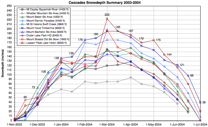
The graph and table below summarize snowdepths at 10 important sites throughout the entire Cascade
Range during the 2003-2004 season. These high-snowdepth sites are all located about 1000 ft below timberline
and are representative of conditions in the subalpine regions on favored slopes (not rain-shadowed areas).
Mount Shasta Ski Bowl was the early season snowdepth leader, then Mount Baker Ski Area pulled ahead in December.
Mount Hood Timberline Lodge took over the lead during the new year, holding on to it until the end of February
when a pair of huge storm systems vaulted Lassen Peak Lake Helen into the top spot, which it has held throughout
most of March, April, and May. The late-May snowfall has boosted Timberline Lodge solidly back into the lead as
of June 1. The maximum snowdepth recorded at any North American measurement site this year was an impressive
222" at Lassen Peak Lake Helen on February 28, 2004, making it the second year in a row that Lassen has
gained that honor (a surprising 245" was recorded there on May 1, 2003, after near-record snowfall of 17 ft
in April 2003). Three measurement sites cracked the 200" mark this season (Lassen Peak, Mount Shasta Old
Ski Bowl, and Mount Hood Timberline Lodge), while Mount Rainier Paradise fell just short with a seasonal maximum
of 192".
Place your mouse over the links below to compare the same plot for the previous season and with
normal values for the period of record (this only works if you have a JavaScript-enabled browser). The
snowdepths peaked much earlier than the typical April 1 this year due to an abnormally warm and dry March, while
last year they peaked as late as May 1 at many locations following unusually large April snowfalls. An archive
of the semimonthly snowdepth stats and commentaries during the current season can be found below the graph.
Mouse-over links to change season graph, click to load season report:
2002-2003 |
2003-2004 |
2004-2005 |
2005-2006 |
Normals
|
|
|
|
---- BRITISH COLUMBIA ---- |
---------- WASHINGTON ---------- |
-------------- OREGON -------------- |
------ CALIFORNIA ------ |
|
|
Mt Cayley
Squamish R.
4400 ft |
|
Whistler Mtn
Ski Area
5400 ft |
|
Mt Baker
Ski Area
4200 ft |
|
Mt Rainier
Paradise
5400 ft |
|
Mt St Helens
Swift Creek
3800 ft |
|
Mt Hood
Timberline
6000 ft |
|
Mt Bachelor
Ski Area
6300 ft |
|
Crater Lake
Park HQ
6400 ft |
|
Mt Shasta
Old Ski Bowl
7600 ft |
|
Lassen Peak
Lake Helen
8200 ft |
| 01 Nov 2003 |
| 0" |
|
| 0" |
|
| 0" |
|
| 0" |
|
| 0" |
|
| 4" |
|
| 0" |
|
| 1" |
|
| 2" |
|
| 0" |
|
| 15 Nov 2003 |
10" | 16" | 20" | 9" | 2" |
9" | 12" | 17" | 45" | 33" |
| 01 Dec 2003 |
48" | 39" | 72" | 59" | 36" |
50" | 36" | 34" | 50" | 39" |
| 15 Dec 2003 |
72" | 57" | 106" | 103" | 69" |
89" | 80" | 72" | 84" | 82" |
| 01 Jan 2004 |
102" | 68" | 129" | 115" | 106" |
136" | 114" | 97" | 133" | 126" |
| 15 Jan 2004 |
94" | 63" | 112" | 111" | 96" |
139" | 106" | 106" | 126" | 124" |
| 01 Feb 2004 |
115" | 85" | 145" | 170" | 112" |
176" | 133" | 119" | 123" | 139" |
| 15 Feb 2004 |
113" | 82" | 140" | 166" | 128" |
180" | 130" | 119" | 126" | 140" |
| 01 Mar 2004 |
120" | 85" | 152" | 176" | 155" |
195" | 145" | 156" | 198" | 222" |
| 15 Mar 2004 |
122" | 85" | 150" | 176" | 142" |
195" | 141" | 129" | 160" | 195" |
| 01 Apr 2004 |
129" | 94" | 159" | 169" | 147" |
182" | 129" | 121" | 146" | 187" |
| 15 Apr 2004 |
111" | 80" | 138" | 147" | 139" |
163" | 111" | 112" | 134" | 170" |
| 01 May 2004 |
95" | 75" | 128" | 135" | 125" |
154" | 94" | 102" | 124" | 175" |
| 15 May 2004 |
76" | 62" | 101" | 118" | 103" |
132" | 70" | 83" | 102" | 144" |
| 01 Jun 2004 |
46" | 37" | 64" | 95" | 74" |
121" | 47" | 57" | 79" | 116" |
| 15 Jun 2004 |
18" | — | 23" | 60" | 41" |
98" | — | 27" | 44" | 80" |
| 01 Jul 2004 |
0" | — | 0" | 8" | 0" |
39" | — | 0" | 0" | 20" |
| |
| Seasonal Max |
145" | 100" | 176" | 192" | 164" |
204" | 159" | 159" | 201" | 222" |
| Date of Max |
27 Mar
2004 | 27 Mar
2004 |
27 Mar
2004 | 07 Mar
2004 | 27 Mar
2004 |
06 Mar
2004 | 06 Mar
2004 | 05 Mar
2004 |
26 Feb
2004 | 28 Feb
2004 |
|
|
Semimonthly Snowfall and Snowdepth Reports for the 2003-2004 Season
|
|
|
The tables below show semimonthly snowfall and snowdepth info at 42 measurement sites along the
entire length of the Cascade Range, primarily on or near the Cascade volcanoes. The frequency of data
collection varies at these sites, from hourly automated telemetry to manual daily or monthly measurements. Note
that multiple sites or data sources are found at several of these locations, and their data values typically
differ slightly from each other. The codes used below for Data Frequency read as follows: H = Hourly Snowdepth
Telemetry, H* = Hourly Snow-Water Telemetry (snowdepth estimated), D = Daily Manual Snowdepth, M = Monthly
Manual Snowdepth (Jan 1 - June 1 or less), A = April 1 Manual Snowdepth Only.
See Information about Cascade Snowdepth Measurement Sites for more
details about these sites including normal snowdepths throughout the season.
The following measurement sites have been added to this list or upgraded for the 2003-2004 season.
The NRCS continues its program of adding
snowdepth gauges to existing SNOTEL sites, and Lassen Volcanic National Park added a snowdepth telemetry site to
the Lake Helen snow course, historically since 1930 the highest-snowdepth site in California (see
press release).
|
State /
Prov. |
Measurement Site Location |
Elevation |
|
Data Source
and Frequency |
|
Information and Notes |
|
| WA |
Rainy Pass
(far NE of Glacier Peak) | 4800 ft |
NRCS |
H | Existing SNOTEL site with snowdepth, added to list |
| Chinook Pass (east of Mt Rainier) |
5600 ft |
NWAC |
H | Existing NWAC telemetry site, added to list |
| Mt Rainier, Sunrise (NE side) |
6400 ft |
NWAC |
H | New NWAC telemetry site for 2003-4, added to list |
| Mt Saint Helens,
June Lake (SE side) | 3300 ft |
NRCS |
H | Snowdepth gauge installed on existing SNOTEL site, added to list |
| OR |
McKenzie
(NW of Three Sisters) | 4800 ft |
NRCS |
H | Snowdepth gauge installed on existing SNOTEL site, added to list |
| Mt McLoughlin,
Billie Creek (SE side) | 5300 ft |
NRCS |
H | Existing SNOTEL site with snowdepth, added to list |
| CA |
Lassen Peak, Lake Helen (south side) | 8200 ft |
CCSS |
H, M | Snowdepth gauge installed near existing manual snow course |
|
|
Snowfall and Snowdepth Info (01 December 2003)
|
|
The 2003-2004 snow year is off to a fine start in the northern part of Cascade Range, following
the torrential rains and destructive flooding of October and early November. Cold air has since dominated the
region, and major storms in the second half of November have brought several feet of new snow to the northern
mountains. Snowdepths are now generally above average from northern Oregon into British Columbia. The Cascades
of southern Oregon and northern California had largely missed out on the bounty, until the last weekend of the
month when a major storm system dumped up to 18 inches of snow, finally boosting snowdepths to well above normal
values in northern California. However, many sites in Oregon remain below average, especially low elevation and
southern sites.
|
|
|
(Italicized numbers are estimated, grayed values are no longer current) |
State /
Prov. |
Measurement Site Location |
Elevation |
|
Data Source
and Frequency |
Date of
Measurement |
|
Snow
Depth |
|
Percent of
Normal |
|
Seasonal
Snowfall |
|
Year to Date
Max. Depth |
| BC |
Tenquille Lake
(east of Mt Meager) | 5500 ft |
BC RFC |
| H, M | 01 Dec 2003 |
28" |
|
70% |
|
— |
|
— |
| Upper Squamish River
(NW of Cayley) | 4400 ft |
BC RFC |
H | 02 Dec 2003 |
48" | 90% | — |
— |
| Callaghan Creek
(east of Mt Cayley) | 3400 ft |
BC RFC |
M | no data |
— | — | — |
— |
| Whistler Mtn, Pig Alley
(N of Garibaldi) |
5400 ft | Ski Area |
D | 01 Dec 2003 |
39" | 93% | 70" |
45", 29 Nov 2003 |
| Orchid Lake
(south of Mt Garibaldi) | 3900 ft |
BC RFC |
M | no data |
— | — | — |
— |
| Grouse Mountain
(North Vancouver) | 3600 ft |
BC RFC |
M | no data |
— | — | — |
— |
| WA |
Mt Baker Ski Area (NE of Mt Baker) |
4200 ft |
NWAC |
H, D | 01 Dec 2003 |
72" | 150% | 164" |
80", 28 Nov 2003 |
| Mt Baker, Wells Creek
(north side) | 4200 ft |
NRCS |
H | 01 Dec 2003 |
35" | 230% | — |
38", 29 Nov 2003 |
| Mt Baker, MF Nooksack
(NW side) | 5000 ft |
NRCS |
H | 01 Dec 2003 |
64" | — | — |
67", 29 Nov 2003 |
| Mt Baker, Elbow Lake
(SW side) | 3200 ft |
NRCS |
H | 01 Dec 2003 |
37" | 230% | — |
40", 29 Nov 2003 |
| Rainy Pass
(far NE of Glacier Peak) | 4800 ft |
NRCS |
H | 01 Dec 2003 |
52" | 160% | — |
62", 28 Nov 2003 |
| Park Creek Ridge
(E of Cascade Pass) | 4600 ft |
NRCS |
H | 01 Dec 2003 |
49" | 140% | — |
59", 28 Nov 2003 |
| Stevens Pass
[see also NRCS site] |
4000 ft |
NWAC |
H, D | 01 Dec 2003 |
41" | 132% | — |
55", 26 Nov 2003 |
| Snoqualmie Pass |
3000 ft |
NWAC |
H, D | 01 Dec 2003 |
30" | 120% | 75" |
39", 28 Nov 2003 |
| Crystal Mtn Ski Area (NE of Rainier) |
4400 ft |
NWAC |
H, D | 01 Dec 2003 |
29" | 121% | — |
38", 26 Nov 2003 |
| Chinook Pass (east of Mt Rainier) |
5600 ft |
NWAC |
H | 01 Dec 2003 |
61" | — | — |
69", 28 Nov 2003 |
| Mt Rainier, Sunrise (NE side) |
6400 ft |
NWAC |
H | 01 Dec 2003 |
34" | — | — |
42", 26 Nov 2003 |
| Mt Rainier, Paradise (south side) |
5400 ft |
NWAC |
H, D | 01 Dec 2003 |
59" | 123% | 131" |
68", 29 Nov 2003 |
| White Pass
[see also NRCS site] |
4500 ft |
NWAC |
H, D | 01 Dec 2003 |
17" | 85% | — |
22", 26 Nov 2003 |
| Pigtail Peak
(N of Goat Rocks) | 5900 ft |
NRCS |
H | 01 Dec 2003 |
42" | 95% | — |
50", 26 Nov 2003 |
| Mt Saint Helens,
Swift Creek (S side) | 3800 ft |
NRCS |
H | 01 Dec 2003 |
36" | — | — |
51", 26 Nov 2003 |
| Mt Saint Helens,
June Lake (SE side) | 3300 ft |
NRCS |
H | 01 Dec 2003 |
25" | 125% | — |
43", 26 Nov 2003 |
| OR |
Mt Hood, Timberline Lodge (S side) |
6000 ft |
NWAC |
H, D | 01 Dec 2003 |
50" | 111% | — |
63", 27 Nov 2003 |
| Mt Hood Test Site
(south side) | 5400 ft |
NRCS |
H | 01 Dec 2003 |
31" | 90% | — |
50", 27 Nov 2003 |
| Mt Hood,
Government Camp (SW side) | 4000 ft |
NCDC |
D | 02 Dec 2003 |
21" | 140% | 60" |
46", 26 Nov 2003 |
| Mt Hood Meadows Ski Area (SE side) |
5200 ft |
NWAC |
H, D | 01 Dec 2003 |
36" | 88% | — |
51", 26 Nov 2003 |
| Hogg Pass
(near Santiam Pass) | 4800 ft |
NRCS |
H | 01 Dec 2003 |
19" | 75% | — |
34", 26 Nov 2003 |
| McKenzie
(NW of Three Sisters) | 4800 ft |
NRCS |
H | 01 Dec 2003 |
28" | 105% | — |
46", 26 Nov 2003 |
| Mt Bachelor Ski Area (north side) |
6300 ft |
Ski Area |
D | 01 Dec 2003 |
36" | 115% | — |
— |
| Cascade Summit
(NE of Diamond Peak) | 4900 ft |
NRCS |
H | 01 Dec 2003 |
19" | 110% | — |
35", 26 Nov 2003 |
| Crater Lake, Park HQ (SW side) |
6400 ft |
NPS |
H, D | 01 Dec 2003 |
34" | 106% | 73" |
— |
| Crater Lake,
Annie Springs (SW side) | 6000 ft |
NRCS |
H | 01 Dec 2003 |
18" | 67% | — |
26", 26 Nov 2003 |
| Fourmile Lake
(east of Mt McLoughlin) | 6000 ft |
NRCS |
H | 01 Dec 2003 |
17" | 100% | — |
24", 26 Nov 2003 |
| Mt McLoughlin,
Billie Creek (SE side) | 5300 ft |
NRCS |
H | 01 Dec 2003 |
13" | 110% | — |
24", 26 Nov 2003 |
| CA |
Medicine Lake (west side of caldera) |
6700 ft |
CCSS |
H*, A | 01 Dec 2003 |
20" | 120% | — |
— |
|
Mt Shasta, Horse Camp (SW side) | 7900 ft |
CCSS |
M | no data |
— | — | — |
— |
| Mt Shasta, Old Ski Bowl (south side) |
7600 ft |
MSAC |
H | 01 Dec 2003 |
50" | 140% | — |
50", 01 Dec 2003 |
| Mt Shasta, Sand Flat (SW side) |
6800 ft |
CCSS |
H, M | 01 Dec 2003 |
40" | 190% | — |
40", 01 Dec 2003 |
|
Mt Shasta, Brewer Creek (east side) | 6200 ft |
CCSS |
M | no data |
— | — | — |
— |
| Lassen Peak, Manzanita Lake (NW side) |
5800 ft |
NPS |
D | 01 Dec 2003 |
0" | 0% | 17" |
6", 16 Nov 2003 |
|
Lassen Peak, Lake Helen (south side) | 8200 ft |
CCSS |
H, M | 01 Dec 2003 |
39" | 95% | — |
39", 01 Dec 2003 |
| Lassen Chalet (SW of Lassen Peak) |
6700 ft |
NPS |
D | 01 Dec 2003 |
38" | 170% | 74" |
38", 01 Dec 2003 |
|
|
Snowfall and Snowdepth Info (15 December 2003)
|
|
The good times continued in December, as a generally cold and wet cycle brought frequent storms
and heavy snowfall, with only occasional rain reaching the higher elevations. This was capped by the major
storm cycle over the weekend of the December 12-14, which brought heavy snowfall to a surprisingly broad range
of latitudes all the way from southern BC to the central Sierra of California. Snowfall amounts during the
weekend ranged from 3-4 ft for much of the Washington and Oregon Cascades, with 2-3 ft in northern California.
Southwestern BC was the poor stepsister for once, receiving only about 1 ft while the rest of the range got
buried. As of December 15, snowdepths are mostly well above average throughout the Cascade Range, even at low
elevation sites which have often had early season difficulties in recent years. Snowdepths generally range from
120-200% of normal from Lassen Peak all the way north to Mount Baker, but then drop below normal heading north
into BC.
|
|
|
(Italicized numbers are estimated, grayed values are no longer current) |
State /
Prov. |
Measurement Site Location |
Elevation |
|
Data Source
and Frequency |
Date of
Measurement |
|
Snow
Depth |
|
Percent of
Normal |
|
Seasonal
Snowfall |
|
Year to Date
Max. Depth |
| BC |
Tenquille Lake
(east of Mt Meager) | 5500 ft |
BC RFC |
| H, M | 15 Dec 2003 |
44" |
|
80% |
|
— |
|
— |
| Upper Squamish River
(NW of Cayley) | 4400 ft |
BC RFC |
H | 15 Dec 2003 |
72" | 90% | — |
— |
| Callaghan Creek
(east of Mt Cayley) | 3400 ft |
BC RFC |
M | no data |
— | — | — |
— |
| Whistler Mtn, Pig Alley
(N of Garibaldi) |
5400 ft | Ski Area |
D | 15 Dec 2003 |
57" | 100% | 124" |
57", 15 Dec 2003 |
| Orchid Lake
(south of Mt Garibaldi) | 3900 ft |
BC RFC |
M | no data |
— | — | — |
— |
| Grouse Mountain
(North Vancouver) | 3600 ft |
BC RFC |
M | no data |
— | — | — |
— |
| WA |
Mt Baker Ski Area (NE of Mt Baker) |
4200 ft |
NWAC |
H, D | 15 Dec 2003 |
106" | 156% | 241" |
110", 14 Dec 2003 |
| Mt Baker, Wells Creek
(north side) | 4200 ft |
NRCS |
H | 15 Dec 2003 |
53" | 180% | — |
53", 15 Dec 2003 |
| Mt Baker, MF Nooksack
(NW side) | 5000 ft |
NRCS |
H | 15 Dec 2003 |
78" | — | — |
78", 15 Dec 2003 |
| Mt Baker, Elbow Lake
(SW side) | 3200 ft |
NRCS |
H | 15 Dec 2003 |
52" | 150% | — |
52", 15 Dec 2003 |
| Rainy Pass
(far NE of Glacier Peak) | 4800 ft |
NRCS |
H | 15 Dec 2003 |
73" | 145% | — |
73", 15 Dec 2003 |
| Park Creek Ridge
(E of Cascade Pass) | 4600 ft |
NRCS |
H | 15 Dec 2003 |
75" | 145% | — |
75", 15 Dec 2003 |
| Stevens Pass
[see also NRCS site] |
4000 ft |
NWAC |
H, D | 15 Dec 2003 |
72" | 164% | 126" |
72", 15 Dec 2003 |
| Snoqualmie Pass |
3000 ft |
NWAC |
H, D | 15 Dec 2003 |
68" | 189% | 152" |
70", 14 Dec 2003 |
| Crystal Mtn Ski Area (NE of Rainier) |
4400 ft |
NWAC |
H, D | 15 Dec 2003 |
51" | 146% | — |
51", 15 Dec 2003 |
| Chinook Pass (east of Mt Rainier) |
5600 ft |
NWAC |
H | 14 Dec 2003 |
104" | — | — |
104", 14 Dec 2003 |
| Mt Rainier, Sunrise (NE side) |
6400 ft |
NWAC |
H | 15 Dec 2003 |
65" | — | — |
67", 14 Dec 2003 |
| Mt Rainier, Paradise (south side) |
5400 ft |
NWAC |
H, D | 15 Dec 2003 |
103" | 151% | 213" |
103", 15 Dec 2003 |
| White Pass
[see also NRCS site] |
4500 ft |
NWAC |
H, D | 15 Dec 2003 |
47" | 157% | — |
47", 15 Dec 2003 |
| Pigtail Peak
(N of Goat Rocks) | 5900 ft |
NRCS |
H | 15 Dec 2003 |
77" | 115% | — |
77", 15 Dec 2003 |
| Mt Saint Helens,
Swift Creek (S side) | 3800 ft |
NRCS |
H | 15 Dec 2003 |
69" | — | — |
69", 15 Dec 2003 |
| Mt Saint Helens,
June Lake (SE side) | 3300 ft |
NRCS |
H | 15 Dec 2003 |
50" | 135% | — |
50", 15 Dec 2003 |
| OR |
Mt Hood, Timberline Lodge (S side) |
6000 ft |
NWAC |
H, D | 15 Dec 2003 |
89" | 137% | — |
89", 15 Dec 2003 |
| Mt Hood Test Site
(south side) | 5400 ft |
NRCS |
H | 15 Dec 2003 |
63" | 120% | — |
63", 15 Dec 2003 |
| Mt Hood,
Government Camp (SW side) | 4000 ft |
NCDC |
D | 15 Dec 2003 |
36" | 165% | 86" |
46", 26 Nov 2003 |
| Mt Hood Meadows Ski Area (SE side) |
5200 ft |
NWAC |
H, D | 15 Dec 2003 |
61" | 107% | — |
61", 15 Dec 2003 |
| Hogg Pass
(near Santiam Pass) | 4800 ft |
NRCS |
H | 15 Dec 2003 |
45" | 120% | — |
47", 14 Dec 2003 |
| McKenzie
(NW of Three Sisters) | 4800 ft |
NRCS |
H | 15 Dec 2003 |
56" | 145% | — |
56", 15 Dec 2003 |
| Mt Bachelor Ski Area (north side) |
6300 ft |
Ski Area |
D | 15 Dec 2003 |
80" | 170% | — |
80", 15 Dec 2003 |
| Cascade Summit
(NE of Diamond Peak) | 4900 ft |
NRCS |
H | 15 Dec 2003 |
45" | 150% | — |
46", 14 Dec 2003 |
| Crater Lake, Park HQ (SW side) |
6400 ft |
NPS |
H, D | 15 Dec 2003 |
72" | 150% | 138" |
72", 15 Dec 2003 |
| Crater Lake,
Annie Springs (SW side) | 6000 ft |
NRCS |
H | 15 Dec 2003 |
51" | 125% | — |
52", 14 Dec 2003 |
| Fourmile Lake
(east of Mt McLoughlin) | 6000 ft |
NRCS |
H | 15 Dec 2003 |
46" | 160% | — |
47", 14 Dec 2003 |
| Mt McLoughlin,
Billie Creek (SE side) | 5300 ft |
NRCS |
H | 15 Dec 2003 |
48" | 220% | — |
49", 14 Dec 2003 |
| CA |
Medicine Lake (west side of caldera) |
6700 ft |
CCSS |
H*, A | 15 Dec 2003 |
43" | 170% | — |
45", 14 Dec 2003 |
|
Mt Shasta, Horse Camp (SW side) | 7900 ft |
CCSS |
M | no data |
— | — | — |
— |
| Mt Shasta, Old Ski Bowl (south side) |
7600 ft |
MSAC |
H | 15 Dec 2003 |
84" | 160% | — |
88", 14 Dec 2003 |
| Mt Shasta, Sand Flat (SW side) |
6800 ft |
CCSS |
H, M | 15 Dec 2003 |
59" | 150% | — |
61", 14 Dec 2003 |
|
Mt Shasta, Brewer Creek (east side) | 6200 ft |
CCSS |
M | no data |
— | — | — |
— |
| Lassen Peak, Manzanita Lake (NW side) |
5800 ft |
NPS |
D | 15 Dec 2003 |
18" | 180% | 46" |
18", 15 Dec 2003 |
|
Lassen Peak, Lake Helen (south side) | 8200 ft |
CCSS |
H, M | 15 Dec 2003 |
82" | 135% | — |
85", 14 Dec 2003 |
| Lassen Chalet (SW of Lassen Peak) |
6700 ft |
NPS |
D | 15 Dec 2003 |
68" | 170% | 131" |
74", 14 Dec 2003 |
|
|
Snowfall and Snowdepth Info (01 January 2004)
|
|
The excellent cold and wet weather pattern continued in the latter half of December, beginning
with a system that hit northern WA and southwestern BC with 2-3 ft of snow on Dec 16-17. Santa brought the next
major dump with him on Dec 24-25, depositing 2-4 ft of snowfall over the entire length of the Cascade range,
followed by yet another system on Dec 28-29 which again left 2-4 ft from California to northern Washington, with
lesser amounts in BC. Finally, 2003 was capped off and the New Year was ushered in by (guess what) another
major system, dropping 2-3 more feet of snow from California to southern Washington. These last systems
featured very low snow levels, right down to sea level at times in Washington and Oregon and shockingly dropping
nearly a foot of snow in Redding, CA, well below 1000 ft elevation.
As of January 1, snowdepths remain well above average throughout most of the Cascade Range, even at low
elevation sites which have often had early season difficulties in recent years. Snowdepths generally range from
120-200% of normal from Lassen Peak all the way north to southernmost BC, but then drop closer to normal heading
farther north into BC. In the region near the Oregon-California border, from Mount Shasta to Mount McLoughlin,
snowdepths exceed 200% of normal for this date and are in fact greater than the normal April 1 annual maxima at
these sites.
|
|
|
(Italicized numbers are estimated, grayed values are no longer current) |
State /
Prov. |
Measurement Site Location |
Elevation |
|
Data Source
and Frequency |
Date of
Measurement |
|
Snow
Depth |
|
Percent of
Normal |
|
Seasonal
Snowfall |
|
Year to Date
Max. Depth |
| BC |
Tenquille Lake
(east of Mt Meager) | 5500 ft |
BC RFC |
| H, M | 28 Dec 2003 |
67" |
|
100% |
|
— |
|
— |
| Upper Squamish River
(NW of Cayley) | 4400 ft |
BC RFC |
H | 01 Jan 2004 |
102" | 105% | — |
109", 28 Dec 2003 |
| Callaghan Creek
(east of Mt Cayley) | 3400 ft |
BC RFC |
M | no data |
— | — | — |
— |
| Whistler Mtn, Pig Alley
(N of Garibaldi) |
5400 ft | Ski Area |
D | 01 Jan 2004 |
68" | 108% | 189" |
74", 26 Dec 2003 |
| Orchid Lake
(south of Mt Garibaldi) | 3900 ft |
BC RFC |
M | 29 Dec 2003 |
109" | 135% | — |
— |
| Grouse Mountain
(North Vancouver) | 3600 ft |
BC RFC |
M | 31 Dec 2003 |
89" | 169% | — |
— |
| WA |
Mt Baker Ski Area (NE of Mt Baker) |
4200 ft |
NWAC |
H, D | 01 Jan 2004 |
129" | 141% | 326" |
134", 28 Dec 2003 |
| Mt Baker, Wells Creek
(north side) | 4200 ft |
NRCS |
H | 01 Jan 2004 |
70" | 175% | — |
77", 29 Dec 2003 |
| Mt Baker, MF Nooksack
(NW side) | 5000 ft |
NRCS |
H | 01 Jan 2004 |
101" | — | — |
105", 28 Dec 2003 |
| Mt Baker, Elbow Lake
(SW side) | 3200 ft |
NRCS |
H | 01 Jan 2004 |
69" | 150% | — |
72", 29 Dec 2003 |
| Rainy Pass
(far NE of Glacier Peak) | 4800 ft |
NRCS |
H | 01 Jan 2004 |
66" | 100% | — |
76", 17 Dec 2003 |
| Park Creek Ridge
(E of Cascade Pass) | 4600 ft |
NRCS |
H | 01 Jan 2004 |
85" | 123% | — |
86", 28 Dec 2003 |
| Stevens Pass
[see also NRCS site] |
4000 ft |
NWAC |
H, D | 01 Jan 2004 |
68" | 110% | 181" |
74", 28 Dec 2003 |
| Snoqualmie Pass |
3000 ft |
NWAC |
H, D | 01 Jan 2004 |
66" | 127% | 197" |
70", 31 Dec 2003 |
| Crystal Mtn Ski Area (NE of Rainier) |
4400 ft |
NWAC |
H, D | 01 Jan 2004 |
59" | 148% | — |
61", 28 Dec 2003 |
| Chinook Pass (east of Mt Rainier) |
5600 ft |
NWAC |
H | 30 Dec 2003 |
116" | — | — |
120", 29 Dec 2003 |
| Mt Rainier, Sunrise (NE side) |
6400 ft |
NWAC |
H | 30 Dec 2003 |
76" | — | — |
81", 28 Dec 2003 |
| Mt Rainier, Paradise (south side) |
5400 ft |
NWAC |
H, D | 01 Jan 2004 |
115" | 126% | 305" |
115", 01 Jan 2004 |
| White Pass
[see also NRCS site] |
4500 ft |
NWAC |
H, D | 01 Jan 2004 |
52" | 149% | — |
52", 01 Jan 2004 |
| Pigtail Peak
(N of Goat Rocks) | 5900 ft |
NRCS |
H | 01 Jan 2004 |
92" | 105% | — |
95", 29 Dec 2003 |
| Mt Saint Helens,
Swift Creek (S side) | 3800 ft |
NRCS |
H | 01 Jan 2004 |
106" | — | — |
106", 01 Jan 2004 |
| Mt Saint Helens,
June Lake (SE side) | 3300 ft |
NRCS |
H | 01 Jan 2004 |
72" | 145% | — |
72", 01 Jan 2004 |
| OR |
Mt Hood, Timberline Lodge (S side) |
6000 ft |
NWAC |
H, D | 01 Jan 2004 |
136" | 179% | — |
136", 01 Jan 2004 |
| Mt Hood Test Site
(south side) | 5400 ft |
NRCS |
H | 01 Jan 2004 |
102" | 144% | — |
105", 29 Dec 2003 |
| Mt Hood,
Government Camp (SW side) | 4000 ft |
NCDC |
D | 01 Jan 2004 |
59" | 190% | 129" |
61", 31 Dec 2003 |
| Mt Hood Meadows Ski Area (SE side) |
5200 ft |
NWAC |
H, D | 01 Jan 2004 |
91" | 126% | — |
97", 29 Dec 2003 |
| Hogg Pass
(near Santiam Pass) | 4800 ft |
NRCS |
H | 01 Jan 2004 |
81" | 162% | — |
81", 01 Jan 2004 |
| McKenzie
(NW of Three Sisters) | 4800 ft |
NRCS |
H | 01 Jan 2004 |
98" | 188% | — |
98", 01 Jan 2004 |
| Mt Bachelor Ski Area (north side) |
6300 ft |
Ski Area |
D | 01 Jan 2004 |
114" | 180% | — |
114", 01 Jan 2004 |
| Cascade Summit
(NE of Diamond Peak) | 4900 ft |
NRCS |
H | 01 Jan 2004 |
74" | 172% | — |
74", 01 Jan 2004 |
| Crater Lake, Park HQ (SW side) |
6400 ft |
NPS |
H, D | 01 Jan 2004 |
97" | 150% | 202" |
97", 01 Jan 2004 |
| Crater Lake,
Annie Springs (SW side) | 6000 ft |
NRCS |
H | 01 Jan 2004 |
76" | 140% | — |
76", 01 Jan 2004 |
| Fourmile Lake
(east of Mt McLoughlin) | 6000 ft |
NRCS |
H | 01 Jan 2004 |
73" | 175% | — |
73", 01 Jan 2004 |
| Mt McLoughlin,
Billie Creek (SE side) | 5300 ft |
NRCS |
H | 01 Jan 2004 |
68" | 220% | — |
68", 01 Jan 2004 |
| CA |
Medicine Lake (west side of caldera) |
6700 ft |
CCSS |
H*, A | 01 Jan 2004 |
82" | 250% | — |
82", 01 Jan 2004 |
|
Mt Shasta, Horse Camp (SW side) | 7900 ft |
CCSS |
M | no data |
— | — | — |
— |
| Mt Shasta, Old Ski Bowl (south side) |
7600 ft |
MSAC |
H | 01 Jan 2004 |
133" | 190% | 185" |
133", 01 Jan 2004 |
| Mt Shasta, Sand Flat (SW side) |
6800 ft |
CCSS |
H, M | 01 Jan 2004 |
101" | 180% | — |
101", 01 Jan 2004 |
|
Mt Shasta, Brewer Creek (east side) | 6200 ft |
CCSS |
M | no data |
— | — | — |
— |
| Lassen Peak, Manzanita Lake (NW side) |
5800 ft |
NPS |
D | 01 Jan 2004 |
36" | 240% | 83" |
36", 01 Jan 2004 |
|
Lassen Peak, Lake Helen (south side) | 8200 ft |
CCSS |
H, M | 01 Jan 2004 |
126" | 154% | — |
126", 01 Jan 2004 |
| Lassen Chalet (SW of Lassen Peak) |
6700 ft |
NPS |
D | 01 Jan 2004 |
118" | 200% | 223" |
118", 01 Jan 2004 |
|
|
Snowfall and Snowdepth Info (15 January 2004)
|
|
The New Year was ushered in by more heavy snowfall and the coldest temperatures in nearly a
decade, with lows dropping below 0 °F at the Washington Cascade passes and even below -20 °F
in the high country of southwestern BC during the first weekend of 2004. The heaviest snowfalls over the first
week of 2004 were concentrated in the region from Mount Rainier south to Crater Lake, where many sites received
4-7 ft of snowfall, with lesser amounts to the north and south. Heavy snowfall of a foot or more fell even in
the lowlands of WA and OR, while Timberline Lodge on Mount Hood reinforced its position as this season's
snowdepth leader, reaching nearly 14 ft of base by January 7. But then the weather pattern shifted completely
the following week, with warming temperatures and rising freezing levels. As expected, this brought substantial
settlement and a significant decrease in snowdepths, capped on January 14 by the first major rains to reach
higher elevations up to 6000-7000 ft in over a month.
Despite the recent decrease, snowdepths remain above average throughout most of the Cascade Range as of January
15, even at low elevation sites which have often had early season difficulties in recent years. Snowdepths
generally range from 110-160% of normal from Lassen Peak all the way north to the central WA Cascades, but then
drop to normal or below heading into northern WA and BC. In the region near the Oregon-California border, from
Mount Shasta to Mount McLoughlin, snowdepths exceed 150% of normal for this date and are close to or greater
than the normal April 1 annual maxima at these sites.
|
|
|
(Italicized numbers are estimated, grayed values are no longer current) |
State /
Prov. |
Measurement Site Location |
Elevation |
|
Data Source
and Frequency |
Date of
Measurement |
|
Snow
Depth |
|
Percent of
Normal |
|
Seasonal
Snowfall |
|
Year to Date
Max. Depth |
| BC |
Tenquille Lake
(east of Mt Meager) | 5500 ft |
BC RFC |
| H, M | 15 Jan 2004 |
65" |
|
83% |
|
— |
|
— |
| Upper Squamish River
(NW of Cayley) | 4400 ft |
BC RFC |
H | 15 Jan 2004 |
94" | 92% | — |
117", 09 Jan 2004 |
| Callaghan Creek
(east of Mt Cayley) | 3400 ft |
BC RFC |
M | no data |
— | — | — |
— |
| Whistler Mtn, Pig Alley
(N of Garibaldi) |
5400 ft | Ski Area |
D | 15 Jan 2004 |
63" | 88% | 220" |
74", 26 Dec 2003 |
| Orchid Lake
(south of Mt Garibaldi) | 3900 ft |
BC RFC |
M | 29 Dec 2003 |
109" | 135% | — |
— |
| Grouse Mountain
(North Vancouver) | 3600 ft |
BC RFC |
M | 31 Dec 2003 |
89" | 169% | — |
— |
| WA |
Mt Baker Ski Area (NE of Mt Baker) |
4200 ft |
NWAC |
H, D | 15 Jan 2004 |
112" | 104% | 370" |
142", 08 Jan 2004 |
| Mt Baker, Wells Creek
(north side) | 4200 ft |
NRCS |
H | 15 Jan 2004 |
59" | 130% | — |
77", 29 Dec 2003 |
| Mt Baker, MF Nooksack
(NW side) | 5000 ft |
NRCS |
H | 15 Jan 2004 |
87" | — | — |
110", 03 Jan 2004 |
| Mt Baker, Elbow Lake
(SW side) | 3200 ft |
NRCS |
H | 15 Jan 2004 |
54" | 100% | — |
76", 04 Jan 2004 |
| Rainy Pass
(far NE of Glacier Peak) | 4800 ft |
NRCS |
H | 15 Jan 2004 |
66" | 85% | — |
76", 17 Dec 2003 |
| Park Creek Ridge
(E of Cascade Pass) | 4600 ft |
NRCS |
H | 15 Jan 2004 |
79" | 90% | — |
90", 08 Jan 2004 |
| Stevens Pass
[see also NRCS site] |
4000 ft |
NWAC |
H, D | 15 Jan 2004 |
65" | 89% | 222" |
78", 07 Jan 2004 |
| Snoqualmie Pass |
3000 ft |
NWAC |
H, D | 15 Jan 2004 |
70" | 108% | 247" |
87", 08 Jan 2004 |
| Crystal Mtn Ski Area (NE of Rainier) |
4400 ft |
NWAC |
H, D | 15 Jan 2004 |
54" | 112% | — |
66", 08 Jan 2004 |
| Chinook Pass (east of Mt Rainier) |
5600 ft |
NWAC |
H | 30 Dec 2003 |
116" | — | — |
— |
| Mt Rainier, Sunrise (NE side) |
6400 ft |
NWAC |
H | 30 Dec 2003 |
76" | — | — |
— |
| Mt Rainier, Paradise (south side) |
5400 ft |
NWAC |
H, D | 15 Jan 2004 |
111" | 99% | 378" |
145", 07 Jan 2004 |
| White Pass
[see also NRCS site] |
4500 ft |
NWAC |
H, D | 15 Jan 2004 |
54" | 123% | — |
66", 07 Jan 2004 |
| Pigtail Peak
(N of Goat Rocks) | 5900 ft |
NRCS |
H | 15 Jan 2004 |
87" | 80% | — |
105", 07 Jan 2004 |
| Mt Saint Helens,
Swift Creek (S side) | 3800 ft |
NRCS |
H | 15 Jan 2004 |
96" | — | — |
124", 07 Jan 2004 |
| Mt Saint Helens,
June Lake (SE side) | 3300 ft |
NRCS |
H | 15 Jan 2004 |
67" | 120% | — |
94", 07 Jan 2004 |
| OR |
Mt Hood, Timberline Lodge (S side) |
6000 ft |
NWAC |
H, D | 15 Jan 2004 |
139" | 138% | — |
164", 07 Jan 2004 |
| Mt Hood Test Site
(south side) | 5400 ft |
NRCS |
H | 15 Jan 2004 |
100" | 115% | — |
122", 07 Jan 2004 |
| Mt Hood,
Government Camp (SW side) | 4000 ft |
NCDC |
D | 15 Jan 2004 |
45" | 115% | 160" |
77", 07 Jan 2004 |
| Mt Hood Meadows Ski Area (SE side) |
5200 ft |
NWAC |
H, D | 15 Jan 2004 |
100" | 115% | — |
120", 07 Jan 2004 |
| Hogg Pass
(near Santiam Pass) | 4800 ft |
NRCS |
H | 15 Jan 2004 |
68" | 110% | — |
88", 04 Jan 2004 |
| McKenzie
(NW of Three Sisters) | 4800 ft |
NRCS |
H | 15 Jan 2004 |
78" | 125% | — |
107", 04 Jan 2004 |
| Mt Bachelor Ski Area (north side) |
6300 ft |
Ski Area |
D | 15 Jan 2004 |
106" | 140% | — |
124", 08 Jan 2004 |
| Cascade Summit
(NE of Diamond Peak) | 4900 ft |
NRCS |
H | 15 Jan 2004 |
64" | 125% | — |
85", 04 Jan 2004 |
| Crater Lake, Park HQ (SW side) |
6400 ft |
NPS |
H, D | 15 Jan 2004 |
106" | 134% | 277" |
120", 08 Jan 2004 |
| Crater Lake,
Annie Springs (SW side) | 6000 ft |
NRCS |
H | 15 Jan 2004 |
87" | 130% | — |
104", 08 Jan 2004 |
| Fourmile Lake
(east of Mt McLoughlin) | 6000 ft |
NRCS |
H | 15 Jan 2004 |
67" | 145% | — |
79", 02 Jan 2004 |
| Mt McLoughlin,
Billie Creek (SE side) | 5300 ft |
NRCS |
H | 15 Jan 2004 |
62" | 165% | — |
74", 04 Jan 2004 |
| CA |
Medicine Lake (west side of caldera) |
6700 ft |
CCSS |
H*, A | 15 Jan 2004 |
74" | 185% | — |
82", 01 Jan 2004 |
|
Mt Shasta, Horse Camp (SW side) | 7900 ft |
CCSS |
M | no data |
— | — | — |
— |
| Mt Shasta, Old Ski Bowl (south side) |
7600 ft |
MSAC |
H | 15 Jan 2004 |
126" | 160% | 221" |
138", 09 Jan 2004 |
| Mt Shasta, Sand Flat (SW side) |
6800 ft |
CCSS |
H, M | 15 Jan 2004 |
91" | 140% | — |
102", 02 Jan 2004 |
|
Mt Shasta, Brewer Creek (east side) | 6200 ft |
CCSS |
M | no data |
— | — | — |
— |
| Lassen Peak, Manzanita Lake (NW side) |
5800 ft |
NPS |
D | 15 Jan 2004 |
27" | 150% | 100" |
41", 02 Jan 2004 |
|
Lassen Peak, Lake Helen (south side) | 8200 ft |
CCSS |
H, M | 15 Jan 2004 |
124" | 120% | — |
133", 02 Jan 2004 |
| Lassen Chalet (SW of Lassen Peak) |
6700 ft |
NPS |
D | 15 Jan 2004 |
103" | 137% | 257" |
118", 02 Jan 2004 |
|
|
Snowfall and Snowdepth Info (01 February 2004)
|
|
Following a predominantly dry week, winter finally returned in the last week of January, with a
major storm cycle dropping 3-4 ft of snow from northern WA to southern OR, with somewhat lesser amounts in BC
and much less in CA. Unfortunately, a huge wedge of warm tropical air was pulled into OR and WA as the system
intensified at the peak of this storm cycle, bringing massive amounts of rain (up to 4-6 inches) at elevations
as high as 6000-7000 ft, while BC and even CA miraculously escaped the heavy rain. Thankfully, the rain was
again followed by heavy snowfall over the final 2 days of the month, topping things off with 1-3 ft of fresh
light powder at low snow levels from southern OR to BC.
As of February 1, snowdepths remain above average throughout most of the Cascade Range, even at low elevation
sites which have often had difficulties in recent years. Snowdepths generally range from 110-150% of normal
from Lassen Peak all the way to southernmost BC, but then drop to near normal or below heading farther north.
Mount Rainier (Paradise) and Mount Hood (Timberline Lodge) are now vying for superiority as this season's
snowdepth leader, with both reaching depths of over 14 ft and already matching or slightly exceeding their
typical April 1 annual maxima. In a small region near Mount McLoughlin in southern Oregon (which is
historically the lowest snowfall region in the main Cascade Range), snowdepths exceed 160% of normal for this
date and far surpass the normal annual maxima at these sites.
|
|
|
(Italicized numbers are estimated, grayed values are no longer current) |
State /
Prov. |
Measurement Site Location |
Elevation |
|
Data Source
and Frequency |
Date of
Measurement |
|
Snow
Depth |
|
Percent of
Normal |
|
Seasonal
Snowfall |
|
Year to Date
Max. Depth |
| BC |
Tenquille Lake
(east of Mt Meager) | 5500 ft |
BC RFC |
| H, M | 01 Feb 2004 |
80" |
|
88% |
|
— |
|
— |
| Upper Squamish River
(NW of Cayley) | 4400 ft |
BC RFC |
H | 01 Feb 2004 |
115" | 96% | — |
121", 30 Jan 2004 |
| Callaghan Creek
(east of Mt Cayley) | 3400 ft |
BC RFC |
M | 29 Jan 2004 |
62" | 105% | — |
— |
| Whistler Mtn, Pig Alley
(N of Garibaldi) |
5400 ft | Ski Area |
D | 01 Feb 2004 |
85" | 105% | 267" |
92", 30 Jan 2004 |
| Orchid Lake
(south of Mt Garibaldi) | 3900 ft |
BC RFC |
M | 05 Feb 2004 |
125" | 116% | — |
— |
| Grouse Mountain
(North Vancouver) | 3600 ft |
BC RFC |
M | 27 Jan 2004 |
93" | 115% | — |
— |
| WA |
Mt Baker Ski Area (NE of Mt Baker) |
4200 ft |
NWAC |
H, D | 01 Feb 2004 |
145" | 117% | 452" |
145", 01 Feb 2004 |
| Mt Baker, Wells Creek
(north side) | 4200 ft |
NRCS |
H | 01 Feb 2004 |
77" | 140% | — |
77", 01 Feb 2004 |
| Mt Baker, MF Nooksack
(NW side) | 5000 ft |
NRCS |
H | 01 Feb 2004 |
124" | — | — |
124", 01 Feb 2004 |
| Mt Baker, Elbow Lake
(SW side) | 3200 ft |
NRCS |
H | 27 Jan 2004 |
74" | 110% | — |
76", 04 Jan 2004 |
| Rainy Pass
(far NE of Glacier Peak) | 4800 ft |
NRCS |
H | 01 Feb 2004 |
84" | 95% | — |
86", 31 Jan 2004 |
| Park Creek Ridge
(E of Cascade Pass) | 4600 ft |
NRCS |
H | 01 Feb 2004 |
91" | 85% | — |
92", 31 Jan 2004 |
| Stevens Pass
[see also NRCS site] |
4000 ft |
NWAC |
H, D | 01 Feb 2004 |
96" | 110% | 285" |
96", 01 Feb 2004 |
| Snoqualmie Pass |
3000 ft |
NWAC |
H, D | 01 Feb 2004 |
85" | 108% | 299" |
88", 27 Jan 2004 |
| Crystal Mtn Ski Area (NE of Rainier) |
4400 ft |
NWAC |
H, D | 01 Feb 2004 |
78" | 134% | — |
78", 01 Feb 2004 |
| Chinook Pass (east of Mt Rainier) |
5600 ft |
NWAC |
H | 30 Dec 2003 |
116" | — | — |
— |
| Mt Rainier, Sunrise (NE side) |
6400 ft |
NWAC |
H | 30 Dec 2003 |
76" | — | — |
— |
| Mt Rainier, Paradise (south side) |
5400 ft |
NWAC |
H, D | 01 Feb 2004 |
170" | 129% | 477" |
170", 01 Feb 2004 |
| White Pass
[see also NRCS site] |
4500 ft |
NWAC |
H, D | 01 Feb 2004 |
80" | 154% | — |
80", 01 Feb 2004 |
| Pigtail Peak
(N of Goat Rocks) | 5900 ft |
NRCS |
H | 01 Feb 2004 |
132" | 100% | — |
132", 01 Feb 2004 |
| Mt Saint Helens,
Swift Creek (S side) | 3800 ft |
NRCS |
H | 01 Feb 2004 |
112" | — | — |
124", 07 Jan 2004 |
| Mt Saint Helens,
June Lake (SE side) | 3300 ft |
NRCS |
H | 01 Feb 2004 |
83" | 115% | — |
94", 07 Jan 2004 |
| OR |
Mt Hood, Timberline Lodge (S side) |
6000 ft |
NWAC |
H, D | 01 Feb 2004 |
176" | 150% | — |
176", 01 Feb 2004 |
| Mt Hood Test Site
(south side) | 5400 ft |
NRCS |
H | 01 Feb 2004 |
124" | 123% | — |
124", 01 Feb 2004 |
| Mt Hood,
Government Camp (SW side) | 4000 ft |
NCDC |
D | 01 Feb 2004 |
47" | 105% | 186" |
77", 07 Jan 2004 |
| Mt Hood Meadows Ski Area (SE side) |
5200 ft |
NWAC |
H, D | 01 Feb 2004 |
121" | 121% | — |
123", 31 Jan 2004 |
| Hogg Pass
(near Santiam Pass) | 4800 ft |
NRCS |
H | 01 Feb 2004 |
81" | 107% | — |
88", 04 Jan 2004 |
| McKenzie
(NW of Three Sisters) | 4800 ft |
NRCS |
H | 01 Feb 2004 |
98" | 134% | — |
107", 04 Jan 2004 |
| Mt Bachelor Ski Area (north side) |
6300 ft |
Ski Area |
D | 01 Feb 2004 |
133" | 150% | — |
133", 01 Feb 2004 |
| Cascade Summit
(NE of Diamond Peak) | 4900 ft |
NRCS |
H | 01 Feb 2004 |
84" | 140% | — |
85", 31 Jan 2004 |
| Crater Lake, Park HQ (SW side) |
6400 ft |
NPS |
H, D | 01 Feb 2004 |
119" | 125% | 330" |
120", 08 Jan 2004 |
| Crater Lake,
Annie Springs (SW side) | 6000 ft |
NRCS |
H | 01 Feb 2004 |
95" | 117% | — |
104", 08 Jan 2004 |
| Fourmile Lake
(east of Mt McLoughlin) | 6000 ft |
NRCS |
H | 01 Feb 2004 |
78" | 156% | — |
80", 30 Jan 2004 |
| Mt McLoughlin,
Billie Creek (SE side) | 5300 ft |
NRCS |
H | 01 Feb 2004 |
76" | 169% | — |
77", 30 Jan 2004 |
| CA |
Medicine Lake (west side of caldera) |
6700 ft |
CCSS |
H*, A | 01 Feb 2004 |
72" | 150% | — |
82", 01 Jan 2004 |
|
Mt Shasta, Horse Camp (SW side) | 7900 ft |
CCSS |
M | 29 Jan 2004 |
113" | 128% | — |
— |
| Mt Shasta, Old Ski Bowl (south side) |
7600 ft |
MSAC |
H | 31 Jan 2004 |
123" | 140% | 235" |
138", 09 Jan 2004 |
| Mt Shasta, Sand Flat (SW side) |
6800 ft |
CCSS |
H, M | 01 Feb 2004 |
88" | 121% | — |
102", 02 Jan 2004 |
|
Mt Shasta, Brewer Creek (east side) | 6200 ft |
CCSS |
M | no data |
— | — | — |
— |
| Lassen Peak, Manzanita Lake (NW side) |
5800 ft |
NPS |
D | 01 Feb 2004 |
33" | 150% | 115" |
41", 02 Jan 2004 |
|
Lassen Peak, Lake Helen (south side) | 8200 ft |
CCSS |
H, M | 29 Jan 2004 |
139" | 114% | — |
139", 29 Jan 2004 |
| Lassen Chalet (SW of Lassen Peak) |
6700 ft |
NPS |
D | 01 Feb 2004 |
108" | 125% | 281" |
118", 02 Jan 2004 |
|
|
Snowfall and Snowdepth Info (15 February 2004)
|
|
The first week of February produced a pair of modest storm systems, leaving a total of 1-2 ft of
snowfall and maintaining snowdepths at or near seasonal highs throughout most of the Cascade Range. But the
second week brought the largest high-pressure ridge of the winter thus far, providing an entire week of stable,
clear and dry weather from California all the way to southern BC, and causing significant settlement and
consolidation of the snowpack. This was followed by a return to a stormy weather pattern at the start of
the third week of the month, with a weak system dropping a few inches to a foot of snowfall over the
weekend and much larger wetter systems expected to follow.
As of February 15, snowdepths remain above average throughout most of the Cascade Range, even at
low elevation sites which have often had difficulties in recent years. Snowdepths generally range from 100-140%
of normal from Lassen Peak all the way to northern WA, but then drop below normal heading farther
north into BC. Mount Rainier (Paradise) and Mount Hood (Timberline Lodge) continue to battle for this
season's snowdepth lead, with both maintaining depths of 14-15 ft and already matching or slightly exceeding
their typical April 1 annual maxima. In a small region near Mount McLoughlin in southern Oregon (which is
historically the lowest snowfall region in the main Cascade Range), snowdepths exceed 150% of normal for this
date and far surpass the normal annual maxima at these sites.
|
|
|
(Italicized numbers are estimated, grayed values are no longer current) |
State /
Prov. |
Measurement Site Location |
Elevation |
|
Data Source
and Frequency |
Date of
Measurement |
|
Snow
Depth |
|
Percent of
Normal |
|
Seasonal
Snowfall |
|
Year to Date
Max. Depth |
| BC |
Tenquille Lake
(east of Mt Meager) | 5500 ft |
BC RFC |
| H, M | 15 Feb 2004 |
80" |
|
80% |
|
— |
|
— |
| Upper Squamish River
(NW of Cayley) | 4400 ft |
BC RFC |
H | 15 Feb 2004 |
113" | 90% | — |
126", 06 Feb 2004 |
| Callaghan Creek
(east of Mt Cayley) | 3400 ft |
BC RFC |
M | 29 Jan 2004 |
62" | 105% | — |
— |
| Whistler Mtn, Pig Alley
(N of Garibaldi) |
5400 ft | Ski Area |
D | 15 Feb 2004 |
82" | 91% | 287" |
92", 30 Jan 2004 |
| Orchid Lake
(south of Mt Garibaldi) | 3900 ft |
BC RFC |
M | 05 Feb 2004 |
125" | 116% | — |
— |
| Grouse Mountain
(North Vancouver) | 3600 ft |
BC RFC |
M | 27 Jan 2004 |
93" | 115% | — |
— |
| WA |
Mt Baker Ski Area (NE of Mt Baker) |
4200 ft |
NWAC |
H, D | 15 Feb 2004 |
140" | 101% | 482" |
146", 07 Feb 2004 |
| Mt Baker, Wells Creek
(north side) | 4200 ft |
NRCS |
H | 15 Feb 2004 |
71" | 120% | — |
77", 01 Feb 2004 |
| Mt Baker, MF Nooksack
(NW side) | 5000 ft |
NRCS |
H | 15 Feb 2004 |
121" | — | — |
125", 04 Feb 2004 |
| Mt Baker, Elbow Lake
(SW side) | 3200 ft |
NRCS |
H | 15 Feb 2004 |
75" | 100% | — |
79", 05 Feb 2004 |
| Rainy Pass
(far NE of Glacier Peak) | 4800 ft |
NRCS |
H | 15 Feb 2004 |
75" | 80% | — |
86", 31 Jan 2004 |
| Park Creek Ridge
(E of Cascade Pass) | 4600 ft |
NRCS |
H | 15 Feb 2004 |
86" | 75% | — |
92", 31 Jan 2004 |
| Stevens Pass
[see also NRCS site] |
4000 ft |
NWAC |
H, D | 15 Feb 2004 |
86" | 91% | 300" |
96", 01 Feb 2004 |
| Snoqualmie Pass |
3000 ft |
NWAC |
H, D | 15 Feb 2004 |
85" | 98% | 322" |
90", 07 Feb 2004 |
| Crystal Mtn Ski Area (NE of Rainier) |
4400 ft |
NWAC |
H, D | 15 Feb 2004 |
73" | 122% | — |
78", 01 Feb 2004 |
| Chinook Pass (east of Mt Rainier) |
5600 ft |
NWAC |
H | 30 Dec 2003 |
116" | — | — |
— |
| Mt Rainier, Sunrise (NE side) |
6400 ft |
NWAC |
H | 30 Dec 2003 |
76" | — | — |
— |
| Mt Rainier, Paradise (south side) |
5400 ft |
NWAC |
H, D | 15 Feb 2004 |
166" | 115% | 496" |
170", 01 Feb 2004 |
| White Pass
[see also NRCS site] |
4500 ft |
NWAC |
H, D | 15 Feb 2004 |
67" | 122% | — |
80", 01 Feb 2004 |
| Pigtail Peak
(N of Goat Rocks) | 5900 ft |
NRCS |
H | 15 Feb 2004 |
118" | 85% | — |
132", 01 Feb 2004 |
| Mt Saint Helens,
Swift Creek (S side) | 3800 ft |
NRCS |
H | 15 Feb 2004 |
128" | — | — |
128", 15 Feb 2004 |
| Mt Saint Helens,
June Lake (SE side) | 3300 ft |
NRCS |
H | 15 Feb 2004 |
87" | 115% | — |
94", 07 Jan 2004 |
| OR |
Mt Hood, Timberline Lodge (S side) |
6000 ft |
NWAC |
H, D | 15 Feb 2004 |
180" | 140% | — |
184", 07 Feb 2004 |
| Mt Hood Test Site
(south side) | 5400 ft |
NRCS |
H | 15 Feb 2004 |
128" | 115% | — |
132", 07 Feb 2004 |
| Mt Hood,
Government Camp (SW side) | 4000 ft |
NCDC |
D | 15 Feb 2004 |
48" | 110% | 200" |
77", 07 Jan 2004 |
| Mt Hood Meadows Ski Area (SE side) |
5200 ft |
NWAC |
H, D | 15 Feb 2004 |
122" | 111% | — |
130", 03 Feb 2004 |
| Hogg Pass
(near Santiam Pass) | 4800 ft |
NRCS |
H | 15 Feb 2004 |
87" | 105% | — |
88", 04 Jan 2004 |
| McKenzie
(NW of Three Sisters) | 4800 ft |
NRCS |
H | 15 Feb 2004 |
99" | 120% | — |
107", 04 Jan 2004 |
| Mt Bachelor Ski Area (north side) |
6300 ft |
Ski Area |
D | 15 Feb 2004 |
130" | 135% | 360" |
136", 03 Feb 2004 |
| Cascade Summit
(NE of Diamond Peak) | 4900 ft |
NRCS |
H | 15 Feb 2004 |
88" | 135% | — |
88", 15 Feb 2004 |
| Crater Lake, Park HQ (SW side) |
6400 ft |
NPS |
H, D | 15 Feb 2004 |
119" | 113% | 354" |
122", 07 Feb 2004 |
| Crater Lake,
Annie Springs (SW side) | 6000 ft |
NRCS |
H | 15 Feb 2004 |
98" | 110% | — |
104", 08 Jan 2004 |
| Fourmile Lake
(east of Mt McLoughlin) | 6000 ft |
NRCS |
H | 05 Feb 2004 |
80" | 140% | — |
82", 02 Feb 2004 |
| Mt McLoughlin,
Billie Creek (SE side) | 5300 ft |
NRCS |
H | 15 Feb 2004 |
77" | 155% | — |
82", 07 Feb 2004 |
| CA |
Medicine Lake (west side of caldera) |
6700 ft |
CCSS |
H*, A | 15 Feb 2004 |
78" | 140% | — |
82", 01 Jan 2004 |
|
Mt Shasta, Horse Camp (SW side) | 7900 ft |
CCSS |
M | 29 Jan 2004 |
113" | 128% | — |
— |
| Mt Shasta, Old Ski Bowl (south side) |
7600 ft |
MSAC |
H | 15 Feb 2004 |
126" | 130% | 255" |
138", 09 Jan 2004 |
| Mt Shasta, Sand Flat (SW side) |
6800 ft |
CCSS |
H, M | 14 Feb 2004 |
89" | 105% | — |
102", 02 Jan 2004 |
|
Mt Shasta, Brewer Creek (east side) | 6200 ft |
CCSS |
M | no data |
— | — | — |
— |
| Lassen Peak, Manzanita Lake (NW side) |
5800 ft |
NPS |
D | 15 Feb 2004 |
48" | 190% | 144" |
54", 07 Feb 2004 |
|
Lassen Peak, Lake Helen (south side) | 8200 ft |
CCSS |
H, M | 15 Feb 2004 |
140" | 105% | — |
158", 03 Feb 2004 |
| Lassen Chalet (SW of Lassen Peak) |
6700 ft |
NPS |
D | 15 Feb 2004 |
126" | 127% | 325" |
133", 07 Feb 2004 |
|
|
Snowfall and Snowdepth Info (01 March 2004)
|
|
The second half of February returned to a stormy weather pattern, and snowdepths increased
throughout the Cascade Range during this period. The bulk of this precipitation headed for southern Oregon and
California, due largely to a split upper-level flow. The first massive moisture-laden storm system during
February 15-18 dropped 4-6 ft of new snowfall at elevations above 6000 ft from Crater Lake south to Lassen Peak,
with torrential rainfall at lower elevations. Much lesser snowfall amounts of 1-2 ft were received farther
north in OR, WA, and BC. The official storm total was 58" at Lassen Chalet (6700 ft), but about 6 ft of
snow fell at the automated sensor site at Lake Helen (8200 ft) on Lassen Peak. Another major storm system
during February 24-26 dropped an additional 3-4 ft of snowfall on Shasta and Lassen, with about 2 ft farther
north at Crater Lake. This snow fell at much lower snow levels than the previous storm, down to 3-4000 ft.
Snowdepths at Mount Shasta (Old Ski Bowl) and Lassen Peak (Lake Helen) each topped 200 inches by storm's end,
overtaking Mount Hood Timberline for the deepest snowdepths in North America this season. The tail end of this
system produced 1-3 ft of snow farther north in OR and southern WA. February was capped off by a final system
on Leap Day overnight into the first day of March, which brought another foot of snow from Crater Lake to Lassen
Peak.
As of March 1, snowdepths remain above average throughout most of the Cascade Range except the
northern end, even at low elevation sites which have often had difficulties in recent years. Snowdepths
generally range from 110-180% of normal from Lassen Peak all the way to southern Washington, but then drop below
normal heading farther north into northern WA and BC. In the southernmost Cascades from Lassen to Mount
McLoughlin, snowdepths exceed 150% of normal for this date and far surpass the normal annual maxima at these
sites, with Lassen Peak now leading all North American measurement sites with an impressive 222" snowdepth.
Most other sites from northern CA to southern WA have also now exceeded their normal April 1 annual maximum
snowdepths.
|
|
|
(Italicized numbers are estimated, grayed values are no longer current) |
State /
Prov. |
Measurement Site Location |
Elevation |
|
Data Source
and Frequency |
Date of
Measurement |
|
Snow
Depth |
|
Percent of
Normal |
|
Seasonal
Snowfall |
|
Year to Date
Max. Depth |
| BC |
Tenquille Lake
(east of Mt Meager) | 5500 ft |
BC RFC |
| H, M | 01 Mar 2004 |
78" |
|
73% |
|
— |
|
— |
| Upper Squamish River
(NW of Cayley) | 4400 ft |
BC RFC |
H | 01 Mar 2004 |
120" | 88% | — |
128", 18 Feb 2004 |
| Callaghan Creek
(east of Mt Cayley) | 3400 ft |
BC RFC |
M | 01 Mar 2004 |
72" | 96% | — |
— |
| Whistler Mtn, Pig Alley
(N of Garibaldi) |
5400 ft | Ski Area |
D | 01 Mar 2004 |
85" | 90% | 311" |
92", 30 Jan 2004 |
| Orchid Lake
(south of Mt Garibaldi) | 3900 ft |
BC RFC |
M | 01 Mar 2004 |
148" | 102% | — |
— |
| Grouse Mountain
(North Vancouver) | 3600 ft |
BC RFC |
M | 26 Feb 2004 |
113" | 114% | — |
— |
| WA |
Mt Baker Ski Area (NE of Mt Baker) |
4200 ft |
NWAC |
H, D | 01 Mar 2004 |
152" | 101% | 514" |
156", 19 Feb 2004 |
| Mt Baker, Wells Creek
(north side) | 4200 ft |
NRCS |
H | 01 Mar 2004 |
80" | 120% | — |
82", 19 Feb 2004 |
| Mt Baker, MF Nooksack
(NW side) | 5000 ft |
NRCS |
H | 01 Mar 2004 |
126" | — | — |
127", 19 Feb 2004 |
| Mt Baker, Elbow Lake
(SW side) | 3200 ft |
NRCS |
H | 01 Mar 2004 |
73" | 90% | — |
79", 05 Feb 2004 |
| Rainy Pass
(far NE of Glacier Peak) | 4800 ft |
NRCS |
H | 01 Mar 2004 |
77" | 77% | — |
86", 31 Jan 2004 |
| Park Creek Ridge
(E of Cascade Pass) | 4600 ft |
NRCS |
H | 01 Mar 2004 |
89" | 76% | — |
95", 19 Feb 2004 |
| Stevens Pass
[see also NRCS site] |
4000 ft |
NWAC |
H, D | 01 Mar 2004 |
87" | 88% | 322" |
96", 01 Feb 2004 |
| Snoqualmie Pass |
3000 ft |
NWAC |
H, D | 01 Mar 2004 |
83" | 92% | 337" |
94", 18 Feb 2004 |
| Crystal Mtn Ski Area (NE of Rainier) |
4400 ft |
NWAC |
H, D | 01 Mar 2004 |
84" | 131% | — |
87", 27 Feb 2004 |
| Chinook Pass (east of Mt Rainier) |
5600 ft |
NWAC |
H | 30 Dec 2003 |
116" | — | — |
— |
| Mt Rainier, Sunrise (NE side) |
6400 ft |
NWAC |
H | 30 Dec 2003 |
76" | — | — |
— |
| Mt Rainier, Paradise (south side) |
5400 ft |
NWAC |
H, D | 01 Mar 2004 |
176" | 111% | 543" |
176", 01 Mar 2004 |
| White Pass
[see also NRCS site] |
4500 ft |
NWAC |
H, D | 01 Mar 2004 |
68" | 121% | — |
80", 01 Feb 2004 |
| Pigtail Peak
(N of Goat Rocks) | 5900 ft |
NRCS |
H | 01 Mar 2004 |
126" | 85% | — |
132", 01 Feb 2004 |
| Mt Saint Helens,
Swift Creek (S side) | 3800 ft |
NRCS |
H | 01 Mar 2004 |
155" | — | — |
158", 27 Feb 2004 |
| Mt Saint Helens,
June Lake (SE side) | 3300 ft |
NRCS |
H | 01 Mar 2004 |
96" | 120% | — |
100", 27 Feb 2004 |
| OR |
Mt Hood, Timberline Lodge (S side) |
6000 ft |
NWAC |
H, D | 01 Mar 2004 |
195" | 139% | — |
195", 01 Mar 2004 |
| Mt Hood Test Site
(south side) | 5400 ft |
NRCS |
H | 01 Mar 2004 |
141" | 114% | — |
143", 28 Feb 2004 |
| Mt Hood,
Government Camp (SW side) | 4000 ft |
NCDC |
D | 01 Mar 2004 |
44" | 95% | 209" |
77", 07 Jan 2004 |
| Mt Hood Meadows Ski Area (SE side) |
5200 ft |
NWAC |
H, D | 01 Mar 2004 |
135" | 113% | — |
136", 28 Feb 2004 |
| Hogg Pass
(near Santiam Pass) | 4800 ft |
NRCS |
H | 01 Mar 2004 |
94" | 103% | — |
94", 01 Mar 2004 |
| McKenzie
(NW of Three Sisters) | 4800 ft |
NRCS |
H | 01 Mar 2004 |
101" | 111% | — |
107", 04 Jan 2004 |
| Mt Bachelor Ski Area (north side) |
6300 ft |
Ski Area |
D | 01 Mar 2004 |
145" | 135% | 400" |
148", 18 Feb 2004 |
| Cascade Summit
(NE of Diamond Peak) | 4900 ft |
NRCS |
H | 01 Mar 2004 |
103" | 145% | — |
103", 01 Mar 2004 |
| Crater Lake, Park HQ (SW side) |
6400 ft |
NPS |
H, D | 01 Mar 2004 |
156" | 139% | 447" |
156", 01 Mar 2004 |
| Crater Lake,
Annie Springs (SW side) | 6000 ft |
NRCS |
H | 01 Mar 2004 |
139" | 140% | — |
139", 01 Mar 2004 |
| Fourmile Lake
(east of Mt McLoughlin) | 6000 ft |
NRCS |
H | 01 Mar 2004 |
109" | 170% | — |
109", 01 Mar 2004 |
| Mt McLoughlin,
Billie Creek (SE side) | 5300 ft |
NRCS |
H | 01 Mar 2004 |
96" | 178% | — |
96", 01 Mar 2004 |
| CA |
Medicine Lake (west side of caldera) |
6700 ft |
CCSS |
H*, A | 01 Mar 2004 |
128" | 190% | — |
128", 01 Mar 2004 |
|
Mt Shasta, Horse Camp (SW side) | 7900 ft |
CCSS |
M | 02 Mar 2004 |
188" | 174% | — |
— |
| Mt Shasta, Old Ski Bowl (south side) |
7600 ft |
MSAC |
H | 01 Mar 2004 |
198" | 180% | 353" |
201", 26 Feb 2004 |
| Mt Shasta, Sand Flat (SW side) |
6800 ft |
CCSS |
H, M | 01 Mar 2004 |
144" | 155% | — |
147", 26 Feb 2004 |
|
Mt Shasta, Brewer Creek (east side) | 6200 ft |
CCSS |
M | 27 Feb 2004 |
119" | 161% | — |
— |
| Lassen Peak, Manzanita Lake (NW side) |
5800 ft |
NPS |
D | 01 Mar 2004 |
60" | 230% | 186" |
60", 01 Mar 2004 |
|
Lassen Peak, Lake Helen (south side) | 8200 ft |
CCSS |
H, M | 28 Feb 2004 |
222" | 148% | — |
222", 28 Feb 2004 |
| Lassen Chalet (SW of Lassen Peak) |
6700 ft |
NPS |
D | 01 Mar 2004 |
184" | 166% | 438" |
184", 01 Mar 2004 |
|
|
Snowfall and Snowdepth Info (15 March 2004)
|
|
Although the calendar still said "winter", the first half of March brought a very spring-like
weather pattern to the entire Cascade Range, with the jet stream carrying most storms well to the north into
central and northern BC. In California, heavy snowfall stopped abruptly on March 1 and strong high pressure has
dominated since then, with only 1" of new snow on Mount Shasta and none at all on Lassen. The very deep
snowpack there has experienced 2-3 ft of settlement in the brilliant sunshine, but little melting has occurred
above 6000 ft elevation despite near-record warmth at times (snow-water contents have not decreased). The only
major storm system to affect the Cascades during this period came at the end of the first week of March,
bringing 1-3 ft of snowfall from southern Oregon to BC, but this was dampened by an influx of warm air at its
tail end which brought rain as high as 8000 ft even in the North Cascades. Snowdepths in OR, WA, and BC reached
seasonal highs during this storm system, but have since decreased to near or below their March 1 values due to
continued high pressure and mostly sunny weather.
As of March 15, snowdepths remain above average throughout most of the Cascade Range except the
northern end, even at low elevation sites which have often had difficulties in recent years. Snowdepths
generally range from 100-150% of normal from Lassen Peak all the way to southern Washington, but then drop to
only 75-90% of normal heading farther north into northern WA and BC. In the southernmost Cascades from Lassen
to Mount McLoughlin, snowdepths exceed 120% of normal for this date and easily surpass the normal annual maxima
at these sites. Mount Hood Timberline and Lassen Peak Lake Helen lead all North American measurement sites with
snowdepths near the 200" mark, followed by Mount Rainier Paradise.
|
|
|
(Italicized numbers are estimated, grayed values are no longer current) |
State /
Prov. |
Measurement Site Location |
Elevation |
|
Data Source
and Frequency |
Date of
Measurement |
|
Snow
Depth |
|
Percent of
Normal |
|
Seasonal
Snowfall |
|
Year to Date
Max. Depth |
| BC |
Tenquille Lake
(east of Mt Meager) | 5500 ft |
BC RFC |
| H, M | 15 Mar 2004 |
84" |
|
75% |
|
— |
|
— |
| Upper Squamish River
(NW of Cayley) | 4400 ft |
BC RFC |
H | 15 Mar 2004 |
122" | 85% | — |
141", 07 Mar 2004 |
| Callaghan Creek
(east of Mt Cayley) | 3400 ft |
BC RFC |
M | 01 Mar 2004 |
72" | 96% | — |
— |
| Whistler Mtn, Pig Alley
(N of Garibaldi) |
5400 ft | Ski Area |
D | 15 Mar 2004 |
85" | 85% | 335" |
97", 07 Mar 2004 |
| Orchid Lake
(south of Mt Garibaldi) | 3900 ft |
BC RFC |
M | 01 Mar 2004 |
148" | 102% | — |
— |
| Grouse Mountain
(North Vancouver) | 3600 ft |
BC RFC |
M | 26 Feb 2004 |
113" | 114% | — |
— |
| WA |
Mt Baker Ski Area (NE of Mt Baker) |
4200 ft |
NWAC |
H, D | 15 Mar 2004 |
150" | 91% | 559" |
168", 07 Mar 2004 |
| Mt Baker, Wells Creek
(north side) | 4200 ft |
NRCS |
H | 15 Mar 2004 |
82" | 120% | — |
95", 07 Mar 2004 |
| Mt Baker, MF Nooksack
(NW side) | 5000 ft |
NRCS |
H | 15 Mar 2004 |
129" | — | — |
145", 07 Mar 2004 |
| Mt Baker, Elbow Lake
(SW side) | 3200 ft |
NRCS |
H | 15 Mar 2004 |
79" | 90% | — |
98", 07 Mar 2004 |
| Rainy Pass
(far NE of Glacier Peak) | 4800 ft |
NRCS |
H | 15 Mar 2004 |
78" | 80% | — |
95", 07 Mar 2004 |
| Park Creek Ridge
(E of Cascade Pass) | 4600 ft |
NRCS |
H | 15 Mar 2004 |
85" | 75% | — |
109", 06 Mar 2004 |
| Stevens Pass
[see also NRCS site] |
4000 ft |
NWAC |
H, D | 15 Mar 2004 |
84" | 81% | 345" |
103", 06 Mar 2004 |
| Snoqualmie Pass |
3000 ft |
NWAC |
H, D | 15 Mar 2004 |
79" | 86% | 361" |
95", 06 Mar 2004 |
| Crystal Mtn Ski Area (NE of Rainier) |
4400 ft |
NWAC |
H, D | 15 Mar 2004 |
83" | 122% | — |
93", 06 Mar 2004 |
| Chinook Pass (east of Mt Rainier) |
5600 ft |
NWAC |
H | 30 Dec 2003 |
116" | — | — |
— |
| Mt Rainier, Sunrise (NE side) |
6400 ft |
NWAC |
H | 30 Dec 2003 |
76" | — | — |
— |
| Mt Rainier, Paradise (south side) |
5400 ft |
NWAC |
H, D | 15 Mar 2004 |
176" | 103% | 575" |
192", 07 Mar 2004 |
| White Pass
[see also NRCS site] |
4500 ft |
NWAC |
H, D | 15 Mar 2004 |
63" | 111% | — |
80", 01 Feb 2004 |
| Pigtail Peak
(N of Goat Rocks) | 5900 ft |
NRCS |
H | 15 Mar 2004 |
123" | 80% | — |
143", 06 Mar 2004 |
| Mt Saint Helens,
Swift Creek (S side) | 3800 ft |
NRCS |
H | 15 Mar 2004 |
142" | — | — |
163", 06 Mar 2004 |
| Mt Saint Helens,
June Lake (SE side) | 3300 ft |
NRCS |
H | 15 Mar 2004 |
93" | 115% | — |
108", 06 Mar 2004 |
| OR |
Mt Hood, Timberline Lodge (S side) |
6000 ft |
NWAC |
H, D | 15 Mar 2004 |
195" | 132% | — |
204", 06 Mar 2004 |
| Mt Hood Test Site
(south side) | 5400 ft |
NRCS |
H | 15 Mar 2004 |
136" | 105% | — |
155", 05 Mar 2004 |
| Mt Hood,
Government Camp (SW side) | 4000 ft |
NCDC |
D | 15 Mar 2004 |
34" | 70% | 222" |
77", 07 Jan 2004 |
| Mt Hood Meadows Ski Area (SE side) |
5200 ft |
NWAC |
H, D | 15 Mar 2004 |
130" | 103% | — |
146", 06 Mar 2004 |
| Hogg Pass
(near Santiam Pass) | 4800 ft |
NRCS |
H | 15 Mar 2004 |
83" | 85% | — |
100", 06 Mar 2004 |
| McKenzie
(NW of Three Sisters) | 4800 ft |
NRCS |
H | 15 Mar 2004 |
97" | 100% | — |
113", 05 Mar 2004 |
| Mt Bachelor Ski Area (north side) |
6300 ft |
Ski Area |
D | 15 Mar 2004 |
141" | 125% | 420" |
159", 06 Mar 2004 |
| Cascade Summit
(NE of Diamond Peak) | 4900 ft |
NRCS |
H | 15 Mar 2004 |
92" | 125% | — |
107", 05 Mar 2004 |
| Crater Lake, Park HQ (SW side) |
6400 ft |
NPS |
H, D | 15 Mar 2004 |
129" | 108% | 465" |
159", 05 Mar 2004 |
| Crater Lake,
Annie Springs (SW side) | 6000 ft |
NRCS |
H | 15 Mar 2004 |
117" | 115% | — |
139", 01 Mar 2004 |
| Fourmile Lake
(east of Mt McLoughlin) | 6000 ft |
NRCS |
H | 15 Mar 2004 |
87" | 135% | — |
109", 01 Mar 2004 |
| Mt McLoughlin,
Billie Creek (SE side) | 5300 ft |
NRCS |
H | 15 Mar 2004 |
79" | 150% | — |
97", 05 Mar 2004 |
| CA |
Medicine Lake (west side of caldera) |
6700 ft |
CCSS |
H*, A | 15 Mar 2004 |
102" | 140% | — |
128", 01 Mar 2004 |
|
Mt Shasta, Horse Camp (SW side) | 7900 ft |
CCSS |
M | 02 Mar 2004 |
188" | 174% | — |
— |
| Mt Shasta, Old Ski Bowl (south side) |
7600 ft |
MSAC |
H | 15 Mar 2004 |
160" | 140% | 354" |
201", 26 Feb 2004 |
| Mt Shasta, Sand Flat (SW side) |
6800 ft |
CCSS |
H, M | 15 Mar 2004 |
113" | 115% | — |
147", 26 Feb 2004 |
|
Mt Shasta, Brewer Creek (east side) | 6200 ft |
CCSS |
M | 27 Feb 2004 |
119" | 161% | — |
— |
| Lassen Peak, Manzanita Lake (NW side) |
5800 ft |
NPS |
D | 15 Mar 2004 |
28" | 108% | 190" |
60", 01 Mar 2004 |
|
Lassen Peak, Lake Helen (south side) | 8200 ft |
CCSS |
H, M | 15 Mar 2004 |
195" | 120% | — |
222", 28 Feb 2004 |
| Lassen Chalet (SW of Lassen Peak) |
6700 ft |
NPS |
D | 15 Mar 2004 |
138" | 117% | 438" |
184", 01 Mar 2004 |
|
|
Snowfall and Snowdepth Info (01 April 2004)
|
|
The second half of March brought a somewhat colder and wetter weather pattern, with several
systems dropping new snow especially on the northern part of the range. The largest of these systems arrived on
March 25-27, bringing heavy snowfall throughout the entire Cascade Range, with as much as 3-4 ft of snow at
Mount Baker and Mount Saint Helens, and about 1-2 ft all the way down to northern California. The month ended
with another ridge of high pressure building throughout the range, and extended forecast models are predicting
drier than normal conditions for the first half of April.
As of April 1, snowdepths are close to normal throughout most of the Cascade Range except the
northern end. Snowdepths generally range from 90-120% of normal from Lassen Peak all the way to southern
Washington, but then drop to only 75-90% of normal heading farther north into northern WA and BC. Lassen Peak
Lake Helen continues to lead all North American measurement sites with a snowdepth of 187", followed
closely by Mount Hood Timberline Lodge at 182".
|
|
|
(Italicized numbers are estimated, grayed values are no longer current) |
State /
Prov. |
Measurement Site Location |
Elevation |
|
Data Source
and Frequency |
Date of
Measurement |
|
Snow
Depth |
|
Percent of
Normal |
|
Seasonal
Snowfall |
|
Year to Date
Max. Depth |
| BC |
Tenquille Lake
(east of Mt Meager) | 5500 ft |
BC RFC |
| H, M | 01 Apr 2004 |
87" |
|
76% |
|
— |
|
— |
| Upper Squamish River
(NW of Cayley) | 4400 ft |
BC RFC |
H | 01 Apr 2004 |
129" | 88% | — |
145", 27 Mar 2004 |
| Callaghan Creek
(east of Mt Cayley) | 3400 ft |
BC RFC |
M | 02 Apr 2004 |
59" | 77% | — |
— |
| Whistler Mtn, Pig Alley
(N of Garibaldi) |
5400 ft | Ski Area |
D | 01 Apr 2004 |
94" | 93% | 374" |
100", 27 Mar 2004 |
| Orchid Lake
(south of Mt Garibaldi) | 3900 ft |
BC RFC |
M | 02 Apr 2004 |
160" | 97% | — |
— |
| Grouse Mountain
(North Vancouver) | 3600 ft |
BC RFC |
M | 08 Apr 2004 |
127" | 112% | — |
— |
| WA |
Mt Baker Ski Area (NE of Mt Baker) |
4200 ft |
NWAC |
H, D | 01 Apr 2004 |
159" | 91% | 630" |
176", 27 Mar 2004 |
| Mt Baker, Wells Creek
(north side) | 4200 ft |
NRCS |
H | 01 Apr 2004 |
82" | 110% | — |
95", 07 Mar 2004 |
| Mt Baker, MF Nooksack
(NW side) | 5000 ft |
NRCS |
H | 01 Apr 2004 |
145" | — | — |
154", 27 Mar 2004 |
| Mt Baker, Elbow Lake
(SW side) | 3200 ft |
NRCS |
H | 01 Apr 2004 |
78" | 90% | — |
98", 07 Mar 2004 |
| Rainy Pass
(far NE of Glacier Peak) | 4800 ft |
NRCS |
H | 01 Apr 2004 |
78" | 77% | — |
95", 07 Mar 2004 |
| Park Creek Ridge
(E of Cascade Pass) | 4600 ft |
NRCS |
H | 01 Apr 2004 |
78" | 72% | — |
109", 06 Mar 2004 |
| Stevens Pass
[see also NRCS site] |
4000 ft |
NWAC |
H, D | 01 Apr 2004 |
79" | 78% | 373" |
103", 06 Mar 2004 |
| Snoqualmie Pass |
3000 ft |
NWAC |
H, D | 01 Apr 2004 |
69" | 80% | 374" |
95", 06 Mar 2004 |
| Crystal Mtn Ski Area (NE of Rainier) |
4400 ft |
NWAC |
H, D | 01 Apr 2004 |
83" | 120% | — |
93", 06 Mar 2004 |
| Chinook Pass (east of Mt Rainier) |
5600 ft |
NWAC |
H | 30 Dec 2003 |
116" | — | — |
— |
| Mt Rainier, Sunrise (NE side) |
6400 ft |
NWAC |
H | 30 Dec 2003 |
76" | — | — |
— |
| Mt Rainier, Paradise (south side) |
5400 ft |
NWAC |
H, D | 01 Apr 2004 |
169" | 97% | 622" |
192", 07 Mar 2004 |
| White Pass
[see also NRCS site] |
4500 ft |
NWAC |
H, D | 01 Apr 2004 |
54" | 100% | — |
80", 01 Feb 2004 |
| Pigtail Peak
(N of Goat Rocks) | 5900 ft |
NRCS |
H | 01 Apr 2004 |
129" | 80% | — |
143", 06 Mar 2004 |
| Mt Saint Helens,
Swift Creek (S side) | 3800 ft |
NRCS |
H | 01 Apr 2004 |
147" | — | — |
164", 27 Mar 2004 |
| Mt Saint Helens,
June Lake (SE side) | 3300 ft |
NRCS |
H | 01 Apr 2004 |
89" | 115% | — |
108", 06 Mar 2004 |
| OR |
Mt Hood, Timberline Lodge (S side) |
6000 ft |
NWAC |
H, D | 01 Apr 2004 |
182" | 112% | — |
204", 06 Mar 2004 |
| Mt Hood Test Site
(south side) | 5400 ft |
NRCS |
H | 01 Apr 2004 |
133" | 95% | — |
155", 05 Mar 2004 |
| Mt Hood,
Government Camp (SW side) | 4000 ft |
NCDC |
D | 01 Apr 2004 |
7" | 18% | 225" |
77", 07 Jan 2004 |
| Mt Hood Meadows Ski Area (SE side) |
5200 ft |
NWAC |
H, D | 01 Apr 2004 |
126" | 102% | — |
146", 06 Mar 2004 |
| Hogg Pass
(near Santiam Pass) | 4800 ft |
NRCS |
H | 01 Apr 2004 |
76" | 77% | — |
100", 06 Mar 2004 |
| McKenzie
(NW of Three Sisters) | 4800 ft |
NRCS |
H | 01 Apr 2004 |
90" | 90% | — |
113", 05 Mar 2004 |
| Mt Bachelor Ski Area (north side) |
6300 ft |
Ski Area |
D | 01 Apr 2004 |
129" | 110% | 440" |
159", 06 Mar 2004 |
| Cascade Summit
(NE of Diamond Peak) | 4900 ft |
NRCS |
H | 01 Apr 2004 |
85" | 115% | — |
107", 05 Mar 2004 |
| Crater Lake, Park HQ (SW side) |
6400 ft |
NPS |
H, D | 01 Apr 2004 |
121" | 98% | 485" |
159", 05 Mar 2004 |
| Crater Lake,
Annie Springs (SW side) | 6000 ft |
NRCS |
H | 01 Apr 2004 |
111" | 104% | — |
139", 01 Mar 2004 |
| Fourmile Lake
(east of Mt McLoughlin) | 6000 ft |
NRCS |
H | 01 Apr 2004 |
71" | 109% | — |
109", 01 Mar 2004 |
| Mt McLoughlin,
Billie Creek (SE side) | 5300 ft |
NRCS |
H | 01 Apr 2004 |
62" | 117% | — |
97", 05 Mar 2004 |
| CA |
Medicine Lake (west side of caldera) |
6700 ft |
CCSS |
H*, A | 01 Apr 2004 |
77" | 98% | — |
128", 01 Mar 2004 |
|
Mt Shasta, Horse Camp (SW side) | 7900 ft |
CCSS |
M | 01 Apr 2004 |
138" | 113% | — |
— |
| Mt Shasta, Old Ski Bowl (south side) |
7600 ft |
MSAC |
H | 01 Apr 2004 |
146" | 120% | 373" |
201", 26 Feb 2004 |
| Mt Shasta, Sand Flat (SW side) |
6800 ft |
CCSS |
H, M | 29 Mar 2004 |
106" | 106% | — |
147", 26 Feb 2004 |
|
Mt Shasta, Brewer Creek (east side) | 6200 ft |
CCSS |
M | 29 Mar 2004 |
78" | 98% | — |
— |
| Lassen Peak, Manzanita Lake (NW side) |
5800 ft |
NPS |
D | 29 Mar 2004 |
6" | 33% | 199" |
60", 01 Mar 2004 |
|
Lassen Peak, Lake Helen (south side) | 8200 ft |
CCSS |
H, M | 31 Mar 2004 |
187" | 105% | — |
222", 28 Feb 2004 |
| Lassen Chalet (SW of Lassen Peak) |
6700 ft |
NPS |
D | 01 Apr 2004 |
120" | 115% | 456" |
184", 01 Mar 2004 |
|
|
Snowfall and Snowdepth Info (15 April 2004)
|
|
High pressure and warm temperatures dominated during the first half of April. Snowmelt proceeded
quickly, and snowdepths declined rapidly throughout the range especially at lower elevations. Almost no snowfall
was recorded anywhere in the entire Cascade Range until the middle of the month, when the ridge of high pressure
broke down and a storm system finally came ashore on April 14-15. This brought nearly 1 ft of snowfall above
4-5000 ft throughout the Oregon Cascades, with roughly half that amount falling farther south on Mount Shasta
but almost 2 ft in southern WA on Mount Saint Helens above 3700 ft. However, locations farther north in WA and
BC largely missed out on the precip, receiving only a few meager inches of snow or nothing at all.
As of April 15, snowdepths are close to normal throughout most of the Cascade Range, except at the
northern end and at low elevations where they are well below normal. Snowdepths generally range from 90-110% of
normal from Lassen Peak all the way to southern Washington, but then drop to only 60-80% of normal heading
farther north into northern WA and BC. Lassen Peak Lake Helen continues to lead all North American measurement
sites with a snowdepth of 170" (estimated), followed closely by Mount Hood Timberline Lodge at 163".
|
|
|
(Italicized numbers are estimated, grayed values are no longer current) |
State /
Prov. |
Measurement Site Location |
Elevation |
|
Data Source
and Frequency |
Date of
Measurement |
|
Snow
Depth |
|
Percent of
Normal |
|
Seasonal
Snowfall |
|
Year to Date
Max. Depth |
| BC |
Tenquille Lake
(east of Mt Meager) | 5500 ft |
BC RFC |
| H, M | 15 Apr 2004 |
76" |
|
70% |
|
— |
|
— |
| Upper Squamish River
(NW of Cayley) | 4400 ft |
BC RFC |
H | 15 Apr 2004 |
111" | 80% | — |
145", 27 Mar 2004 |
| Callaghan Creek
(east of Mt Cayley) | 3400 ft |
BC RFC |
M | 02 Apr 2004 |
59" | 77% | — |
— |
| Whistler Mtn, Pig Alley
(N of Garibaldi) |
5400 ft | Ski Area |
D | 15 Apr 2004 |
80" | 80% | 374" |
100", 27 Mar 2004 |
| Orchid Lake
(south of Mt Garibaldi) | 3900 ft |
BC RFC |
M | 02 Apr 2004 |
160" | 97% | — |
— |
| Grouse Mountain
(North Vancouver) | 3600 ft |
BC RFC |
M | 08 Apr 2004 |
127" | 112% | — |
— |
| WA |
Mt Baker Ski Area (NE of Mt Baker) |
4200 ft |
NWAC |
H, D | 15 Apr 2004 |
138" | 82% | 630" |
176", 27 Mar 2004 |
| Mt Baker, Wells Creek
(north side) | 4200 ft |
NRCS |
H | 15 Apr 2004 |
63" | 90% | — |
95", 07 Mar 2004 |
| Mt Baker, MF Nooksack
(NW side) | 5000 ft |
NRCS |
H | 15 Apr 2004 |
129" | — | — |
154", 27 Mar 2004 |
| Mt Baker, Elbow Lake
(SW side) | 3200 ft |
NRCS |
H | 15 Apr 2004 |
54" | 70% | — |
98", 07 Mar 2004 |
| Rainy Pass
(far NE of Glacier Peak) | 4800 ft |
NRCS |
H | 15 Apr 2004 |
65" | 70% | — |
95", 07 Mar 2004 |
| Park Creek Ridge
(E of Cascade Pass) | 4600 ft |
NRCS |
H | 15 Apr 2004 |
56" | 60% | — |
109", 06 Mar 2004 |
| Stevens Pass
[see also NRCS site] |
4000 ft |
NWAC |
H, D | 15 Apr 2004 |
61" | 65% | 373" |
103", 06 Mar 2004 |
| Snoqualmie Pass |
3000 ft |
NWAC |
H, D | 15 Apr 2004 |
35" | 49% | 374" |
95", 06 Mar 2004 |
| Crystal Mtn Ski Area (NE of Rainier) |
4400 ft |
NWAC |
H, D | 15 Apr 2004 |
69" | 97% | — |
93", 06 Mar 2004 |
| Chinook Pass (east of Mt Rainier) |
5600 ft |
NWAC |
H | 30 Dec 2003 |
116" | — | — |
— |
| Mt Rainier, Sunrise (NE side) |
6400 ft |
NWAC |
H | 30 Dec 2003 |
76" | — | — |
— |
| Mt Rainier, Paradise (south side) |
5400 ft |
NWAC |
H, D | 15 Apr 2004 |
147" | 85% | 626" |
192", 07 Mar 2004 |
| White Pass
[see also NRCS site] |
4500 ft |
NWAC |
H, D | 15 Apr 2004 |
25" | 57% | — |
80", 01 Feb 2004 |
| Pigtail Peak
(N of Goat Rocks) | 5900 ft |
NRCS |
H | 15 Apr 2004 |
110" | 75% | — |
143", 06 Mar 2004 |
| Mt Saint Helens,
Swift Creek (S side) | 3800 ft |
NRCS |
H | 15 Apr 2004 |
139" | — | — |
164", 27 Mar 2004 |
| Mt Saint Helens,
June Lake (SE side) | 3300 ft |
NRCS |
H | 15 Apr 2004 |
71" | 100% | — |
108", 06 Mar 2004 |
| OR |
Mt Hood, Timberline Lodge (S side) |
6000 ft |
NWAC |
H, D | 15 Apr 2004 |
163" | 101% | — |
204", 06 Mar 2004 |
| Mt Hood Test Site
(south side) | 5400 ft |
NRCS |
H | 15 Apr 2004 |
116" | 85% | — |
155", 05 Mar 2004 |
| Mt Hood,
Government Camp (SW side) | 4000 ft |
NCDC |
D | 15 Apr 2004 |
2" | 7% | 227" |
77", 07 Jan 2004 |
| Mt Hood Meadows Ski Area (SE side) |
5200 ft |
NWAC |
H, D | 15 Apr 2004 |
114" | 94% | — |
146", 06 Mar 2004 |
| Hogg Pass
(near Santiam Pass) | 4800 ft |
NRCS |
H | 15 Apr 2004 |
56" | 60% | — |
100", 06 Mar 2004 |
| McKenzie
(NW of Three Sisters) | 4800 ft |
NRCS |
H | 15 Apr 2004 |
74" | 80% | — |
113", 05 Mar 2004 |
| Mt Bachelor Ski Area (north side) |
6300 ft |
Ski Area |
D | 15 Apr 2004 |
111" | 100% | 450" |
159", 06 Mar 2004 |
| Cascade Summit
(NE of Diamond Peak) | 4900 ft |
NRCS |
H | 15 Apr 2004 |
68" | 100% | — |
107", 05 Mar 2004 |
| Crater Lake, Park HQ (SW side) |
6400 ft |
NPS |
H, D | 15 Apr 2004 |
112" | 99% | 496" |
159", 05 Mar 2004 |
| Crater Lake,
Annie Springs (SW side) | 6000 ft |
NRCS |
H | 15 Apr 2004 |
97" | 97% | — |
139", 01 Mar 2004 |
| Fourmile Lake
(east of Mt McLoughlin) | 6000 ft |
NRCS |
H | 15 Apr 2004 |
53" | 95% | — |
109", 01 Mar 2004 |
| Mt McLoughlin,
Billie Creek (SE side) | 5300 ft |
NRCS |
H | 15 Apr 2004 |
39" | 90% | — |
97", 05 Mar 2004 |
| CA |
Medicine Lake (west side of caldera) |
6700 ft |
CCSS |
H*, A | 15 Apr 2004 |
74" | 120% | — |
128", 01 Mar 2004 |
|
Mt Shasta, Horse Camp (SW side) | 7900 ft |
CCSS |
M | 01 Apr 2004 |
138" | 113% | — |
— |
| Mt Shasta, Old Ski Bowl (south side) |
7600 ft |
MSAC |
H | 15 Apr 2004 |
134" | 115% | 379" |
201", 26 Feb 2004 |
| Mt Shasta, Sand Flat (SW side) |
6800 ft |
CCSS |
H, M | 15 Apr 2004 |
79" | 85% | — |
147", 26 Feb 2004 |
|
Mt Shasta, Brewer Creek (east side) | 6200 ft |
CCSS |
M | 29 Mar 2004 |
78" | 98% | — |
— |
| Lassen Peak, Manzanita Lake (NW side) |
5800 ft |
NPS |
D | 15 Apr 2004 |
0" | 0% | 199" |
60", 01 Mar 2004 |
|
Lassen Peak, Lake Helen (south side) | 8200 ft |
CCSS |
H, M | 15 Apr 2004 |
170" | 100% | — |
222", 28 Feb 2004 |
| Lassen Chalet (SW of Lassen Peak) |
6700 ft |
NPS |
D | 15 Apr 2004 |
105" | 111% | 459" |
184", 01 Mar 2004 |
|
|
Snowfall and Snowdepth Info (01 May 2004)
|
|
Following the rapid meltdown caused by well-above-normal temperatures during the first half of
April, the second half of the month brought minor relief in the the form of cooler temperatures and some
snowfall. The ridge of high pressure broke down and a storm system finally came ashore on April 14-15. This
brought nearly 1 ft of snowfall above 4-5000 ft throughout the Oregon Cascades, with roughly half that amount
falling farther south on Mount Shasta but almost 2 ft in southern WA on Mount Saint Helens above 3700 ft. Over
the next week, a stormy cycle dropped nearly 3 ft of snow on Lassen Peak and Crater Lake, with about 2 ft in the
northern Oregon Cascades and about a foot on both Shasta and Rainier. However, locations farther north in WA
and BC largely missed out on the precip, receiving only a few meager inches of snow. In fact, Whistler Mountain
set a new record low for April snowfall (since 1973) with only 8", barely 20% of normal and about half the
previous record low. At Mount Baker Ski Area, the roughly 6" of snowfall recorded in April is also almost
certainly a record low amount. The month of April ended with the return of high pressure and above-normal
temperatures throughout the region.
As of May 1, snowdepths are nearly normal throughout most of the Cascade Range, except at the northern end and
at lower elevations where they are well below normal. At higher elevation sites, snowdepths generally range
from 90-110% of normal from Lassen Peak all the way to southern Washington, but then drop to only 50-90% of
normal heading farther north into northern WA and BC. Lassen Peak Lake Helen continues to lead all North
American measurement sites with a snowdepth of 175", followed by Mount Hood Timberline Lodge at 154".
The Chinook Pass telemetry site is back online after a nearly 4-month outage, but the Sunrise site remains down.
|
|
|
(Italicized numbers are estimated, grayed values are no longer current) |
State /
Prov. |
Measurement Site Location |
Elevation |
|
Data Source
and Frequency |
Date of
Measurement |
|
Snow
Depth |
|
Percent of
Normal |
|
Seasonal
Snowfall |
|
Year to Date
Max. Depth |
| BC |
Tenquille Lake
(east of Mt Meager) | 5500 ft |
BC RFC |
| H, M | 01 May 2004 |
64" |
|
62% |
|
— |
|
— |
| Upper Squamish River
(NW of Cayley) | 4400 ft |
BC RFC |
H | 01 May 2004 |
95" | 73% | — |
145", 27 Mar 2004 |
| Callaghan Creek
(east of Mt Cayley) | 3400 ft |
BC RFC |
M | 30 Apr 2004 |
42" | 70% | — |
— |
| Whistler Mtn, Pig Alley
(N of Garibaldi) |
5400 ft | Ski Area |
D | 01 May 2004 |
75" | 82% | 381" |
100", 27 Mar 2004 |
| Orchid Lake
(south of Mt Garibaldi) | 3900 ft |
BC RFC |
M | 28 Apr 2004 |
132" | 84% | — |
— |
| Grouse Mountain
(North Vancouver) | 3600 ft |
BC RFC |
M | 05 May 2004 |
95" | 93% | — |
— |
| WA |
Mt Baker Ski Area (NE of Mt Baker) |
4200 ft |
NWAC |
H, D | 01 May 2004 |
128" | 93% | 633" |
176", 27 Mar 2004 |
| Mt Baker, Wells Creek
(north side) | 4200 ft |
NRCS |
H | 01 May 2004 |
47" | 80% | — |
95", 07 Mar 2004 |
| Mt Baker, MF Nooksack
(NW side) | 5000 ft |
NRCS |
H | 01 May 2004 |
119" | — | — |
154", 27 Mar 2004 |
| Mt Baker, Elbow Lake
(SW side) | 3200 ft |
NRCS |
H | 01 May 2004 |
35" | 60% | — |
98", 07 Mar 2004 |
| Rainy Pass
(far NE of Glacier Peak) | 4800 ft |
NRCS |
H | 01 May 2004 |
51" | 56% | — |
95", 07 Mar 2004 |
| Park Creek Ridge
(E of Cascade Pass) | 4600 ft |
NRCS |
H | 01 May 2004 |
34" | 41% | — |
109", 06 Mar 2004 |
| Stevens Pass
[see also NRCS site] |
4000 ft |
NWAC |
H, D | 01 May 2004 |
44" | 53% | 373" |
103", 06 Mar 2004 |
| Snoqualmie Pass |
3000 ft |
NWAC |
H, D | 01 May 2004 |
4" | 7% | 375" |
95", 06 Mar 2004 |
| Crystal Mtn Ski Area (NE of Rainier) |
4400 ft |
NWAC |
H, D | 01 May 2004 |
54" | 72% | — |
93", 06 Mar 2004 |
| Chinook Pass (east of Mt Rainier) |
5600 ft |
NWAC |
H | 01 May 2004 |
137" | — | — |
— |
| Mt Rainier, Sunrise (NE side) |
6400 ft |
NWAC |
H | 30 Dec 2003 |
76" | — | — |
— |
| Mt Rainier, Paradise (south side) |
5400 ft |
NWAC |
H, D | 01 May 2004 |
135" | 84% | 639" |
192", 07 Mar 2004 |
| White Pass
[see also NRCS site] |
4500 ft |
NWAC |
H, D | 01 May 2004 |
12" | 48% | — |
80", 01 Feb 2004 |
| Pigtail Peak
(N of Goat Rocks) | 5900 ft |
NRCS |
H | 01 May 2004 |
99" | 70% | — |
143", 06 Mar 2004 |
| Mt Saint Helens,
Swift Creek (S side) | 3800 ft |
NRCS |
H | 01 May 2004 |
125" | — | — |
164", 27 Mar 2004 |
| Mt Saint Helens,
June Lake (SE side) | 3300 ft |
NRCS |
H | 01 May 2004 |
53" | 100% | — |
108", 06 Mar 2004 |
| OR |
Mt Hood, Timberline Lodge (S side) |
6000 ft |
NWAC |
H, D | 01 May 2004 |
154" | 101% | — |
204", 06 Mar 2004 |
| Mt Hood Test Site
(south side) | 5400 ft |
NRCS |
H | 01 May 2004 |
100" | 75% | — |
155", 05 Mar 2004 |
| Mt Hood,
Government Camp (SW side) | 4000 ft |
NCDC |
D | 01 May 2004 |
0" | 0% | 241" |
77", 07 Jan 2004 |
| Mt Hood Meadows Ski Area (SE side) |
5200 ft |
NWAC |
H, D | 01 May 2004 |
97" | 85% | — |
146", 06 Mar 2004 |
| Hogg Pass
(near Santiam Pass) | 4800 ft |
NRCS |
H | 01 May 2004 |
34" | 37% | — |
100", 06 Mar 2004 |
| McKenzie
(NW of Three Sisters) | 4800 ft |
NRCS |
H | 01 May 2004 |
58" | 65% | — |
113", 05 Mar 2004 |
| Mt Bachelor Ski Area (north side) |
6300 ft |
Ski Area |
D | 01 May 2004 |
94" | 90% | 480" |
159", 06 Mar 2004 |
| Cascade Summit
(NE of Diamond Peak) | 4900 ft |
NRCS |
H | 01 May 2004 |
49" | 83% | — |
107", 05 Mar 2004 |
| Crater Lake, Park HQ (SW side) |
6400 ft |
NPS |
H, D | 01 May 2004 |
102" | 102% | 531" |
159", 05 Mar 2004 |
| Crater Lake,
Annie Springs (SW side) | 6000 ft |
NRCS |
H | 01 May 2004 |
89" | 97% | — |
139", 01 Mar 2004 |
| Fourmile Lake
(east of Mt McLoughlin) | 6000 ft |
NRCS |
H | 01 May 2004 |
43" | 91% | — |
109", 01 Mar 2004 |
| Mt McLoughlin,
Billie Creek (SE side) | 5300 ft |
NRCS |
H | 01 May 2004 |
24" | 73% | — |
97", 05 Mar 2004 |
| CA |
Medicine Lake (west side of caldera) |
6700 ft |
CCSS |
H*, A | 01 May 2004 |
60" | 145% | — |
128", 01 Mar 2004 |
|
Mt Shasta, Horse Camp (SW side) | 7900 ft |
CCSS |
M | 27 Apr 2004 |
123" | 114% | — |
— |
| Mt Shasta, Old Ski Bowl (south side) |
7600 ft |
MSAC |
H | 01 May 2004 |
124" | 115% | 395" |
201", 26 Feb 2004 |
| Mt Shasta, Sand Flat (SW side) |
6800 ft |
CCSS |
H, M | 27 Apr 2004 |
87" | 106% | — |
147", 26 Feb 2004 |
|
Mt Shasta, Brewer Creek (east side) | 6200 ft |
CCSS |
M | 30 Apr 2004 |
51" | 93% | — |
— |
| Lassen Peak, Manzanita Lake (NW side) |
5800 ft |
NPS |
D | 01 May 2004 |
0" | 0% | 205" |
60", 01 Mar 2004 |
|
Lassen Peak, Lake Helen (south side) | 8200 ft |
CCSS |
H, M | 27 Apr 2004 |
175" | 109% | — |
222", 28 Feb 2004 |
| Lassen Chalet (SW of Lassen Peak) |
6700 ft |
NPS |
D | 30 Apr 2004 |
93" | 116% | 488" |
184", 01 Mar 2004 |
|
|
Snowfall and Snowdepth Info (15 May 2004)
|
|
May brought a more seasonal weather pattern throughout most of the range, with occasional weak
weather systems with cloudiness and light precip, interspersed with periods of sunny high pressure and generally
normal temperatures. A storm system on May 10-12 dropped as much as 6-10" of snow at higher elevations in OR
and northern CA, with much smaller amounts in WA and BC. This was the only significant precipitation during the
first half of May, and as expected snowdepths declined at all measurement sites during this period, most
significantly at lower elevations.
As of May 15, snowdepths are nearly normal throughout most of the Cascade Range, except at the northern end and
at lower elevations where they are well below normal. At higher elevation sites, snowdepths generally range
from 90-110% of normal from Lassen Peak all the way to southern Washington, but then drop to only 50-90% of
normal heading farther north into northern WA and BC. Lassen Peak Lake Helen and Mount Hood Timberline Lodge
continue to lead all North American measurement sites with snowdepths of about 11-12 feet. The Chinook Pass
telemetry site is intermittently back online after a nearly 4-month outage, but the Sunrise site remains down.
|
|
|
(Italicized numbers are estimated, grayed values are no longer current) |
State /
Prov. |
Measurement Site Location |
Elevation |
|
Data Source
and Frequency |
Date of
Measurement |
|
Snow
Depth |
|
Percent of
Normal |
|
Seasonal
Snowfall |
|
Year to Date
Max. Depth |
| BC |
Tenquille Lake
(east of Mt Meager) | 5500 ft |
BC RFC |
| H, M | 15 May 2004 |
49" |
|
53% |
|
— |
|
— |
| Upper Squamish River
(NW of Cayley) | 4400 ft |
BC RFC |
H | 15 May 2004 |
76" | 67% | — |
145", 27 Mar 2004 |
| Callaghan Creek
(east of Mt Cayley) | 3400 ft |
BC RFC |
M | 30 Apr 2004 |
42" | 70% | — |
— |
| Whistler Mtn, Pig Alley
(N of Garibaldi) |
5400 ft | Ski Area |
D | 13 May 2004 |
62" | 75% | 381" |
100", 27 Mar 2004 |
| Orchid Lake
(south of Mt Garibaldi) | 3900 ft |
BC RFC |
M | 14 May 2004 |
104" | 80% | — |
— |
| Grouse Mountain
(North Vancouver) | 3600 ft |
BC RFC |
M | 05 May 2004 |
95" | 93% | — |
— |
| WA |
Mt Baker Ski Area (NE of Mt Baker) |
4200 ft |
NWAC |
H, D | 15 May 2004 |
101" | 90% | 633" |
176", 27 Mar 2004 |
| Mt Baker, Wells Creek
(north side) | 4200 ft |
NRCS |
H | 15 May 2004 |
26" | 60% | — |
95", 07 Mar 2004 |
| Mt Baker, MF Nooksack
(NW side) | 5000 ft |
NRCS |
H | 15 May 2004 |
104" | — | — |
154", 27 Mar 2004 |
| Mt Baker, Elbow Lake
(SW side) | 3200 ft |
NRCS |
H | 15 May 2004 |
1" | 3% | — |
98", 07 Mar 2004 |
| Rainy Pass
(far NE of Glacier Peak) | 4800 ft |
NRCS |
H | 15 May 2004 |
33" | 50% | — |
95", 07 Mar 2004 |
| Park Creek Ridge
(E of Cascade Pass) | 4600 ft |
NRCS |
H | 15 May 2004 |
6" | 10% | — |
109", 06 Mar 2004 |
| Stevens Pass
[see also NRCS site] |
4000 ft |
NWAC |
H, D | 15 May 2004 |
19" | 32% | 373" |
103", 06 Mar 2004 |
| Snoqualmie Pass |
3000 ft |
NWAC |
H, D | 15 May 2004 |
0" | 0% | 375" |
95", 06 Mar 2004 |
| Crystal Mtn Ski Area (NE of Rainier) |
4400 ft |
NWAC |
H, D | 15 May 2004 |
39" | — | — |
93", 06 Mar 2004 |
| Chinook Pass (east of Mt Rainier) |
5600 ft |
NWAC |
H | 07 May 2004 |
127" | — | — |
— |
| Mt Rainier, Sunrise (NE side) |
6400 ft |
NWAC |
H | 30 Dec 2003 |
76" | — | — |
— |
| Mt Rainier, Paradise (south side) |
5400 ft |
NWAC |
H, D | 15 May 2004 |
118" | 81% | 639" |
192", 07 Mar 2004 |
| White Pass
[see also NRCS site] |
4500 ft |
NWAC |
H, D | 01 May 2004 |
12" | 48% | — |
80", 01 Feb 2004 |
| Pigtail Peak
(N of Goat Rocks) | 5900 ft |
NRCS |
H | 15 May 2004 |
79" | 65% | — |
143", 06 Mar 2004 |
| Mt Saint Helens,
Swift Creek (S side) | 3800 ft |
NRCS |
H | 15 May 2004 |
103" | — | — |
164", 27 Mar 2004 |
| Mt Saint Helens,
June Lake (SE side) | 3300 ft |
NRCS |
H | 15 May 2004 |
26" | 85% | — |
108", 06 Mar 2004 |
| OR |
Mt Hood, Timberline Lodge (S side) |
6000 ft |
NWAC |
H, D | 15 May 2004 |
132" | 95% | — |
204", 06 Mar 2004 |
| Mt Hood Test Site
(south side) | 5400 ft |
NRCS |
H | 15 May 2004 |
78" | 75% | — |
155", 05 Mar 2004 |
| Mt Hood,
Government Camp (SW side) | 4000 ft |
NCDC |
D | 15 May 2004 |
0" | 0% | 241" |
77", 07 Jan 2004 |
| Mt Hood Meadows Ski Area (SE side) |
5200 ft |
NWAC |
H, D | 15 May 2004 |
74" | 75% | — |
146", 06 Mar 2004 |
| Hogg Pass
(near Santiam Pass) | 4800 ft |
NRCS |
H | 15 May 2004 |
0" | 0% | — |
100", 06 Mar 2004 |
| McKenzie
(NW of Three Sisters) | 4800 ft |
NRCS |
H | 15 May 2004 |
36" | 55% | — |
113", 05 Mar 2004 |
| Mt Bachelor Ski Area (north side) |
6300 ft |
Ski Area |
D | 15 May 2004 |
70" | 85% | 480" |
159", 06 Mar 2004 |
| Cascade Summit
(NE of Diamond Peak) | 4900 ft |
NRCS |
H | 15 May 2004 |
22" | 60% | — |
107", 05 Mar 2004 |
| Crater Lake, Park HQ (SW side) |
6400 ft |
NPS |
H, D | 15 May 2004 |
83" | 104% | 541" |
159", 05 Mar 2004 |
| Crater Lake,
Annie Springs (SW side) | 6000 ft |
NRCS |
H | 15 May 2004 |
73" | 105% | — |
139", 01 Mar 2004 |
| Fourmile Lake
(east of Mt McLoughlin) | 6000 ft |
NRCS |
H | 15 May 2004 |
23" | 85% | — |
109", 01 Mar 2004 |
| Mt McLoughlin,
Billie Creek (SE side) | 5300 ft |
NRCS |
H | 15 May 2004 |
5" | 30% | — |
97", 05 Mar 2004 |
| CA |
Medicine Lake (west side of caldera) |
6700 ft |
CCSS |
H*, A | 15 May 2004 |
30" | 115% | — |
128", 01 Mar 2004 |
|
Mt Shasta, Horse Camp (SW side) | 7900 ft |
CCSS |
M | 27 Apr 2004 |
123" | 114% | — |
— |
| Mt Shasta, Old Ski Bowl (south side) |
7600 ft |
MSAC |
H | 15 May 2004 |
102" | 120% | 395" |
201", 26 Feb 2004 |
| Mt Shasta, Sand Flat (SW side) |
6800 ft |
CCSS |
H, M | 15 May 2004 |
33" | 65% | — |
147", 26 Feb 2004 |
|
Mt Shasta, Brewer Creek (east side) | 6200 ft |
CCSS |
M | 30 Apr 2004 |
51" | 93% | — |
— |
| Lassen Peak, Manzanita Lake (NW side) |
5800 ft |
NPS |
D | 15 May 2004 |
0" | 0% | 211" |
60", 01 Mar 2004 |
|
Lassen Peak, Lake Helen (south side) | 8200 ft |
CCSS |
H, M | 15 May 2004 |
144" | 110% | — |
222", 28 Feb 2004 |
| Lassen Chalet (SW of Lassen Peak) |
6700 ft |
NPS |
D | 30 Apr 2004 |
93" | 116% |
488" |
184", 01 Mar 2004 |
|
|
Snowfall and Snowdepth Info (01 June 2004)
|
|
The generally cooler and wetter than normal pattern continued throughout the second half of May.
Higher elevations from Mount Hood north to BC received heavy snowfall during the last week of the month, but
most measuring stations were too low to record significant snowfall. As of June 1, many measurement sites
throughout the Cascades now have no snowpack, except for the higher-elevation and high-snowfall sites.
Snowdepths are nearly normal throughout most of the Cascade Range at higher elevations, but at lower elevations
and from northern WA to BC they are well below normal. In southwestern BC, snowdepths are near record lows,
below even the severe drought year of 2000-2001: the 29" depth at Tenquille Lake is the lowest for June 1
over the entire period of record since 1953, while the 60" at Orchid Lake (historically the
highest-snowdepth site in Canada) is the lowest since 1993 and the 37" depth at Whistler is the lowest in
at least 8 years. Far to the south, Lassen Peak Lake Helen and Mount Hood Timberline Lodge continue to lead all
North American measurement sites with near-normal snowdepths of about 9-10 feet, and the late-May snowfall has
boosted Timberline Lodge solidly back in front.
|
|
|
(Italicized numbers are estimated, grayed values are no longer current) |
State /
Prov. |
Measurement Site Location |
Elevation |
|
Data Source
and Frequency |
Date of
Measurement |
|
Snow
Depth |
|
Percent of
Normal |
|
Seasonal
Snowfall |
|
Year to Date
Max. Depth |
| BC |
Tenquille Lake
(east of Mt Meager) | 5500 ft |
BC RFC |
| H, M | 01 Jun 2004 |
29" |
|
39% |
|
— |
|
— |
| Upper Squamish River
(NW of Cayley) | 4400 ft |
BC RFC |
H | 01 Jun 2004 |
46" | 55% | — |
145", 27 Mar 2004 |
| Callaghan Creek
(east of Mt Cayley) | 3400 ft |
BC RFC |
M | 30 May 2004 |
0" | 0% | — |
— |
| Whistler Mtn, Pig Alley
(N of Garibaldi) |
5400 ft | Ski Area |
D | 01 Jun 2004 |
37" | 59% | 383" |
100", 27 Mar 2004 |
| Orchid Lake
(south of Mt Garibaldi) | 3900 ft |
BC RFC |
M | 01 Jun 2004 |
73" | 72% | — |
— |
| Grouse Mountain
(North Vancouver) | 3600 ft |
BC RFC |
M | 05 May 2004 |
95" | 93% | — |
— |
| WA |
Mt Baker Ski Area (NE of Mt Baker) |
4200 ft |
NWAC |
H, D | 01 Jun 2004 |
64" | 90% | 633" |
176", 27 Mar 2004 |
| Mt Baker, Wells Creek
(north side) | 4200 ft |
NRCS |
H | 01 Jun 2004 |
0" | 0% | — |
95", 07 Mar 2004 |
| Mt Baker, MF Nooksack
(NW side) | 5000 ft |
NRCS |
H | 01 Jun 2004 |
78" | — | — |
154", 27 Mar 2004 |
| Mt Baker, Elbow Lake
(SW side) | 3200 ft |
NRCS |
H | 01 Jun 2004 |
0" | 0% | — |
98", 07 Mar 2004 |
| Rainy Pass
(far NE of Glacier Peak) | 4800 ft |
NRCS |
H | 01 Jun 2004 |
13" | 35% | — |
95", 07 Mar 2004 |
| Park Creek Ridge
(E of Cascade Pass) | 4600 ft |
NRCS |
H | 01 Jun 2004 |
0" | 0% | — |
109", 06 Mar 2004 |
| Stevens Pass
[see also NRCS site] |
4000 ft |
NWAC |
H, D | 01 Jun 2004 |
0" | 0% | 373" |
103", 06 Mar 2004 |
| Snoqualmie Pass |
3000 ft |
NWAC |
H, D | 01 Jun 2004 |
0" | 0% | 375" |
95", 06 Mar 2004 |
| Crystal Mtn Ski Area (NE of Rainier) |
4400 ft |
NWAC |
H, D | 01 Jun 2004 |
18" | — | — |
93", 06 Mar 2004 |
| Chinook Pass (east of Mt Rainier) |
5600 ft |
NWAC |
H | 07 May 2004 |
127" | — | — |
— |
| Mt Rainier, Sunrise (NE side) |
6400 ft |
NWAC |
H | 30 Dec 2003 |
76" | — | — |
— |
| Mt Rainier, Paradise (south side) |
5400 ft |
NWAC |
H, D | 01 Jun 2004 |
95" | 78% | 653" |
192", 07 Mar 2004 |
| White Pass
[see also NRCS site] |
4500 ft |
NWAC |
H, D | 01 Jun 2004 |
0" | 0% | — |
80", 01 Feb 2004 |
| Pigtail Peak
(N of Goat Rocks) | 5900 ft |
NRCS |
H | 01 Jun 2004 |
60" | 55% | — |
143", 06 Mar 2004 |
| Mt Saint Helens,
Swift Creek (S side) | 3800 ft |
NRCS |
H | 01 Jun 2004 |
74" | — | — |
164", 27 Mar 2004 |
| Mt Saint Helens,
June Lake (SE side) | 3300 ft |
NRCS |
H | 01 Jun 2004 |
0" | 0% | — |
108", 06 Mar 2004 |
| OR |
Mt Hood, Timberline Lodge (S side) |
6000 ft |
NWAC |
H, D | 01 Jun 2004 |
121" | 110% | — |
204", 06 Mar 2004 |
| Mt Hood Test Site
(south side) | 5400 ft |
NRCS |
H | 01 Jun 2004 |
60" | 82% | — |
155", 05 Mar 2004 |
| Mt Hood,
Government Camp (SW side) | 4000 ft |
NCDC |
D | 01 Jun 2004 |
0" | 0% | 241" |
77", 07 Jan 2004 |
| Mt Hood Meadows Ski Area (SE side) |
5200 ft |
NWAC |
H, D | 01 Jun 2004 |
44" | 70% | — |
146", 06 Mar 2004 |
| Hogg Pass
(near Santiam Pass) | 4800 ft |
NRCS |
H | 01 Jun 2004 |
0" | 0% | — |
100", 06 Mar 2004 |
| McKenzie
(NW of Three Sisters) | 4800 ft |
NRCS |
H | 01 Jun 2004 |
12" | 30% | — |
113", 05 Mar 2004 |
| Mt Bachelor Ski Area (north side) |
6300 ft |
Ski Area |
D | 31 May 2004 |
47" | 75% | 485" |
159", 06 Mar 2004 |
| Cascade Summit
(NE of Diamond Peak) | 4900 ft |
NRCS |
H | 01 Jun 2004 |
0" | 0% | — |
107", 05 Mar 2004 |
| Crater Lake, Park HQ (SW side) |
6400 ft |
NPS |
H, D | 01 Jun 2004 |
57" | 114% | 548" |
159", 05 Mar 2004 |
| Crater Lake,
Annie Springs (SW side) | 6000 ft |
NRCS |
H | 01 Jun 2004 |
47" | 105% | — |
139", 01 Mar 2004 |
| Fourmile Lake
(east of Mt McLoughlin) | 6000 ft |
NRCS |
H | 01 Jun 2004 |
0" | 0% | — |
109", 01 Mar 2004 |
| Mt McLoughlin,
Billie Creek (SE side) | 5300 ft |
NRCS |
H | 01 Jun 2004 |
0" | 0% | — |
97", 05 Mar 2004 |
| CA |
Medicine Lake (west side of caldera) |
6700 ft |
CCSS |
H*, A | 01 Jun 2004 |
4" | 35% | — |
128", 01 Mar 2004 |
|
Mt Shasta, Horse Camp (SW side) | 7900 ft |
CCSS |
M | 27 Apr 2004 |
123" | 114% | — |
— |
| Mt Shasta, Old Ski Bowl (south side) |
7600 ft |
MSAC |
H | 01 Jun 2004 |
79" | 130% | 395" |
201", 26 Feb 2004 |
| Mt Shasta, Sand Flat (SW side) |
6800 ft |
CCSS |
H, M | 01 Jun 2004 |
0" | 0% | — |
147", 26 Feb 2004 |
|
Mt Shasta, Brewer Creek (east side) | 6200 ft |
CCSS |
M | 30 Apr 2004 |
51" | 93% | — |
— |
| Lassen Peak, Manzanita Lake (NW side) |
5800 ft |
NPS |
D | 01 Jun 2004 |
0" | 0% | 211" |
60", 01 Mar 2004 |
|
Lassen Peak, Lake Helen (south side) | 8200 ft |
CCSS |
H, M | 01 Jun 2004 |
116" | 115% | — |
222", 28 Feb 2004 |
| Lassen Chalet (SW of Lassen Peak) |
6700 ft |
NPS |
D | 30 Apr 2004 |
93" | 116% |
488" |
184", 01 Mar 2004 |
|
|
Snowfall and Snowdepth Info (15 June 2004)
|
|
The first half of June brought additional snowfall of 1-2 ft at high elevations throughout the
Cascade Range, but most measurement sites received only an inch or less. The spring melting of the snowpack
generally continued at normal rates of 2-3" per day at mid and low elevations, and most measurement sites
lost 2-3 ft of snowpack by June 15. Mount Hood Timberline Lodge now leads all North American measurement sites
with an above-normal snowdepth of about 8 ft. Note that the Chinook Pass and Sunrise telemetry sites are back
online, after outages which stretched back to Dec 30, 2003 (Chinook Pass was intermittently online in April and
May 2004).
|
|
|
(Italicized numbers are estimated, grayed values are no longer current) |
State /
Prov. |
Measurement Site Location |
Elevation |
|
Data Source
and Frequency |
Date of
Measurement |
|
Snow
Depth |
|
Percent of
Normal |
|
Seasonal
Snowfall |
|
Year to Date
Max. Depth |
| BC |
Tenquille Lake
(east of Mt Meager) | 5500 ft |
BC RFC |
| H, M | 15 Jun 2004 |
0" |
|
0% |
|
— |
|
— |
| Upper Squamish River
(NW of Cayley) | 4400 ft |
BC RFC |
H | 15 Jun 2004 |
18" | 34% | — |
145", 27 Mar 2004 |
| Callaghan Creek
(east of Mt Cayley) | 3400 ft |
BC RFC |
M | 30 May 2004 |
0" | 0% | — |
— |
| Whistler Mtn, Pig Alley
(N of Garibaldi) |
5400 ft | Ski Area |
D | 06 Jun 2004 |
29" | — | 383" |
100", 27 Mar 2004 |
| Orchid Lake
(south of Mt Garibaldi) | 3900 ft |
BC RFC |
M | 15 Jun 2004 |
47" | 75% | — |
— |
| Grouse Mountain
(North Vancouver) | 3600 ft |
BC RFC |
M | 05 May 2004 |
95" | 93% | — |
— |
| WA |
Mt Baker Ski Area (NE of Mt Baker) |
4200 ft |
NWAC |
H, D | 15 Jun 2004 |
23" | 70% | 633" |
176", 27 Mar 2004 |
| Mt Baker, Wells Creek
(north side) | 4200 ft |
NRCS |
H | 15 Jun 2004 |
0" | 0% | — |
95", 07 Mar 2004 |
| Mt Baker, MF Nooksack
(NW side) | 5000 ft |
NRCS |
H | 15 Jun 2004 |
50" | — | — |
154", 27 Mar 2004 |
| Mt Baker, Elbow Lake
(SW side) | 3200 ft |
NRCS |
H | 15 Jun 2004 |
0" | 0% | — |
98", 07 Mar 2004 |
| Rainy Pass
(far NE of Glacier Peak) | 4800 ft |
NRCS |
H | 15 Jun 2004 |
0" | 0% | — |
95", 07 Mar 2004 |
| Park Creek Ridge
(E of Cascade Pass) | 4600 ft |
NRCS |
H | 15 Jun 2004 |
0" | 0% | — |
109", 06 Mar 2004 |
| Stevens Pass
[see also NRCS site] |
4000 ft |
NWAC |
H, D | 15 Jun 2004 |
0" | 0% | 373" |
103", 06 Mar 2004 |
| Snoqualmie Pass |
3000 ft |
NWAC |
H, D | 15 Jun 2004 |
0" | 0% | 375" |
95", 06 Mar 2004 |
| Crystal Mtn Ski Area (NE of Rainier) |
4400 ft |
NWAC |
H, D | 15 Jun 2004 |
0" | 0% | — |
93", 06 Mar 2004 |
| Chinook Pass (east of Mt Rainier) |
5600 ft |
NWAC |
H | 17 Jun 2004 |
62" | — | — |
— |
| Mt Rainier, Sunrise (NE side) |
6400 ft |
NWAC |
H | 15 Jun 2004 |
35" | — | — |
— |
| Mt Rainier, Paradise (south side) |
5400 ft |
NWAC |
H, D | 15 Jun 2004 |
60" | 68% | 654" |
192", 07 Mar 2004 |
| White Pass
[see also NRCS site] |
4500 ft |
NWAC |
H, D | 15 Jun 2004 |
0" | 0% | — |
80", 01 Feb 2004 |
| Pigtail Peak
(N of Goat Rocks) | 5900 ft |
NRCS |
H | 15 Jun 2004 |
36" | 50% | — |
143", 06 Mar 2004 |
| Mt Saint Helens,
Swift Creek (S side) | 3800 ft |
NRCS |
H | 15 Jun 2004 |
41" | — | — |
164", 27 Mar 2004 |
| Mt Saint Helens,
June Lake (SE side) | 3300 ft |
NRCS |
H | 15 Jun 2004 |
0" | 0% | — |
108", 06 Mar 2004 |
| OR |
Mt Hood, Timberline Lodge (S side) |
6000 ft |
NWAC |
H, D | 15 Jun 2004 |
98" | 125% | — |
204", 06 Mar 2004 |
| Mt Hood Test Site
(south side) | 5400 ft |
NRCS |
H | 15 Jun 2004 |
32" | 80% | — |
155", 05 Mar 2004 |
| Mt Hood,
Government Camp (SW side) | 4000 ft |
NCDC |
D | 15 Jun 2004 |
0" | 0% | 241" |
77", 07 Jan 2004 |
| Mt Hood Meadows Ski Area (SE side) |
5200 ft |
NWAC |
H, D | 15 Jun 2004 |
13" | 35% | — |
146", 06 Mar 2004 |
| Hogg Pass
(near Santiam Pass) | 4800 ft |
NRCS |
H | 15 Jun 2004 |
0" | 0% | — |
100", 06 Mar 2004 |
| McKenzie
(NW of Three Sisters) | 4800 ft |
NRCS |
H | 15 Jun 2004 |
0" | 0% | — |
113", 05 Mar 2004 |
| Mt Bachelor Ski Area (north side) |
6300 ft |
Ski Area |
D | 31 May 2004 |
47" | 75% |
485" |
159", 06 Mar 2004 |
| Cascade Summit
(NE of Diamond Peak) | 4900 ft |
NRCS |
H | 15 Jun 2004 |
0" | 0% | — |
107", 05 Mar 2004 |
| Crater Lake, Park HQ (SW side) |
6400 ft |
NPS |
H, D | 15 Jun 2004 |
27" | 117% | 549" |
159", 05 Mar 2004 |
| Crater Lake,
Annie Springs (SW side) | 6000 ft |
NRCS |
H | 15 Jun 2004 |
18" | 120% | — |
139", 01 Mar 2004 |
| Fourmile Lake
(east of Mt McLoughlin) | 6000 ft |
NRCS |
H | 15 Jun 2004 |
0" | 0% | — |
109", 01 Mar 2004 |
| Mt McLoughlin,
Billie Creek (SE side) | 5300 ft |
NRCS |
H | 15 Jun 2004 |
0" | 0% | — |
97", 05 Mar 2004 |
| CA |
Medicine Lake (west side of caldera) |
6700 ft |
CCSS |
H*, A | 15 Jun 2004 |
0" | 0% | — |
128", 01 Mar 2004 |
|
Mt Shasta, Horse Camp (SW side) | 7900 ft |
CCSS |
M | 27 Apr 2004 |
123" | 114% | — |
— |
| Mt Shasta, Old Ski Bowl (south side) |
7600 ft |
MSAC |
H | 15 Jun 2004 |
44" | 150% | 395" |
201", 26 Feb 2004 |
| Mt Shasta, Sand Flat (SW side) |
6800 ft |
CCSS |
H, M | 15 Jun 2004 |
0" | 0% | — |
147", 26 Feb 2004 |
|
Mt Shasta, Brewer Creek (east side) | 6200 ft |
CCSS |
M | 30 Apr 2004 |
51" | 93% | — |
— |
| Lassen Peak, Manzanita Lake (NW side) |
5800 ft |
NPS |
D | 15 Jun 2004 |
0" | 0% | 211" |
60", 01 Mar 2004 |
|
Lassen Peak, Lake Helen (south side) | 8200 ft |
CCSS |
H, M | 15 Jun 2004 |
80" | 135% | — |
222", 28 Feb 2004 |
| Lassen Chalet (SW of Lassen Peak) |
6700 ft |
NPS |
D | 30 Apr 2004 |
93" | 116% |
488" |
184", 01 Mar 2004 |
|
|
Snowfall and Snowdepth Info (01 July 2004)
|
|
The second half of June provided some additional snowfall at high elevations in WA and BC, but
little snow farther to the south. The weather during the period was generally sunny as expected, with some
periods of cloudy onshore flow and occasional afternoon thunderstorms. The snowpack continued to melt at
typical rates of 3-4" per day, and most measurement sites lost all of their remaining snowpack before the
end of June. As of July 1, only a few of the highest snowdepth sites (Paradise, Lassen Peak, Timberline, and
probably Chinook Pass, which is again offline) are still reporting a non-zero snowdepth.
Annual snowfall totals for the July 1 - June 30 snow year are also now complete, for the few sites
where this data is available. Mount Rainier Paradise led all measurement sites this year with 654" of
snowfall (about 95% of normal), while Crater Lake had its first above-normal year since 1998-99 with 549"
(103% of normal). For the more limited November-May ski season, Whistler's 384" was about 95% of normal
and Mount Baker's 633" was also nearly normal, while the 373" at Stevens Pass was well below-normal
(about 80%). The 488" recorded at Lassen Chalet is probably close to normal (I am trying to acquire the
full long-term snowfall and snowdepth records for this location).
Note that snowfall amounts appear to be severely underreported at Mount Shasta Old Ski Bowl and somewhat
underreported at Lassen Park Chalet, because daily new snowfall amounts recorded at these sites do not properly
account for the rapid settlement of the snowpack during heavy storm cycles. Year-to-date snowfall totals as of
March 1 were probably already over 500 inches at these sites in order to have amassed their 15-17 ft snowdepths
as of that date.
|
|
|
(Italicized numbers are estimated, grayed values are no longer current) |
State /
Prov. |
Measurement Site Location |
Elevation |
|
Data Source
and Frequency |
Date of
Measurement |
|
Snow
Depth |
|
Percent of
Normal |
|
Seasonal
Snowfall |
|
Year to Date
Max. Depth |
| BC |
Tenquille Lake
(east of Mt Meager) | 5500 ft |
BC RFC |
| H, M | 01 Jul 2004 |
0" |
|
0% |
|
— |
|
— |
| Upper Squamish River
(NW of Cayley) | 4400 ft |
BC RFC |
H | 01 Jul 2004 |
0" | 0% | — |
145", 27 Mar 2004 |
| Callaghan Creek
(east of Mt Cayley) | 3400 ft |
BC RFC |
M | 30 May 2004 |
0" | 0% | — |
— |
| Whistler Mtn, Pig Alley
(N of Garibaldi) |
5400 ft | Ski Area |
D | 06 Jun 2004 |
29" | — | 383" |
100", 27 Mar 2004 |
| Orchid Lake
(south of Mt Garibaldi) | 3900 ft |
BC RFC |
M | 15 Jun 2004 |
47" | 75% | — |
— |
| Grouse Mountain
(North Vancouver) | 3600 ft |
BC RFC |
M | 05 May 2004 |
95" | 93% | — |
— |
| WA |
Mt Baker Ski Area (NE of Mt Baker) |
4200 ft |
NWAC |
H, D | 01 Jul 2004 |
0" | 0% | 633" |
176", 27 Mar 2004 |
| Mt Baker, Wells Creek
(north side) | 4200 ft |
NRCS |
H | 01 Jul 2004 |
0" | 0% | — |
95", 07 Mar 2004 |
| Mt Baker, MF Nooksack
(NW side) | 5000 ft |
NRCS |
H | 01 Jul 2004 |
0" | — | — |
154", 27 Mar 2004 |
| Mt Baker, Elbow Lake
(SW side) | 3200 ft |
NRCS |
H | 01 Jul 2004 |
0" | 0% | — |
98", 07 Mar 2004 |
| Rainy Pass
(far NE of Glacier Peak) | 4800 ft |
NRCS |
H | 01 Jul 2004 |
0" | 0% | — |
95", 07 Mar 2004 |
| Park Creek Ridge
(E of Cascade Pass) | 4600 ft |
NRCS |
H | 01 Jul 2004 |
0" | 0% | — |
109", 06 Mar 2004 |
| Stevens Pass
[see also NRCS site] |
4000 ft |
NWAC |
H, D | 01 Jul 2004 |
0" | 0% | 373" |
103", 06 Mar 2004 |
| Snoqualmie Pass |
3000 ft |
NWAC |
H, D | 01 Jul 2004 |
0" | 0% | 375" |
95", 06 Mar 2004 |
| Crystal Mtn Ski Area (NE of Rainier) |
4400 ft |
NWAC |
H, D | 01 Jul 2004 |
0" | 0% | — |
93", 06 Mar 2004 |
| Chinook Pass (east of Mt Rainier) |
5600 ft |
NWAC |
H | 23 Jun 2004 |
38" | — | — |
— |
| Mt Rainier, Sunrise (NE side) |
6400 ft |
NWAC |
H | 23 Jun 2004 |
12" | — | — |
— |
| Mt Rainier, Paradise (south side) |
5400 ft |
NWAC |
H, D | 01 Jul 2004 |
8" | 18% | 654" |
192", 07 Mar 2004 |
| White Pass
[see also NRCS site] |
4500 ft |
NWAC |
H, D | 01 Jul 2004 |
0" | 0% | — |
80", 01 Feb 2004 |
| Pigtail Peak
(N of Goat Rocks) | 5900 ft |
NRCS |
H | 01 Jul 2004 |
0" | — | — |
143", 06 Mar 2004 |
| Mt Saint Helens,
Swift Creek (S side) | 3800 ft |
NRCS |
H | 01 Jul 2004 |
0" | — | — |
164", 27 Mar 2004 |
| Mt Saint Helens,
June Lake (SE side) | 3300 ft |
NRCS |
H | 01 Jul 2004 |
0" | 0% | — |
108", 06 Mar 2004 |
| OR |
Mt Hood, Timberline Lodge (S side) |
6000 ft |
NWAC |
H, D | 01 Jul 2004 |
39" | — | — |
204", 06 Mar 2004 |
| Mt Hood Test Site
(south side) | 5400 ft |
NRCS |
H | 01 Jul 2004 |
0" | — | — |
155", 05 Mar 2004 |
| Mt Hood,
Government Camp (SW side) | 4000 ft |
NCDC |
D | 01 Jul 2004 |
0" | 0% | 241" |
77", 07 Jan 2004 |
| Mt Hood Meadows Ski Area (SE side) |
5200 ft |
NWAC |
H, D | 01 Jul 2004 |
0" | — | — |
146", 06 Mar 2004 |
| Hogg Pass
(near Santiam Pass) | 4800 ft |
NRCS |
H | 01 Jul 2004 |
0" | 0% | — |
100", 06 Mar 2004 |
| McKenzie
(NW of Three Sisters) | 4800 ft |
NRCS |
H | 01 Jul 2004 |
0" | 0% | — |
113", 05 Mar 2004 |
| Mt Bachelor Ski Area (north side) |
6300 ft |
Ski Area |
D | 31 May 2004 |
47" | 75% |
485" |
159", 06 Mar 2004 |
| Cascade Summit
(NE of Diamond Peak) | 4900 ft |
NRCS |
H | 01 Jul 2004 |
0" | 0% | — |
107", 05 Mar 2004 |
| Crater Lake, Park HQ (SW side) |
6400 ft |
NPS |
H, D | 01 Jul 2004 |
0" | 0% | 549" |
159", 05 Mar 2004 |
| Crater Lake,
Annie Springs (SW side) | 6000 ft |
NRCS |
H | 01 Jul 2004 |
0" | — | — |
139", 01 Mar 2004 |
| Fourmile Lake
(east of Mt McLoughlin) | 6000 ft |
NRCS |
H | 01 Jul 2004 |
0" | 0% | — |
109", 01 Mar 2004 |
| Mt McLoughlin,
Billie Creek (SE side) | 5300 ft |
NRCS |
H | 01 Jul 2004 |
0" | 0% | — |
97", 05 Mar 2004 |
| CA |
Medicine Lake (west side of caldera) |
6700 ft |
CCSS |
H*, A | 01 Jul 2004 |
0" | 0% | — |
128", 01 Mar 2004 |
|
Mt Shasta, Horse Camp (SW side) | 7900 ft |
CCSS |
M | 27 Apr 2004 |
123" | 114% | — |
— |
| Mt Shasta, Old Ski Bowl (south side) |
7600 ft |
MSAC |
H | 01 Jul 2004 |
0" | — | 395" |
201", 26 Feb 2004 |
| Mt Shasta, Sand Flat (SW side) |
6800 ft |
CCSS |
H, M | 01 Jul 2004 |
0" | 0% | — |
147", 26 Feb 2004 |
|
Mt Shasta, Brewer Creek (east side) | 6200 ft |
CCSS |
M | 30 Apr 2004 |
51" | 93% | — |
— |
| Lassen Peak, Manzanita Lake (NW side) |
5800 ft |
NPS |
D | 01 Jul 2004 |
0" | 0% | 211" |
60", 01 Mar 2004 |
|
Lassen Peak, Lake Helen (south side) | 8200 ft |
CCSS |
H, M | 01 Jul 2004 |
20" | — | — |
222", 28 Feb 2004 |
| Lassen Chalet (SW of Lassen Peak) |
6700 ft |
NPS |
D | 30 Apr 2004 |
93" | 116% |
488" |
184", 01 Mar 2004 |
|
|
Data on this page provided by:
Northwest Weather and Avalanche Center,
Mount Shasta Avalanche Center,
Oregon & Washington Snow Surveys (NRCS),
California Cooperative Snow Surveys,
British Columbia River Forecast Centre & Snow Surveys,
Western Regional Climate Center,
National Climatic Data Center,
Environment Canada National Climate Archive,
Mount Rainier,
Crater Lake, and
Lassen Volcanic National Parks,
Whistler Blackcomb Ski Resort,
Mount Baker Ski Area,
Stevens Pass Ski Area, and
Mount Bachelor Ski Resort.
|
|