North America
|
This section is divided into three regions, with a map and introductory information for each: Alaska & Northwest Canada, Western United States & Canada and Mexico & Central America. |
|
|
Alaska & Northwest Canada:
Regional Map and Introduction
|
||||||||||||
 Mount Vsevidof |
Kiska Volcano | 4004 ft | 1220 m | Alaska (Aleutian Islands) | 52.1° N | 177.6° E | ||||||
| Mount Gareloi | 5160 ft | 1573 m | Alaska (Aleutian Islands) | 51.8° N | 178.8° W | |||||||
| Tanaga Volcano | 5925 ft | 1806 m | Alaska (Aleutian Islands) | 51.9° N | 178.1° W | |||||||
| Kanaga Volcano | 4287 ft | 1307 m | Alaska (Aleutian Islands) | 51.9° N | 177.1° W | |||||||
| Mount Moffett | 3924 ft | 1196 m | Alaska (Aleutian Islands) | 51.9° N | 176.7° W | |||||||
| Great Sitkin | 5710 ft | 1740 m | Alaska (Aleutian Islands) | 52.1° N | 176.1° W | |||||||
| Korovin Volcano | 5030 ft | 1533 m | Alaska (Aleutian Islands) | 52.4° N | 174.2° W | |||||||
| Carlisle Volcano | 5315 ft | 1620 m | Alaska (Aleutian Islands) | 52.9° N | 170.1° W | |||||||
| Mount Cleveland | 5675 ft | 1730 m | Alaska (Aleutian Islands) | 52.8° N | 169.9° W | |||||||
 Shishaldin Volcano |
Mount Vsevidof | 7050 ft | 2149 m | Alaska (Aleutian Islands) | 53.1° N | 168.7° W | ||||||
| Mount Recheshnoi | 6510 ft | 1984 m | Alaska (Aleutian Islands) | 53.2° N | 168.5° W | |||||||
| Makushin Volcano | 5905 ft | 1800 m | Alaska (Aleutian Islands) | 53.9° N | 166.9° W | |||||||
| Shishaldin Volcano | 9372 ft | 2857 m | Alaska (Aleutian Islands) | 54.8° N | 164.0° W | |||||||
| Isanotski Peaks | 8025 ft | 2446 m | Alaska (Aleutian Islands) | 54.8° N | 163.7° W | |||||||
| Pavlof & Pavlof Sister | 8261 ft | 2518 m | Alaska | 55.4° N | 161.9° W | |||||||
| Mount Veniaminof | 8225 ft | 2507 m | Alaska | 56.2° N | 159.4° W | |||||||
| Mount Chiginagak | 7287 ft | 2221 m | Alaska | 57.1° N | 157.0° W | |||||||
| Mount Peulik | 4835 ft | 1474 m | Alaska | 57.8° N | 156.4° W | |||||||
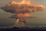 Redoubt Volcano |
Mount Mageik | 7103 ft | 2165 m | Alaska | 58.2° N | 155.3° W | ||||||
| Mount Griggs | 7602 ft | 2317 m | Alaska | 58.4° N | 155.1° W | |||||||
| Mount Katmai | 6716 ft | 2047 m | Alaska | 58.3° N | 155.0° W | |||||||
| Mount Douglas | 7005 ft | 2135 m | Alaska | 58.9° N | 153.5° W | |||||||
| Augustine Volcano | 4108 ft | 1252 m | Alaska | 59.4° N | 153.4° W | |||||||
| Iliamna Volcano | 10016 ft | 3053 m | Alaska | 60.0° N | 153.1° W | |||||||
| Redoubt Volcano | 10198 ft | 3108 m | Alaska | 60.5° N | 152.7° W | |||||||
| Mount Spurr | 11070 ft | 3374 m | Alaska | 61.3° N | 152.3° W | |||||||
| Denali (Mt McKinley) | 20320 ft | 6194 m | Alaska | 63.1° N | 151.0° W | |||||||
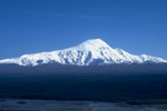 Mount Sanford |
Mount Drum | 12010 ft | 3661 m | Alaska | 62.1° N | 144.6° W | ||||||
| Mount Sanford | 16237 ft | 4949 m | Alaska | 62.2° N | 144.1° W | |||||||
| Mount Wrangell | 14163 ft | 4317 m | Alaska | 62.0° N | 144.0° W | |||||||
| Mount Blackburn | 16390 ft | 4996 m | Alaska | 61.7° N | 143.4° W | |||||||
| Mount Bona | 16421 ft | 5005 m | Alaska | 61.4° N | 141.8° W | |||||||
| Mount Churchill | 15638 ft | 4766 m | Alaska | 61.4° N | 141.7° W | |||||||
| Mount Saint Elias | 18008 ft | 5489 m | Alaska / Yukon | 60.3° N | 140.9° W | |||||||
| Mount Logan | 19534 ft | 5954 m | Yukon | 60.6° N | 140.4° W | |||||||
| Mount Fairweather | 15320 ft | 4669 m | Alaska / British Columbia | 58.9° N | 137.5° W | |||||||
| Mount Edgecumbe | 3201 ft | 976 m | Alaska | 57.1° N | 135.8° W | |||||||
| Hoodoo Mountain | 5971 ft | 1820 m | British Columbia | 56.8° N | 131.3° W | |||||||
| Mount Edziza | 9144 ft | 2787 m | British Columbia | 57.7° N | 130.6° W | |||||||
|
Western United States & Canada:
Regional Map and Introduction
|
||||||||||||
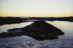 Crater Lake |
Cascade Volcanoes The volcanoes of the Cascade Range in California, Oregon, Washington, and British Columbia were previously listed in this section. They have now been moved to a separate guidebook section of their own, Skiing the Cascade Volcanoes. |
|||||||||||
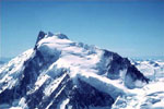 Mount Waddington |
Rainbow Range | 8130 ft | 2478 m | British Columbia | 52.7° N | 125.8° W | ||||||
| Ilgachuz Range | 7901 ft | 2408 m | British Columbia | 52.8° N | 125.3° W | |||||||
| Itcha Range | 7768 ft | 2368 m | British Columbia | 52.7° N | 124.8° W | |||||||
| Silverthrone Mountain | 9400 ft | 2860 m | British Columbia | 51.4° N | 126.3° W | |||||||
| Mount Waddington | 13186 ft | 4019 m | British Columbia | 51.4° N | 125.3° W | |||||||
| Mount Munday | 11046 ft | 3367 m | British Columbia | 51.3° N | 125.2° W | |||||||
| Yellowstone Caldera | 10308 ft | 3142 m | Wyoming | 44.4° N | 110.7° W | |||||||
| Craters of the Moon | 6515 ft | 1986 m | Idaho | 43.4° N | 113.5° W | |||||||
| Mammoth Mountain | 11053 ft | 3369 m | California | 37.6° N | 119.0° W | |||||||
 Mammoth Mountain |
Mount Williamson | 14375 ft | 4381 m | California | 36.7° N | 118.3° W | ||||||
| Mount Whitney | 14494 ft | 4418 m | California | 36.6° N | 118.3° W | |||||||
| Humphreys Peak | 12633 ft | 3851 m | Arizona | 35.3° N | 111.7° W | |||||||
| Mount Baldy | 11420 ft | 3481 m | Arizona | 33.9° N | 109.6° W | |||||||
| Mount Taylor | 11301 ft | 3445 m | New Mexico | 35.2° N | 107.6° W | |||||||
| Valles Caldera | 11561 ft | 3524 m | New Mexico | 35.9° N | 106.6° W | |||||||
|
Mexico & Central America:
Regional Map and Introduction
|
||||||||||||
 Popocatepetl |
Nevado de Colima | 14240 ft | 4340 m | Mexico | 19.6° N | 103.6° W | ||||||
| Nevado de Toluca | 15390 ft | 4690 m | Mexico | 19.1° N | 99.8° W | |||||||
| Iztaccihuatl | 17160 ft | 5230 m | Mexico | 19.2° N | 98.6° W | |||||||
| Popocatepetl | 17930 ft | 5465 m | Mexico | 19.0° N | 98.6° W | |||||||
| La Malinche | 14636 ft | 4461 m | Mexico | 19.2° N | 98.0° W | |||||||
| Cofre de Perote | 14408 ft | 4282 m | Mexico | 19.5° N | 97.2° W | |||||||
| Pico de Orizaba | 18410 ft | 5611 m | Mexico | 19.0° N | 97.3° W | |||||||
| Sierra Negra | 15030 ft | 4580 m | Mexico | 18.9° N | 97.4° W | |||||||
| Volcán Tajumulco | 13846 ft | 4220 m | Guatemala | 15.0° N | 91.9° W | |||||||